Antiquarian Maps: 17th-20th Century 2016-10-23 Auction - 79 Price Results - Jasper52 in NY - Page 2
LiveAuctioneers Logo

Southwest Germany 1522/1541Carolina & Bermuda 1716Notorious Pirate Haven Barbary Coast 1666
Done
New York, NY, United States
Auction Details

Antiquarian Maps: 17th-20th Century

Jasper52

Jasper52

badge TOP RATED
Produced by preeminent cartographers, such as the Dutch master Jan Jansson, these 17th-20th century maps reveal innumerable ways to view the globe. Unlike modern charts, the atlases trace borders that shifted with each exploration. Allow discoverers to guide you through historical territories, ranging from the German Empire to Nebraska’s railroad system. Among the highlights is a depiction of a notorious pirate haven along the coast of Morocco. Anchors aweigh for a sale that is all over the map.
Lot Number: Lowest
24
Sold
Bavaria / Southern Germany c. 1550: Map Title: Sveviae Et Bavariae DescriptioPublished: Munster, S., BaselDate: c. 1550Size: 10 5/8 x 13 1/2 inches. An attractive early woodcut map of Bavaria/ Southern Germany. A picturesque, early
0025: Bavaria / Southern Germany c. 1550Est. $250-$400
See Sold Price
Southwest Germany 1522/1541: Map Title: Tabula Nova Provinciarum Rheni (The Rhineland Richly Evoked Baden-Wurttemberg/ Black Forest/ Germany/ Alsace-Lorraine)Published: Fries, L./ Waldseemuller, M., Vienne-in-the-DauphaneDate:
0026: Southwest Germany 1522/1541Est. $450-$600Lot Passed
Prussia by Allen Bell 1837: Map Title: PrussiaMaker: Allen BellDate: 1837Origin: Allen Bell & Company, LondonSize: 14 x 18.5 inchesMedium: Engraving No Reserve: This lot starts at $1 and has no reserve as a courtesy so that
0027: Prussia by Allen Bell 1837Est. $250-$400Lot Passed
Czech Republic 1636: Map Title: Marchionatus Moraviae Auct. J. Comenio (With English Text)Published: Hondius, H./ Jansson, J. AmsterdamDate: 1636Size: 15.25 x 21.5 inches. Finely detailed map from the scarce English
0028: Czech Republic 1636Est. $250-$350Lot Passed
Montgomery County, Wales 1646: Map Title: Mervinia et Montgomeria ComitatusPublisher: Blaeu, W. AmsterdamDate: 1646Size: 15 x 19.75 inches. Attractive map of part of Wales showing what is now part of the county of Powys. The
0029: Montgomery County, Wales 1646Est. $250-$350Lot Passed
North Wales 1636: Map Title: Westmorlandia Lancastria, Cestria, Caernarvan Published: Jansson, J./ Hondius, H.Origin: Amsterdam,Date: 1636Size: 14 x 16.25 inches The Very Scarce English Edition of Lancashire/
0031: North Wales 1636Est. $250-$400Lot Passed
Northern France 1647: Map Title: Picardia Regio BelgicaPublished: Blaeu, W. & J., AmsterdamDate: 1647Size: 15 x 21 inches Richly colored map of Picardy in Northern France along the Somme River, with a Charming Cartouche
0032: Northern France 1647Est. $400-$550Lot Passed
Oxfordshire by John Speed 1611: Map Title: Oxfordshire described with ye Citie and the Armes of the Colledges of ye famous University AoArtist: John SpeedPublisher: John Sudbury and George Humbell, Popes Head Alley, LondonDate:
0033: Oxfordshire by John Speed 1611Est. $1,500-$2,000Lot Passed
Sold
Amsterdam 1814: Map Title: Carte Intineraire d'Amsterdam a Utrecht et NaardenSubject: AmsterdamMedium: Copper engravingDate: 1814Size: 11 x 14 inches No Reserve: This lot starts at $1 and has no reserve as a
0035: Amsterdam 1814Est. $150-$300
See Sold Price
Sold
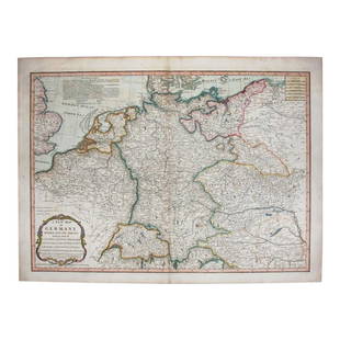
Holy Roman Empire 1805: Map Title: The Holy Roman Empire in its Final Year Germany/ Poland/ Czech Republic/ Austria/ Netherlands (A New Map Of Germany Divided Into Its Circles).Published: Laurie & Whittle, LondonDate: 1805
0037: Holy Roman Empire 1805Est. $200-$350
See Sold Price
Japan, China & Korea, 1707: Map Title: Magnae Tartariae Magni Mogolis Imperii Laponiae et ChinaeSubject: Japan, China & KoreaDate: 1707Origin: Witsen (De Wit), AmsterdamSize: 26.25 x 26.5 inchesMedium: Copperplate engraving
0042: Japan, China & Korea, 1707Est. $950-$1,200Lot Passed
Sold
Spice Islands Indonesia/ Moluccas, 1636: Map Title: Insularum Moluccarum Nova descriptio (The Fabled Spice Islands Indonesia/ Moluccas)Published: Hondius, H./ Jansson, J., AmsterdamDate: 1636Size: 15 x 19 1/2 inches (engraved surface
0043: Spice Islands Indonesia/ Moluccas, 1636Est. $400-$550
See Sold Price
Sold
America by Herman Moll 1716: Map Title: America, According to the Newest and Most Exact ObservationsMaker: Herman MollDate: 1716Origin: Atlas GeographicusSize: 13 x 16 inchesMedium: Copperplate engraving Herman Moll (1654-1732)
0046: America by Herman Moll 1716Est. $400-$500
See Sold Price
Sold
Middle States of United States 1829: Map Title: Map of the Middle StatesMaker: RobinsonOrigin: Atlas GeographicusDate: 1829Size: 21.25 x 14.25 inchesMedium: EngravingFrom "Olney's School of Geography" Jesse Olney (1798-1872) was a
0048: Middle States of United States 1829Est. $50-$150
See Sold Price
View:
24
TOP