


Done
London, United Kingdom
Auction Details
Maps and Atlases
Bloomsbury's forthcoming sale of Maps and Atlases (13th October) is a mixed owner sale of 409 lots and has been divided into Atlases, Foreign Maps and British Maps. This is a good all-round sale appealing to a wide range of buyers.
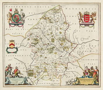
Amongst the Atlases, particularly noteworthy is lot 24, a Novus Atlas Sinensis by J Blaeu (Amsterdam 1655), with 16 double page engraved maps comprising general maps of China and Japan, and 14 of Chinese Provinces, all with outline hand-colouring (estimated £6000-8000). Lot 20, with an estimate of £800-£1200, is a Yojida atlas from Korea, with woodcut maps of China, showing the Great Wall, Japan, Korea and a typical doughnut-shaped 'shanhaijing', or World map. Another item in this section is lot 37 Epitome Trium Terrae Patrium by Joachim von Watte, known as Vadianus (estimated £2000-3000). It has 2 full-page woodcuts, Circuli Sphaerae (which bears the date 1530) and Ordo Planetarum cum aspectibus, and 12 of 13 hand-coloured woodcut maps.
Amongst the Foreign Maps is an engraved map by Gerard Mercator of Florida and Virginia, datable to around1630 (lot 58). Virginia Item et Floridae Americae Provinciarum, nova descripto has an attractive ornamental cartouche, native figures, animals, a turkey and ships with sea monsters and has an estimate of £1200-1800. Asia Noviter Delineata, an engraved map of Asia (lot 64) decorated with boders containing costumed figures by Johan Blaeu (c1640) is estimated £2500-3500. A highlight of the sale is John Speed's A New and Accurat Map of the World Drawne According to Ye Truest Descriptions Latest Discoveries & Best Observations Yet Have Beene Made by English or Strangers, a good example from Speed's Prospect of the Most Famous Parts of the World (lot 284). This handsome hand-coloured map with decorative borders of allegorical figures, portraits of explorers and celestial hemispheres, is estimated £5000-7000.
Lot Number: Lowest
24


![[Jansson (Jan)] Orcadum et Schetlandiæ: [Jansson (Jan)] Orcadum et Schetlandiæ Insularum accuratissima descriptio, the Orkneys and Shetland Islands described in 2 adjoining panels, with numerous ships and title cartouche adorned with](https://p1.liveauctioneers.com/410/3027/1300495_1_x.jpg?height=310&quality=70)


![[Blaeu (Johannes)] Staffordshire: Staffordshire.- [Blaeu (Johannes)] Staffordiensis Comitatus Vulgo Staffordshire, engraved map of Staffordshire, with hand-colouring, pictorial cartouche and coats-of-arms, 410 x 500mm., Latin text on](https://p1.liveauctioneers.com/410/3027/1300500_1_x.jpg?height=310&quality=70)
![[Blaeu (J & W)] Glamorganensis Comitatus;: [Blaeu (J & W)] Glamorganensis Comitatus; vulgo Glamorganshire, engraved map of Glamorganshire, ornamental cartouche, numerous ships, with original hand-colouring, 385 x 510mm., Latin text on verso,](https://p1.liveauctioneers.com/410/3027/1300502_1_x.jpg?height=310&quality=70)
![Blaeu (J) Monumethensis Comitatus: [Blaeu (J & W)] Monumethensis Comitatus vernacule Monmouth Shire, engraved map of Monmouth with the river Severn and part of Gloucestershire, pictorial cartouche, with hand-colouring, 385 x 500mm.,](https://p1.liveauctioneers.com/410/3027/1300503_1_x.jpg?height=310&quality=70)
![[Blaeu (J & W)] Montgomeria comitatus: [Blaeu (J & W)] Montgomeria comitatus et comitatus Mervinia, engraved map of north-west Wales, decorative cartouche and coats-of-arms, with hand-colouring, 385 x 500mm., Dutch text on verso, some](https://p1.liveauctioneers.com/410/3027/1300504_1_x.jpg?height=310&quality=70)
![[Blaeu (Johannes)] Caernarvonshire & Anglesey: [Blaeu (Johan)] Comitatus Caernarvoniensis, vernacule Caernarvon-shire et Mona Insula vulgo Anglesey, decorative title cartouche, armorials and ships, engraved map with hand-colouring, 385 x 505mm.,](https://p1.liveauctioneers.com/410/3027/1300505_1_x.jpg?height=310&quality=70)
![[Blaeu (Johannes)] Denbigh & Flint: [Blaeu (Johannes)] Denbigiensis Comitatus et Comitatus Flintensis, engraved map of Denbigh and Flintshire with hand-colouring, decorative cartouche and coats-of-arms, 385 x 495mm., Latin text on](https://p1.liveauctioneers.com/410/3027/1300506_1_x.jpg?height=310&quality=70)
![[Blaeu (Johannes)] Breknock: [Blaeu (Johannes)] Comitatus Brechiniae, Breknoke, engraved map of Brecon, with hand-colouring, decorative cartouche, coats-of-arms, 380 x 502mm., Latin text on verso, [Amsterdam], [1646].](https://p1.liveauctioneers.com/410/3027/1300507_1_x.jpg?height=310&quality=70)

![Blaeu (J & W) Ducatus Eboracensis: [Blaeu (J & W)] Ducatus Eboracensis pars Orientalis, engraved map of the East Riding of Yorkshire, ornamental cartouche, numerous coats-of-arms, with hand-colouring, 380 x 505mm., Dutch text on](https://p1.liveauctioneers.com/410/3027/1300509_1_x.jpg?height=310&quality=70)
![[Blaeu (Johan)] The Eastriding of Yorkeshire: [Blaeu (Johan)] Ducatus Eboracensis Pars Orientalis,The Eastriding of Yorkeshire engraved map with original hand-colouring, 385 x 510mm., French text verso, slight creasing around central vertical](https://p1.liveauctioneers.com/410/3027/1300510_1_x.jpg?height=310&quality=70)
![[Blaeu (Johannes)] Yorkshire: [Blaeu (Johannes)] Ducatus Eboracensis Anglice Yorkshire, engraved map of Yorkshire with hand-colouring, ornamental cartouche, coats-of-arms, 390 x 500mm., Latin text on verso, fine japon paper](https://p1.liveauctioneers.com/410/3027/1300511_1_x.jpg?height=310&quality=70)


![Ellis (J) A Modern Map of Yorkshire: Ellis (J) A Modern Map of Yorkshire; The East Riding...; The North Riding..., together 3 small maps of Yorkshire with decorative cartouches, 195 x 245mm., Bowles & Sayer, [1766], and 2 others, a map](https://p1.liveauctioneers.com/410/3027/1300514_1_x.jpg?height=310&quality=70)

![Speed (John) York Shire: Speed (John) York Shire, engraved map of Yorkshire with ornamental cartouche, 385 x 510mm., Latin text on verso, very light text showthrough, tipped-in to window mount, Sudbury & Humble, 1610 [1611].](https://p1.liveauctioneers.com/410/3027/1300516_1_x.jpg?height=310&quality=70)
View:
24
Auction Details

Bid Increments
PriceBid Increment
TOP