Sold20211838 Thomas Bradford Atlas Map of MichiganAtlas map of Michigan showing then current counties, towns, etc. Hand colored borders. Along the bottom margin: “Entered according to Act of Congress in the year 1838 by T.G. Bradford in the ClerksSee Sold Price
Sold2016(4) 1838 BRADFORD Maps: OH, IN, MI, TN[United States/Near West] 4 Maps. ++ OHIO. ++ INDIANA. ++ MICHIGAN. [With inset of upper peninsula.] ++ TENNESSEE. ++ Maps 19, 20, 22, 29 from T. G. Bradford, “An Illustrated Atlas, Geographical, StSee Sold Price
Sold2017Bradford: Antique Map of Louisiana, 1838Title/Content of Map: Louisiana by Bradford Date Printed: 1838/1841 Cartographer: Thomas G. Bradford Material/Medium: Paper Size: 16 1/2" x 13" Hand colored. A General Atlas of the World with a SeparaSee Sold Price
Sold2017Bradford: Antique Map of New Hampshire, 1838Title/Content of Map: New Hampshire by Bradford Date Printed: 1838/1841 Cartographer: Thomas G. Bradford Material/Medium: Paper Size: 13" x 16 1/2" Hand colored. A General Atlas of the World with a SeSee Sold Price
Sold2017Bradford: Antique Map of Kentucky, 1838Title/Content of Map: Kentucky by Bradford Date Printed: 1838/1841 Cartographer: Thomas G. Bradford Material/Medium: Paper Size: 16 1/2" x 13" Hand colored. A General Atlas of the World with a SeparatSee Sold Price
Sold2017Bradford: Antique Map of Pennsylvania, 1838Title/Content of Map: Pennsylvania by Bradford Date Printed: 1838/1841 Cartographer: Thomas G. Bradford Material/Medium: Paper Size: 16 1/2" x 13" Hand colored. A General Atlas of the World with a SepSee Sold Price
Sold2017Bradford: Antique Map of Massachusets, 1838Title/Content of Map: Massachusets by Bradford Date Printed: 1838/1841 Cartographer: Thomas G. Bradford Material/Medium: Paper Size: 13" x 16 1/2" Hand colored. A General Atlas of the World with a SepSee Sold Price
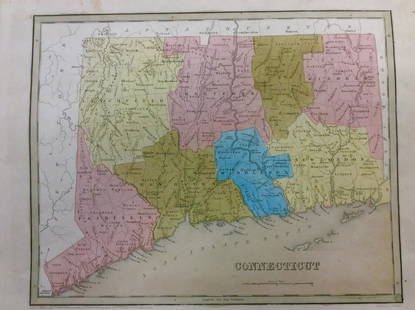
2017Bradford: Antique Map of Conneticut, 1838Title/Content of Map: Conneticut by Bradford Date Printed: 1838/1841 Cartographer: Thomas G. Bradford Material/Medium: Paper Size: 13" x 16 1/2" Hand colored. A General Atlas of the World with a SeparSee Sold Price
Sold2017T.G Bradford: Antique Map of United States, 1838Title: Map of United States by T.G Bradford Date: 1838 Medium: Wax Engraving Dimensions (in): 25 x 16 Condition: Excellent Condition Thomas G. Bradford was the author of the Illustrated Atlas of the USee Sold Price
Sold2017Bradford: Antique Map of Ohio, 1838Title/Content of Map: Ohio by Bradford Date Printed: 1838/1841 Cartographer: Thomas G. Bradford Material/Medium: Paper Size: 13" x 16 1/2" Hand colored. A General Atlas of the World with a Separate MaSee Sold Price
Sold2017Africa by BradfordTitle/Content of Map: Africa by Bradford Date Printed: 1838/1841 Cartographer: Thomas G. Bradford Material/Medium: Paper Size: 13 1/4" x 16 3/4" A General Atlas of the World, with a seperate Map of eaSee Sold Price
Sold2017Bradford: Antique Map of Upper Canada, 1838Map: Upper Canada Date Printed: 1838/1841 Cartographer: Thomas G. Bradford Material/Medium: Paper Size: 16 1/2" x 13 1/2" Hand colored. A General Atlas of the World, with a seperate map of each of theSee Sold Price
Sold2017Bradford: Antique Map of the West Indies, 1838Title/Content of Map: Bradford's West Indes Date Printed: 1838/1841 Cartographer: Thomas G. Bradford Material/Medium: Paper Size: 16 3/4" x 13 1/4" Hand colored. A General Atlas of the World with a SeSee Sold Price
Sold2017Bradford: Antique Map of New Hemisphere, 1838Title/Content of Map: New Hemisphere by Bradford Date Printed: 1838/1841 Cartographer: Thomas G. Bradford Material/Medium: Paper Size: 13" x 16 1/2" A General Atlas of the World with a seperate Map ofSee Sold Price
Sold2017Bradford: Antique Map of Vermont, 1838Title/Content of Map: Vermont by Bradford Date Printed: 1838/1841 Cartographer: Thomas G. Bradford Material/Medium: Paper Size: 13" x 15" A General Atlas of the World with a seperate Map of each of thSee Sold Price
Sold2017Bradford: Antique Map of West Indies, 1838Title: Map of West Indies by Bradford Date: 1838 Medium: Copper Engraving Dimensions (in): 16 x 13 Condition: Good Condition Thomas G. Bradford was the author of the Illustrated Atlas of the United StSee Sold Price
Sold2017Bradford: Antique Map of Iowa & Wisconsin, 1838Title/Content of Map: Rare and Important early Iowa and Wisconsin Date Printed: 1838/1841 Cartographer: Thomas G. Bradford Material/Medium: Paper Size: 13" x 16 1/2" Hand colored. A General Atlas of tSee Sold Price
Sold20174 TN Maps, Bradford, 1835, 1838, & 18411st item: "Tennessee" Map, by Thomas G. Bradford, engraved by George W. Boynton, published by William D. Ticknor, Boston, 1835. From "A Comprehensive Atlas, Geographical, Historical & Commercial" by TSee Sold Price
Sold2017Bradford: Antique Map of Philadelphia, 1838Title/Content of Map: Philadelphia b Bradford Date Printed: 1838/41 Cartographer: Thomas G. Bradford Material/Medium: Paper Size: 13" x 16 3/4" Condition: Excellent Hand colored. A General Atlas of thSee Sold Price
Sold2017Bradford: Antique Map of Maine, 1838Title/Content of Map: Maine by Bradford Date Printed: 1838/1841 Cartographer: Thomas G. Bradford Material/Medium: Paper Size: 13" x 16 1/2" Hand colored. A General Atlas of the World with a Separate MSee Sold Price
Sold2017Bradford: Antique Map of Tennessee, 1838Title/Content of Map: Tennessee by Bradford Date Printed: 1838/1841 Cartographer: Thomas G. Bradford Material/Medium: Paper Size: 13" x 16 1/2" Hand colored. A General Atlas of the World with a SeparaSee Sold Price
Sold2017Bradford: Antique Map of Philadelphia, 1838Title/Content of Map: Philadelphia by Bradford Date Printed: 1838/1841 Cartographer: Thomas G. Bradford Material/Medium: Paper Size: 16 3/4" x 13" Hand colored. A General Atlas of the World with a sepSee Sold Price
Sold2017Bradford: Antique Map of New Jersey, 1838Title/Content of Map: New Jersey by Bradford Date Printed: 1838/1841 Cartographer: Thomas G. Bradford Material/Medium: Paper Size: 13" x 16 1/2" Condition: Excellent Hand colored. A General Atlas of tSee Sold Price
Sold2017Bradford: Antique Map of Arkansas, 1838Title/Content of Map: Arkansas by Bradford Date Printed: 1838/1841 Cartographer: Thomas G. Bradford Material/Medium: Paper Size: 13" x 16 1/2" Hand colored. A General Atlas of the World with a SeparatSee Sold Price
Jun 14DuMouchellesThomas Bradford (American, 1802-1887) Hand Colored Engraving "Northwest Part of Michigan", H 15.5" WUS$50(1 bid)
Jun 14DuMouchellesWilliam H. Gamble (American, B. 1863) Hand Colored Engraving, Ca. 1863, "County Map of Michigan AndUS$50(1 bid)
3 days LeftForum Auctionsd'Anville (Jean Baptiste Bourguignon) [Untitled Composite Atlas with 102 map sheets], [probably£2,000
Jun 07Freeman's | HindmanHUGHES, Griffith. The Natural History of Barbados. 1750. FIRST EDITION.US$1,000
Jun 08Early American History Auctionsc 1730 Hand-Colored Colonial Era Map of the Americas, California shown as an Island, Matted + FramedUS$500(1 bid)
3 days LeftLeland LittleEnglish School (19th Century), Five Racehorse and Jockey Portraits Published by Sporting GalleryUS$50
5 days LeftTrillium Antique Prints & Rare BooksSanson - Map of Canada or New France with the Great LakesUS$75
5 days LeftTrillium Antique Prints & Rare BooksSanson - Map of Florida (encompassing most of Southeast North America)US$75(1 bid)


![(4) 1838 BRADFORD Maps: OH, IN, MI, TN: [United States/Near West] 4 Maps. ++ OHIO. ++ INDIANA. ++ MICHIGAN. [With inset of upper peninsula.] ++ TENNESSEE. ++ Maps 19, 20, 22, 29 from T. G. Bradford, “An Illustrated Atlas, Geographical, St](https://p1.liveauctioneers.com/179/85723/44107994_1_x.jpg?height=310&quality=70&version=1457208874)


![d'Anville (Jean Baptiste Bourguignon) [Untitled Composite Atlas with 102 map sheets], [probably (1 of 3)](https://p1.liveauctioneers.com/5458/329231/177514974_1_x.jpg?height=282&quality=70&version=1715269091)


