Sold2017Bradford: Antique Map of Upper Canada, 1838Map: Upper Canada Date Printed: 1838/1841 Cartographer: Thomas G. Bradford Material/Medium: Paper Size: 16 1/2" x 13 1/2" Hand colored. A General Atlas of the World, with a seperate map of each of theSee Sold Price
Sold2017Bradford: Antique Map of Lower Canada, 1838Title/Content of Map: Lower Canada and New Brunswick Date Printed: 1838/1841 Cartographer: Thomas G. Bradford Material/Medium: Paper Size: 16 1/2" x 13 1/2" Hand colored. A General Atlas of the WorldSee Sold Price
Sold2018Ettling: Antique Map of Upper Canada, 1863TITLE/CONTENT OF MAP: 'Upper Canada' Lakes Huron, Erie & ONTARIO. Counties. Railways. DATE PRINTED: 1863 IMAGE SIZE: Approx 32.0 x 44.5cm, 12.5 x 17.5 inches (Large) TYPE: Antique map with original ouSee Sold Price
Sold2018Colton: Antique Map of Upper Canada, 1859Title/Content of Map: Upper Canada by Colton Date Printed: 1859 Cartographer: H.J. Colton Material/Medium: Paper Size: 17 1/2" x 15" Hand colored, engraved Map. Published in New York in Colton's 'GeneSee Sold Price
Sold2017Tanner: Antique Map of Upper Canada, 1843Title/Content of Map: Upper Canada by Tanner Date Printed: 1843 Cartographer: based on the work of H.C. Tanner Material/Medium: Paper Size: 17" x 14" Hand colored engraved Map. From the first editionSee Sold Price
Sold2017Cary: Antique Map of Upper & Lower Canada, 1807Map: A New Map of Upper & Lower Canada Cartographer: John Cary Place & Date: London / 1807 Size: 20 1/4" x 18" Condition: original color; light overall age toning; a repaired nick in the edge of the uSee Sold Price
Sold2017Bradford: Antique Map of Louisiana, 1838Title/Content of Map: Louisiana by Bradford Date Printed: 1838/1841 Cartographer: Thomas G. Bradford Material/Medium: Paper Size: 16 1/2" x 13" Hand colored. A General Atlas of the World with a SeparaSee Sold Price
Sold2017Bradford: Antique Map of Ohio, 1838Title/Content of Map: Ohio by Bradford Date Printed: 1838/1841 Cartographer: Thomas G. Bradford Material/Medium: Paper Size: 13" x 16 1/2" Hand colored. A General Atlas of the World with a Separate MaSee Sold Price
Sold2017Bradford: Antique Map of Philadelphia, 1838Title/Content of Map: Philadelphia b Bradford Date Printed: 1838/41 Cartographer: Thomas G. Bradford Material/Medium: Paper Size: 13" x 16 3/4" Condition: Excellent Hand colored. A General Atlas of thSee Sold Price
Sold2017Bradford: Antique Map of Maine, 1838Title/Content of Map: Maine by Bradford Date Printed: 1838/1841 Cartographer: Thomas G. Bradford Material/Medium: Paper Size: 13" x 16 1/2" Hand colored. A General Atlas of the World with a Separate MSee Sold Price
Sold2017Bradford: Antique Map of Tennessee, 1838Title/Content of Map: Tennessee by Bradford Date Printed: 1838/1841 Cartographer: Thomas G. Bradford Material/Medium: Paper Size: 13" x 16 1/2" Hand colored. A General Atlas of the World with a SeparaSee Sold Price
Sold2017Bradford: Antique Map of Philadelphia, 1838Title/Content of Map: Philadelphia by Bradford Date Printed: 1838/1841 Cartographer: Thomas G. Bradford Material/Medium: Paper Size: 16 3/4" x 13" Hand colored. A General Atlas of the World with a sepSee Sold Price
Sold2017Bradford: Antique Map of Kentucky, 1838Title/Content of Map: Kentucky by Bradford Date Printed: 1838/1841 Cartographer: Thomas G. Bradford Material/Medium: Paper Size: 16 1/2" x 13" Hand colored. A General Atlas of the World with a SeparatSee Sold Price
Sold2017Bradford: Antique Map of Arkansas, 1838Title/Content of Map: Arkansas by Bradford Date Printed: 1838/1841 Cartographer: Thomas G. Bradford Material/Medium: Paper Size: 13" x 16 1/2" Hand colored. A General Atlas of the World with a SeparatSee Sold Price
Sold2017Bradford: Antique Map of Illinois, 1838Title/Content of Map: Illinois by Bradford Date Printed: 1838/1841 Cartographer: Thomas G. Bradford Material/Medium: Paper Size: 13" x 16 1/2" Hand colored. A General Atlas of the World with a SeparatSee Sold Price
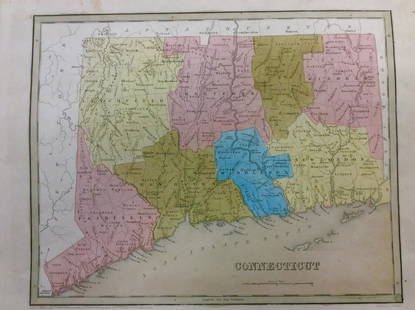
Sold2018Bradford: Antique Map of Connecticut, 1838Title/Content of Map: Connecticut by Bradford Date Printed: 1838 Cartographer: Thomas G. Bradford Size: 14" x17" Material/Medium: Paper Provenance: New York A General Atlas of the World with a separatSee Sold Price
Sold2017Bradford: Antique Map of Alabama, 1838Title/Content of Map: Alabama by Bradford Date Printed: 1838/1841 Cartographer: Thomas G. Bradford Material/Medium: Paper Size: 13" x 16 1/2" Hand colored. A General Atlas of the World with a SeparateSee Sold Price
Sold2017Bradford: Antique Map of Pennsylvania, 1838Title/Content of Map: Pennsylvania by Bradford Date Printed: 1838/1841 Cartographer: Thomas G. Bradford Material/Medium: Paper Size: 16 1/2" x 13" Hand colored. A General Atlas of the World with a SepSee Sold Price
Sold2017Bradford: Antique Map of Indiana, 1838Title/Content of Map: Indiana by Bradford Date Printed: 1838/1841 Cartographer: Thomas G. Bradford Material/Medium: Paper Size: 13" x 16 1/2" Hand colored. A General Atlas of the World with a SeparateSee Sold Price
Sold2017Bradford: Antique Map of Massachusets, 1838Title/Content of Map: Massachusets by Bradford Date Printed: 1838/1841 Cartographer: Thomas G. Bradford Material/Medium: Paper Size: 13" x 16 1/2" Hand colored. A General Atlas of the World with a SepSee Sold Price
2017Bradford: Antique Map of Conneticut, 1838Title/Content of Map: Conneticut by Bradford Date Printed: 1838/1841 Cartographer: Thomas G. Bradford Material/Medium: Paper Size: 13" x 16 1/2" Hand colored. A General Atlas of the World with a SeparSee Sold Price
Sold2017Bradford: Antique Map of Vermont, 1838Title/Content of Map: Vermont by Bradford Date Printed: 1838/1841 Cartographer: Thomas G. Bradford Material/Medium: Paper Size: 13" x 15" A General Atlas of the World with a seperate Map of each of thSee Sold Price
Sold2017Colton: Antique Map of West & Upper Canada, 1861Map: Canada West/Upper Canada Date Printed: 1861 Cartographer: J.H. Colton Material/Medium: Paper Size: 17 1/2" x 14" Hand colored, steel engraved. Printed in New York. From Colton's 'General Atlas'.See Sold Price
Sold2017Bradford: Antique Map of British Canada, 1835Map: British Canada 1835 Date Printed: 1835 Cartographer: Thomas G. Bradford Material/Medium: Paper Size: 13' x 10" Hand colored outlines. From a Comprehensive Atlas Geographical, Historical & CommercSee Sold Price
4 days LeftAlbion AuctionsGlasgow Geography 1825 Antique Map. Canada - British Possessions in AmericaUS$5(1 bid)
Jun 30Broward Auction GalleryJohn Arthur Fraser (NY,Canada,1838-1898) watercolor painting antiqueUS$10(1 bid)
4 days LeftAlbion AuctionsClarke & Russell 1814 Hand Col Map. Canada - British Dominions in North AmericaUS$25(3 bids)
4 days LeftAlbion AuctionsBlackie (Pub) 1882 Folio Map. Canada - Quebec, Nova Scotia, New Brunswick, Prince EdwardUS$5
Featured3 days LeftJasper52BALKANS. Pannonie/Pannonia Illyria. Croatia Bosnia Serbia. MALLET 1683 old mapUS$40
May 26Ararity AuctionsThomson's 1817 Hand Colored Map Comparative Heights of the World's Great MountainsUS$50
May 25Aurora Antique Auction House LtdOverseas Return Weiqi set (originally with board) (Sunspot: Obsidian Baizi: CQ)US$300
May 25Aurora Antique Auction House LtdHuang Binhong Landscape Map horizontal axis (insect resident)US$300
May 25Aurora Antique Auction House LtdWanli 45 April Jizao town Kubao silver ingots weigh one hundred and twoUS$500