Sold20211884 Mitchell Map of North and South Carolina -- NorthTitle: 1884 Mitchell Map of North and South Carolina -- North and South Carolina Cartographer: S Mitchell Year / Place: 1884, Philadelphia Map Dimension (in.): 11.3 X 14 in. This is a very nice map ofSee Sold Price
Sold20221877 Mitchell Map of North and South Carolina -- North and South CarolinaTitle: 1877 Mitchell Map of North and South Carolina -- North and South Carolina Cartographer: S Mitchell Date/Place: 1877 Philadelphia Dimensions: 10.5 x 13.5 in. Description: This is an excellent anSee Sold Price
Sold20211887 Mitchell Map of North and South Carolina -- NorthTitle: 1887 Mitchell Map of North and South Carolina -- North and South Carolina Cartographer: S Mitchell Year / Place: 1887, Philadelphia Map Dimension (in.): 11.3 X 14 in. A very nice map of the CarSee Sold Price
Sold20181876 Mitchell Map of North and South Carolina -- NorthReserve Reduced! Title/Content of Map: 1876 Mitchell Map of North and South Carolina -- North and South Carolina Date: 1876 Philadelphia Cartographer: S Mitchell Size: 10.5 x 13.5 in. Excellent and hiSee Sold Price
Sold20181867 Mitchell Map of North and South Carolina -- CountyTitle/Content of Map: 1867 Mitchell Map of North and South Carolina -- County Map of North and South Carolina Date: 1867, Philadelphia Cartographer: S Mitchell Size: 11.5 x 13.8 in. This is a handsomeSee Sold Price
Sold20201860 Mitchell Map of Florida, South and North CarolinaTitle/Content of Map: 1860 Mitchell Map of Florida, South and North Carolina -- County Map of Florida on page with Map of South Carolina, on page with County Map of North Carolina Cartographer: S MitcSee Sold Price
Sold20231860 Mitchell Map of Florida, South and North Carolina -- County Map of Florida on page with Map ofTitle: 1860 Mitchell Map of Florida, South and North Carolina -- County Map of Florida on page with Map of South Carolina, on page with County Map of North Carolina Cartographer: S Mitchell Year / PlaSee Sold Price
Sold20211860 Mitchell Map of Florida, South and North CarolinaTitle: 1860 Mitchell Map of Florida, South and North Carolina -- County Map of Florida on page with Map of South Carolina, on page with County Map of North Carolina Cartographer: S Mitchell Year / PlaSee Sold Price
Sold2017Mitchell Map of Florida, South and North Carolina, 1860Title: 1860 Mitchell Map of Florida, South and North Carolina Cartographer: S Mitchell Published: 1860, Philadelphia Measurements: 10.6 X 13.5 in. County Map of Florida on page with Map of South CarolSee Sold Price
Sold20181863 Mitchell Map of Florida, South and North CarolinaTitle/Content of Map: 1863 Mitchell Map of Florida, South and North Carolina -- County Map of Florida on page with Map of South Carolina, on page with County Map of North Carolina Date: 1863, PhiladelSee Sold Price
Sold20181860 Mitchell Map of Florida, South and North CarolinaTitle/Content of Map: 1860 Mitchell Map of Florida, South and North Carolina -- County Map of Florida on page with Map of South Carolina, on page with County Map of North Carolina Date Printed: 1860,See Sold Price
Sold20201860 Mitchell Map of Florida, South and North CarolinaTitle/Content of Map: 1860 Mitchell Map of Florida, South and North Carolina -- County Map of Florida on page with Map of South Carolina, on page with County Map of North Carolina Date: 1860, PhiladelSee Sold Price
Sold20231891 Mitchell Map of Maryland, Virginia, North Carolina and South Carolina -- Map of Maryland,Title: 1891 Mitchell Map of Maryland, Virginia, North Carolina and South Carolina -- Map of Maryland, Virginia, North Carolina and South Carolina Cartographer: S Mitchell Year/Place: 1891, PhiladelphiSee Sold Price
Sold2019Samuel Augustus Mitchell (1790-1868), "County Map ofSamuel Augustus Mitchell (1790-1868), "County Map of Florida, North Carolina, South Carolina," 1860, H. - 12 1/4 in., W. - 15 3/8 in.See Sold Price
Sold2018Two Civil War Era Mitchell MapsMap of North America Showing Its Political Divisions and county maps of North Carolina, South Carolina, and Florida on one sheet (Philadelphia: S. Augustus Mitchell, 1860). Not framed. 15.25 x 12.25 iSee Sold Price
Sold2018North Carolina & South Carolina by MitchellTitle/Content of Map: North Carolina & South Carolina by Mitchell Date: 1869 Cartographer: Augustus S. Mitchell Material/Medium: Paper Size: 14" x 16" Provenance: New York Published in Philadelphia inSee Sold Price
Sold2019Eight (8) Augustus Mitchell MapsCollection of eight maps including New Jersey/Maryland Delaware 1872, Two north and South Carolina 1872 maps (15" x 12"), Minnesota 1890 , Florida and the Carolinas 1860, County map of the state of ArSee Sold Price
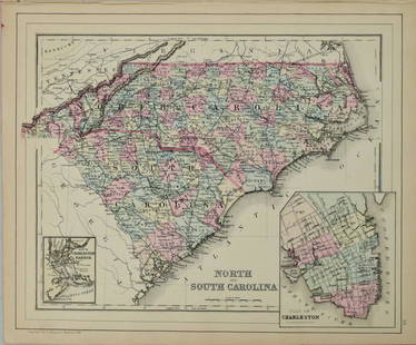
Sold20191867 NORTH + SOUTH CAROLINA MAPOriginal antique map of North and South Carolina published by S. Augustus Mitchell, Jr. Includes inset maps of Charleston Harbor in the bottom left and a Plan of Charleston in the bottom right. It feaSee Sold Price
Sold2016S. Mitchell: North and South Carolina, 1871Map: North and South Carolina Cartographer: S Mitchell Publishing: Philadelphia, 1871 (marked 1850) Size: 11.3 x 14 inches A very nice map of the Carolinas, showing via color-coding the individual couSee Sold Price
Sold2023Emanuel Bowen Map North & South Carolina, Georgia[Emanuel Bowen Map of North & South Carolina and Georgia] , "A New & Accurate Map of the Provinces of North & South Carolina Georgia & c. Drawn from late Surveys and regulated by Astron Observat. By ESee Sold Price
Sold2017Bradford: Antique Map of North/South Carolina & GeorgiaTitle/Content of Map: North & South Carolina with Georgia by Bradford Date Printed: 1835 Cartographer: T.G. Bradford Material/Medium: Paper Size: 13" x 9 1/2" A Comprehensive Atlas Geographical, HistoSee Sold Price
Sold20211796 MAP OF NORTH & SOUTH CAROLINA, DENISON, FRAMEJ. Denison (American, 18th century). "Map of North and South Carolina" -1796, from "Morse's Universal Geography", engraving. Framed. Provenance: From the Lifetime Collection of Billy S. Arant, Jr., ChSee Sold Price
Sold2016Map of North & South Carolina, 1868Original engraving from Johnson's Atlas of the World, 1868. Map includes vignette of the Charleston Harbor & details cities, towns and territories. Dimensions: 18" x 26". This item ships from Ocean ViSee Sold Price
Sold2017Rare 1967 Mouzon Map of North & South Carolinavery limited production by Louis and Clark Explorer Maps LLC in Kitty Hawk, and Charlotte, North Carolina. reproduction gives excellent detail and very well resembles the original map. marked "L&C" atSee Sold Price
5 days LeftBrunk AuctionsJohn Mitchell - A Map of the British and French Dominions in North America, 1755-1757US$24,000
2 days LeftJasper52Novae insulae. The New World. North & South America. SEBASTIAN MÜNSTER 1572 mapUS$5,500
5 days LeftBrunk AuctionsExceptionally Rare Price-Strother Survey of North Carolina Map, c. 1808US$60,000
1 day LeftRapid Estate Liquidators and Auction GalleryVintage North And South Carolina Souvenir Porcelain BellsUS$30
Oct 11Austin Auction Gallery(2) MITCHELL GOLD & BOB WILLIAMS VELVET UPHOLSTERED 'COOPER' CHAIRSUS$300
Oct 11Austin Auction Gallery(2) MITCHELL GOLD + BOB WILLIAMS LEATHER UPHOLSTERED CHAIR & OTTOMAN SETUS$300
Oct 11Austin Auction Gallery(2) MITCHELL GOLD + BOB WILLIAMS LEATHER UPHOLSTERED CHAIR & OTTOMAN SETUS$300
1 day LeftJasper52Map Accompanying Reports of the Artesian Wells Investigation [in North and South Dakota]US$80
2 days LeftJasper52Geological map South Italy, Greece, Albania, North Macedonia. BEYSCHLAG 1898US$300
2 days LeftJasper52London - 1961 South Asian, African & Caribbean immigrant population 1968 mapUS$300
Oct 12JM Hobby Supply and Railroad Artifact AuctionsChicago Duluth and Georgian Bay Transit Company 1932 TimetableUS$20(1 bid)
Oct 26The Written Word AutographsAmericana 1855 ORIGINAL Illinois Railways Land For Sale PamphletUS$50
4 days LeftBrunk AuctionsRare North Carolina Federal Bellflower and Light Wood Inlaid Walnut SideboardUS$7,500
5 days LeftTrillium Antique Prints & Rare BooksVan der Aa - Map of Southern Atlantic Ocean: South America, part of North America, Europe, AfricaUS$75


![Emanuel Bowen Map North & South Carolina, Georgia: [Emanuel Bowen Map of North & South Carolina and Georgia] , "A New & Accurate Map of the Provinces of North & South Carolina Georgia & c. Drawn from late Surveys and regulated by Astron Observat. By E](https://p1.liveauctioneers.com/268/293228/155705053_1_x.jpg?height=310&quality=70&version=1687296979)


![Map Accompanying Reports of the Artesian Wells Investigation [in North and South Dakota] (1 of 4)](https://p1.liveauctioneers.com/5584/343693/186665649_1_x.jpg?height=282&quality=70&version=1726603887)


