Sold2018North Carolina & South Carolina by MitchellTitle/Content of Map: North Carolina & South Carolina by Mitchell Date: 1869 Cartographer: Augustus S. Mitchell Material/Medium: Paper Size: 14" x 16" Provenance: New York Published in Philadelphia inSee Sold Price
Sold2018Two Civil War Era Mitchell MapsMap of North America Showing Its Political Divisions and county maps of North Carolina, South Carolina, and Florida on one sheet (Philadelphia: S. Augustus Mitchell, 1860). Not framed. 15.25 x 12.25 iSee Sold Price
Sold2016S. Mitchell: North and South Carolina, 1871Map: North and South Carolina Cartographer: S Mitchell Publishing: Philadelphia, 1871 (marked 1850) Size: 11.3 x 14 inches A very nice map of the Carolinas, showing via color-coding the individual couSee Sold Price
Sold2019Samuel Augustus Mitchell (1790-1868), "County Map ofSamuel Augustus Mitchell (1790-1868), "County Map of Florida, North Carolina, South Carolina," 1860, H. - 12 1/4 in., W. - 15 3/8 in.See Sold Price
Sold20191867 NORTH + SOUTH CAROLINA MAPOriginal antique map of North and South Carolina published by S. Augustus Mitchell, Jr. Includes inset maps of Charleston Harbor in the bottom left and a Plan of Charleston in the bottom right. It feaSee Sold Price
Sold20221877 Mitchell Map of North and South Carolina -- North and South CarolinaTitle: 1877 Mitchell Map of North and South Carolina -- North and South Carolina Cartographer: S Mitchell Date/Place: 1877 Philadelphia Dimensions: 10.5 x 13.5 in. Description: This is an excellent anSee Sold Price
Sold20211887 Mitchell Map of North and South Carolina -- NorthTitle: 1887 Mitchell Map of North and South Carolina -- North and South Carolina Cartographer: S Mitchell Year / Place: 1887, Philadelphia Map Dimension (in.): 11.3 X 14 in. A very nice map of the CarSee Sold Price
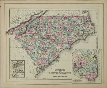
Sold20211884 Mitchell Map of North and South Carolina -- NorthTitle: 1884 Mitchell Map of North and South Carolina -- North and South Carolina Cartographer: S Mitchell Year / Place: 1884, Philadelphia Map Dimension (in.): 11.3 X 14 in. This is a very nice map ofSee Sold Price
Sold20231891 Mitchell Map of Maryland, Virginia, North Carolina and South Carolina -- Map of Maryland,Title: 1891 Mitchell Map of Maryland, Virginia, North Carolina and South Carolina -- Map of Maryland, Virginia, North Carolina and South Carolina Cartographer: S Mitchell Year/Place: 1891, PhiladelphiSee Sold Price
Sold20181876 Mitchell Map of North and South Carolina -- NorthReserve Reduced! Title/Content of Map: 1876 Mitchell Map of North and South Carolina -- North and South Carolina Date: 1876 Philadelphia Cartographer: S Mitchell Size: 10.5 x 13.5 in. Excellent and hiSee Sold Price
Sold20181867 Mitchell Map of North and South Carolina -- CountyTitle/Content of Map: 1867 Mitchell Map of North and South Carolina -- County Map of North and South Carolina Date: 1867, Philadelphia Cartographer: S Mitchell Size: 11.5 x 13.8 in. This is a handsomeSee Sold Price
Sold2019Eight (8) Augustus Mitchell MapsCollection of eight maps including New Jersey/Maryland Delaware 1872, Two north and South Carolina 1872 maps (15" x 12"), Minnesota 1890 , Florida and the Carolinas 1860, County map of the state of ArSee Sold Price
Sold20201860 Mitchell Map of Florida, South and North CarolinaTitle/Content of Map: 1860 Mitchell Map of Florida, South and North Carolina -- County Map of Florida on page with Map of South Carolina, on page with County Map of North Carolina Cartographer: S MitcSee Sold Price
Sold20231860 Mitchell Map of Florida, South and North Carolina -- County Map of Florida on page with Map ofTitle: 1860 Mitchell Map of Florida, South and North Carolina -- County Map of Florida on page with Map of South Carolina, on page with County Map of North Carolina Cartographer: S Mitchell Year / PlaSee Sold Price
Sold20211860 Mitchell Map of Florida, South and North CarolinaTitle: 1860 Mitchell Map of Florida, South and North Carolina -- County Map of Florida on page with Map of South Carolina, on page with County Map of North Carolina Cartographer: S Mitchell Year / PlaSee Sold Price
Sold2017Mitchell Map of Florida, South and North Carolina, 1860Title: 1860 Mitchell Map of Florida, South and North Carolina Cartographer: S Mitchell Published: 1860, Philadelphia Measurements: 10.6 X 13.5 in. County Map of Florida on page with Map of South CarolSee Sold Price
Sold20181863 Mitchell Map of Florida, South and North CarolinaTitle/Content of Map: 1863 Mitchell Map of Florida, South and North Carolina -- County Map of Florida on page with Map of South Carolina, on page with County Map of North Carolina Date: 1863, PhiladelSee Sold Price
Sold20181860 Mitchell Map of Florida, South and North CarolinaTitle/Content of Map: 1860 Mitchell Map of Florida, South and North Carolina -- County Map of Florida on page with Map of South Carolina, on page with County Map of North Carolina Date Printed: 1860,See Sold Price
Sold20201860 Mitchell Map of Florida, South and North CarolinaTitle/Content of Map: 1860 Mitchell Map of Florida, South and North Carolina -- County Map of Florida on page with Map of South Carolina, on page with County Map of North Carolina Date: 1860, PhiladelSee Sold Price
Sold2022PURCELL, JOSEPH A Map of the States of Virginia North Carolina South Carolina and GeorgiaPURCELL, JOSEPH A Map of the States of Virginia North Carolina South Carolina and Georgia Comprehending the Spanish Provinces of East and West Florida... New Haven: Amos Doolittle, 1788. Engraved mapSee Sold Price
Sold2021Map of Part of Virginia, North Carolina, South CarolinaPublication Date: c1865Title: Map of Part of Virginia, North Carolina, South Carolina & Georgia Cartographer: KEMBLE, W. Publisher: VIRTUE, EMMINS & CO. Height: 9 Width: 5.5 "which were the scenes ofSee Sold Price
Sold201918th c. Purcell Map, "State of Franklin"Joseph Purcell: A MAP OF THE STATES OF VIRGINIA, NORTH CAROLINA, SOUTH CAROLINA, AND GEORGIA; Comprehending the SPANISH PROVINCES of EAST AND WEST FLORIDA. Scarce Edinburgh, Scotland imprint, circa 17See Sold Price
Sold2023Atlantic Coast Line VignetteVirginia - North Carolina - South Carolina - Georgia - Florida - Alabama 12" paper dial ca. 1900 Providence Jerry Wealti. Delavan, Wisconsin. Long-time member of the NAWCC (National Antique Watch & ClSee Sold Price
Sold2017JOSEPH PURCELL (AMERICAN) MAP OF THE SOUTHEASTERNJOSEPH PURCELL (AMERICAN) MAP OF THE SOUTHEASTERN UNITED STATES, titled "A Map of the States of Virginia North Carolina South Carolina and Georgia, Comprehending the Spanish Provinces of East and WestSee Sold Price
May 23South Florida Auction & Estate Sale Services Inc1875 Lab Tested 24k Gold Clad $100 BanknoteUS$6
3 days LeftFreeman's | HindmanGuy Arthur Wiggins (American, 1920-2020) The East River from the South Street SeaportUS$2,500
12 hrs LeftBK AuctionsDecember 23 1776 $8 South Carolina Colonial Note Fr. SC-141 PMG About Uncirculated 55US$1(1 bid)
May 31Freeman's | Hindman[CIVIL WAR - SOUTH CAROLINA ACT OF SECESSION]. An Ordinance. To dissolve the Union between the StateUS$7,500
Jun 08Potter & Potter Auctions“Okito” Money Maker. South Carolina: Algonquin McDuff (Rhett Bryson), ca. ...US$125


![[CIVIL WAR - SOUTH CAROLINA ACT OF SECESSION]. An Ordinance. To dissolve the Union between the State (1 of 2)](https://p1.liveauctioneers.com/197/329785/177758237_1_x.jpg?height=282&quality=70&version=1715625218)

