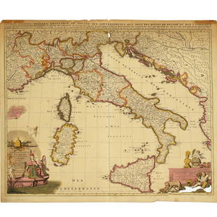
Sold2022Nicolas Sansom, map of Italy, 1701Nicolas Sansom, map of Italy, 1701, "L'Italie Divisee Suivant l'Estendue de Toutes ses Sourverainetes…", Pieter Schenk, Amsterdam, 1701, hand-colored copper plate engraving on laid paper, 20.25"See Sold Price
Sold2021Nicolas Sansom, map of Italy, 1701Nicolas Sansom, map of Italy, 1701, "L'Italie Divisee Suivant l'Estendue de Toutes ses Sourverainetes…", Pieter Schenk, Amsterdam, 1701, hand-colored copper plate engraving on laid paper, 20.25"See Sold Price
Sold2024Adam Friedrich Zurner (German 1679 - 1742) and Peter Schenk (German 1660 - 1711)Adam Friedrich Zurner (German 1679 - 1742) and Peter Schenk (German 1660 - 1711) "Americae tam Septentionalis quam Meridionalis in Mappa Geographica Delineato", circa 1709 Hand colored map engraving 2See Sold Price
Sold2021Early Hand-colored Maps17th- 19th c hand-colored maps ( pcs), including Ortelius "Transsylvaniae", Pieter van der Keere "Lancastria", Rapkin "Egypt and Arabia Petraea" Grassl "Californien, Texas", Rapkin "China & Burma", ovSee Sold Price
Sold2020Henricus Hondius 1650 Map of America(Amsterdam, 1597-1651) Very nicely detailed hand colored map of the US of the period predating that of Petrus Schenk. The piece has exceptional colors and has been professionally framed and acid freeSee Sold Price
Sold20211650 Insularum Archipelagi Septentrion Alis Seu MarisBy: Jan JanssonDate: 1650 (circa) AmsterdamDimensions: 18.75 x 22.25 inches (48 cm x 57 cm)This authentic antique hand-colored map by Jan Jansson depicts the Northern Archipelago in Greece with the AeSee Sold Price
Sold2022(MEXICO.) Henry Schenk Tanner. A Map of the United States of Mexico,(MEXICO.) Henry Schenk Tanner. A Map of the United States of Mexico, As Organized and Defined by the Several Acts of Congress of that Republic. Large hand-colored lithographed map of southwestern NortSee Sold Price
Sold2016ANTIQUE NEW-FRANCE HAND COLORED MAPANTIQUE NEW-FRANCE HAND COLORED MAP, H 27 1/2" IMAGE, W 20 1/2":Framed, measures H.30" x 23" overall.See Sold Price
Sold2024Matthaus Merian 1627 Antique Hand Colored Map "Virginia" from Theodore de Bry's "Grand Voyages" #2Antique 1627 hand-colored map of Virginia by Matthaus Merian after John Smith's 1612 map, from Theodore de Bry's "Grand Voyages". Good condition overall, with age-appropriate wear, repairs (see photosSee Sold Price
Sold20161666 Original Hand Colored Map of Virginiaapprox 21" X 17"...... Pas Caerte van Nieu Nederlandt en de Engelsche Virginies, van Cabo Cod tot Cabo Canrick. (Chart of New Netherland and the English Virginias from Cape Cod to Cape Canrick [i.e. HSee Sold Price
Sold2024Henricus Hondius 1630 "Nova Virginiae Tabula" Hand Colored Map of Virginia and Chesapeake #1Antique, original hand-colored map of Virginia and the Chesapeake Bay originally by Henricus Hondius in 1630 titled "Nova Virginiae Tabula". With French text on reverse final catchword "n'en" and signSee Sold Price
Sold2024John Speed 1676 Antique Hand Colored "Map of Virginia and Maryland" #2Antique 1676 hand-colored map of Virginia and Maryland engraved by Francis Lamb and republished by Thomas Basset & Richard Chriswell after John Speed's 1611 atlas. Good overall, apparent repairs, minoSee Sold Price
Sold2020F. B. Werner, "Roma" hand-colored map, 1730F. B. Werner, "Roma" hand-colored map, 1730, Panoramic view of Rome, hand-colored engraving on laid paper, no watermark observed, two sheets joined at center, marked "F. B. Werner delin Ao 1730" and "See Sold Price
Sold2024Very Rare Mexico Nova Hispania 1579 Hand Colored MapORTELIUS, Abraham (1527-1598). Theatrum Orbis Terrarum. 1570. It is considered to be the first modern atlas. Map of New Spain (Mexico), 1579. Printed in Antwerp by Christophe Plantin (1588). Etching.See Sold Price
Sold2021Hand colored map, Africa. 23” x 20.5”Hand colored map, Africa. 23” x 20.5”See Sold Price
Sold2020Small Hand-Colored Map of Nantucket by William SchontzeSmall Hand-Colored Map of Nantucket by William Schontzeler,rare pictorial map of Nantucket in original frame, signed, l.r William Cotton Schontzeler, trained as a draftsman in NY, he owned and workedSee Sold Price
Sold2021French Hand-Colored Map of America, 1750Antique French Hand-Colored Map of America , "Amerique Septentrionale, dressee, sur les Relations les plus modernes...", 1750, Robert de Vaugondy, the cartouche with an alligator flanked by figures, 1See Sold Price
Sold2023Antique Hand Colored Map of the Western Part of CanadaAntique Hand Colored Map of the Western Part of CanadaNice hand colored engraved on paper an antique, 1755 map of the western part of New France or Canada by M. Bellin, Engineer of the king. FeaturingSee Sold Price
Sold2018GEORG BRAUN & FRANS HOGENBERG HAND COLORED MAPGEORG BRAUN & FRANS HOGENBERG HAND COLORED DOUBLE-PAGE ENGRAVED MAP, H 13 1/4", W 19", "LUTETIA, VULGARI NOMINE PARIS":DEPICTING 16TH CENTURY PARIS, WITH A DECORATIVE TITLE-CARTOUCHE FEATURING COAT OFSee Sold Price
Sold2022Hand-Colored MapsHand-Colored Maps (2) items including a posthumous printing of John Speed 'A New Mappe of the Romane Empire' including original invoice from George Ritzlin Maps & Prints, depicting the areas encompassSee Sold Price
Sold2024Gerard Mercator (Belgian 1512 - 1594) and Rumold Mercator (Belgian 1545 - 1599)Gerard Mercator (Belgian 1512 - 1594) and Rumold Mercator (Belgian 1545 - 1599) "Orbis Terrae Compendiosa Descriptio", circa 1595 Engraved and hand colored map 14 1/2" x 19 3/4" Condition: aging, yellSee Sold Price
Sold2024Abraham Ortelius (Belgian 1527 - 1598)Abraham Ortelius (Belgian 1527 - 1598) "Maris Pacifici", circa 1603 Hand Colored map engraving of the Pacific Ocean 14" x 20" Condition: aging, yellowing to paper, undulation, center folds, some fadinSee Sold Price
Sold2022Brassier A Survey of Lake ChamplainWilliam Brassier "A Survey of Lake Champlain", Sayer and Bennett, London, 1776 hand-colored map, plate size 26 1/2" x 19 1/4"See Sold Price
Sold2022(WEST--TEXAS.) [George F. Folsom.] Mexico in 1842 . . . to which is Added, an Account of Texas and(WEST--TEXAS.) [George F. Folsom.] Mexico in 1842 . . . to which is Added, an Account of Texas and Yucatan. Folding hand-colored map. 256 pages. 12mo, publisher's cloth, minor wear; minor foxing; earlSee Sold Price
BonhamsCELLARIUS, ANDREAS. 1596-1665. Harmonia macrocosmica seu atlas universalis et novus, totius uni...US$18,000(3 bids)
BonhamsCELLARIUS, ANDREAS. 1596-1665. Corporum Coelestium Magnitudines. Amsterdam: Schenk and Valk, c.1...US$700(9 bids)
BonhamsCELLARIUS, ANDREAS. 1596-1665. Scenographia Compagis Mvndanae Brahea. Amsterdam: Schenk and Valk...US$550(9 bids)
BonhamsCELLARIUS, ANDREAS. 1596-1665. Planisphaerivm Ptolemaicvm Sive Machina Orbivm Mvndi. Amsterdam: ...US$950(11 bids)
2 hrs LeftFreeman's | Hindman[Maps & Atlases] Seutter, Matth(ias).: Novus Orbis sive America...US$300(1 bid)
2 days LeftA.H. Wilkens Auctions & AppraisalsA PLAN OF THE FORT AND BAY OF FRONTENAC (1758)CA$150(1 bid)
2 hrs LeftFreeman's | Hindman[Maps & Atlases] Braun, Georg, and Frans Hogenberg: Londinum, Feracissimi Angliae...US$1,000
2 days LeftA.H. Wilkens Auctions & AppraisalsJEFFERYS. AN EXACT CHART OF THE RIVER ST. LAURENCECA$200(1 bid)
1 day LeftDOYLE Auctioneers & AppraisersAn eighteenth-century map of Nîmes in Southern France, with views of its Roman monumentsUS$100(1 bid)
3 days LeftSwann Auction Galleries(WEST--TEXAS.) David B. Edward. The History of Texas; or, The Emigrant's, Farmer's, and Politician'sUS$1,500
2 days LeftA.H. Wilkens Auctions & AppraisalsBOWEN. A NEW & ACCURATE MAP OF THE ISLANDS (1747)CA$225(2 bids)
5 days LeftAntique FactoryJOHN SPEED (1552 - 1629), BUCKINGHAM 17th Century Copper Engraving Hand Colored Town Plan MapUS$200


![(WEST--TEXAS.) [George F. Folsom.] Mexico in 1842 . . . to which is Added, an Account of Texas and: (WEST--TEXAS.) [George F. Folsom.] Mexico in 1842 . . . to which is Added, an Account of Texas and Yucatan. Folding hand-colored map. 256 pages. 12mo, publisher's cloth, minor wear; minor foxing; earl](https://p1.liveauctioneers.com/199/242021/125450317_1_x.jpg?height=310&quality=70&version=1648143591)


![[Maps & Atlases] Speed, John: The Turkish Empire (1 of 2)](https://p1.liveauctioneers.com/65/332523/179335176_1_x.jpg?height=282&quality=70&version=1717709446)
![[Maps & Atlases] Speed, John: Spaine (1 of 2)](https://p1.liveauctioneers.com/65/332523/179335175_1_x.jpg?height=282&quality=70&version=1717709446)
![[Maps & Atlases] Seutter, Matth(ias).: Novus Orbis sive America... (1 of 2)](https://p1.liveauctioneers.com/65/332523/179335174_1_x.jpg?height=282&quality=70&version=1717709447)


![[Maps & Atlases] Braun, Georg, and Frans Hogenberg: Londinum, Feracissimi Angliae... (1 of 3)](https://p1.liveauctioneers.com/65/332523/179335170_1_x.jpg?height=282&quality=70&version=1717622830)


