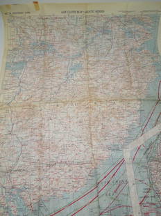
Sold2023Three USAF Cloth Escape Maps.Three USAF Cloth Escape Maps. Double Sided - Gulf of Bothnia and White Sea. In-house shipping available. Pickup is Tuesday, April 11th from 10am to 4pm in Carroll, Ohio 43112 or we will provide in-houSee Sold Price
Sold2023RARE WWII British Cloth Escape Maps European Theater 1943 Series #43 E/F.WWII British Cloth Escape Maps European Theater 1943 Series #43 E/F. This Silk map is in Excellent Condition as pictured. Side E has maps of Germany Protectorate, Slovakia, Poland, and Hungary while SSee Sold Price
Sold2023RARE WWII British Cloth Escape Maps European Theater 1943 Series #43 C/D.WWII British Cloth Escape Maps European Theater 1943 Series #43 C/D. This Silk map is in Excellent Condition as pictured. Side C has maps of Holland, Belgium, France and Germany while Side D has mapsSee Sold Price
Sold20245 U.S. fighter pilot East Asia escape cloth mapsHeading: (China - World War II escape map) Author: Title: Five US Army Air Force pilot silk escape maps of East Asia from World War II Place Published: Washington, D.C. Publisher:Army Map Service, U.See Sold Price
Sold20245 U.S. fighter pilot China-Japan escape cloth mapsHeading: (China - World War II escape map) Author: Title: Five US Army Air Force pilot silk escape maps of China and Japan from World War II Place Published: Washington, D.C. Publisher:Army Map ServiSee Sold Price
Sold2019Group of Three WWII U.S. Pilot Escape Silk Maps, "Group of Three WWII U.S. Pilot Escape Silk Maps, " Amsterdam, Hamburg, Berlin, Warsaw on reverse Vilnyus, and Minsk," H. - 24 in., W. - 30 in.; " Stalingrad on reverse Stepnoy," H. - 22 in., W. - 20 iSee Sold Price
Sold2023WWII 1943 USAAF Army Air Force Silk Pilot Escape Officers Cloth Map of ChinaWWII 1943 AAF Southeast China Cloth Silk Officers Map. This map was part of the Asiatic Series. The approximate size is 20 x 27 inches. Excellent condition with tape residue and a chemical type smellSee Sold Price
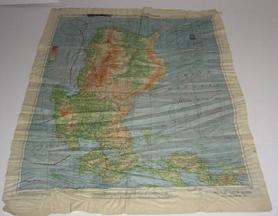
Sold20191945 US Army Escape Silk Map of Northern Sumatra/MalayTitle/Content of Map: 1945 US Army Escape Silk Map of Northern Sumatra/Malay Peninsula [verso] Central Sumatra -- [Escape Silk Map] C800 [verso] C920 Cloth Chart Date: 1945, Washington DC CartographerSee Sold Price
Sold2017WWII Pilot Escape Survival map handkerchief map1944 AAF Cloth Chart Philippine series silk double sided WWII Pilot Escape Survival handkerchief map. Foxing/stains. 20 inches x 25 inches.See Sold Price
Sold2020The West of William H. Ashley by Morgan 1964 LTDThe West of William AH. Ashley 1822-1838 edited by Dale L. Morgan. Signed and numbered '194' of 250 copies. 1964. 341 pp. Illustrated. Fold-out map in back. Cloth covers with half-leather and three raSee Sold Price
Sold2020Lord of the Rings Trilogy Second Edition Book SetAll three books are black cloth hard covers with colored emblems on front. Each is Second Edition and Third Printing. All maps are in the back and appear to be in clean condition. Pages are free of anSee Sold Price
Sold2021Lord of the Rings Trilogy Second Edition Book SetAll three books are black cloth hard covers with colored emblems on front. Each is Second Edition and Third Printing. All maps are in the back and appear to be in clean condition. Pages are free of anSee Sold Price
Sold2018Mitchell’s New Reference Atlas.[Maps] Mitchell’s New Reference Atlas. Philadelphia: E.H. Butler & Co., 1865. Three-quarter leather over maroon cloth, gilt-stamped cover, gilt title on banded spine, marbled endpapers. Fifty-siSee Sold Price
Sold2021Alan Moorehead. Three Titles.A three book selection by Alan Moorehead. All in original pictorial dust-jackets.[small repairs]. Book One. "The White Nile" 1960. Publishers red cloth with gilt title to spine. Map endpapers. Name onSee Sold Price
Sold2020Three WWII Movement MapsThree WWII Movement Maps including VII Corps , XIX Corps in action from Siegfried line to Victory. Together with "American Expeditionary Forces, Distinctive Cloth Insignia" poster. Used condition, weaSee Sold Price
Sold2017My African Journey, Winston Churchill, 1908My African Journey: With Sixty-one Photographs by the Author and Lieutenant-colonel Gordon Wilson, and Three Maps churchill, Winston Spencer hodder & Stoughton, London, 1908 Red pictorial cloth stampeSee Sold Price
Sold2016[Africa, War, Lot of 5]Including: ***** 1: Buchanan. THREE YEARS OF WAR IN EAST AFRICA. London, 1920. 2nd printing. Maps and plates present as per list. 8vo rebound in modern cloth. Very Good. ***** 2: Farago. ABYSSINIA ONSee Sold Price
Sold2020Lewis and Clarke Journals 1922 (3V)History of the Expedition under the Command of Captains Lewis and Clarke in three volumes. 1922 with illustrations and maps. Allerton Book Co., New York. 416 pp. plus 410 pp. plus 582 pp. Brown clothSee Sold Price
Sold2024Peaks and LamasFourth edition. Publishers blue cloth with blind-stamped vignette. Gilt title to spine. Colour top page-block. With one plate in colour, ninety-five photogravure illustrations, and three maps. "A fascSee Sold Price
Sold2020Three maps, late 18th-early 19th centuryThree mapslate 18th-early 19th centuryComprising a French hand-colored copperplate map of Virginia, 1760-1762; a map of the United States, 1719, by H.A. Chatelain, Amsterdam; and a map of Delaware, 18See Sold Price
Sold2022Three Maps of North America, One World MapFour maps, including: Robert Wilkinson, The United States of America Confirmed By Treaty 1783, London, circa 1800-1812, engraving on wove paper; L'Amerique Septentrionale, "Terres vues par Tchirikov 1See Sold Price
Sold2023THREE MAPS OF MAINE 19th CenturyTHREE MAPS OF MAINE19th Century1) J.J. Stoner map of Thomaston. Framed 20.25” x 28”.2) E.M. Woodford 1855 rolled map of Thomaston Village. Approx. 47” x 39”.3) Lee & Marsh 1857See Sold Price
Sold2019Three Maps by Franz Ludwig Güssefeld (1744-1808),Three Maps by Franz Ludwig Güssefeld (1744-1808), "Charte Uber DIE XIII Vereinigten Staaten Nord America," 1784,hand colored, H. - 18 1/2 in., W. - 23 1/2 in. (3 Pcs.)See Sold Price
Sold2019Three Maps by Matthiae Hasii (Homann Heirs),"AmericaeThree Maps by Matthiae Hasii (Homann Heirs),"Americae Mappa Generalis," 1746, hand colored, H.- 19 1/4 in., W.- 22 1/4 in., (3 Pcs.)See Sold Price
BonhamsASHENDENE PRESS The Wisdom of Jesus, the Son of Sirach Commonly Called Ecclesiasticus, Ashendene...£1,000
7 days LeftJasper521910 TRANS-HIMALAYA DISCOVERIES & ADVENTURES in TIBET antique ILLUSTRATED 3 volsUS$480
3 days LeftTrillium Antique Prints & Rare BooksJournal des Dames et des Modes - Four Volumes with 186 Pochoir Fashion PlatesUS$1,000
BonhamsSCOTTISH NATIONAL ANTARCTIC EXPEDITION, 1902-1904 [BROWN (ROBERT NEAL RUDMOSE, etc.) The Voyage ...£500
7 days LeftJasper521694 de Fer Three Maps of the Versailles Canal (Not Completed) -- I., II., III., Partie du NouveauUS$120
7 days LeftJasper521581 Ortelius Map of Tuscany [with] Corsica [with] Ancona -- Senensis Ditionis, Accurata Descrip [onUS$140
Jun 08Potter & Potter AuctionsGOLDSTON, Will (1878 – 1948). The Magician Annual. Five Vol...US$200
Jun 08Simpson Galleries, LLC.HENRY MILLER (American 1891-1980) AND BEZALEL SCHATZ (Palestinian 1912-1978) A GROUP OF PRINTS ANDUS$150
BonhamsMILITARY [Army List] A List of the General and Field Officers, as they Rank in the Army; of the ...£10
7 days LeftJasper521902 Cram Map of New York City [verso] Washington DC [verso] Baltimore -- New York [verso]US$60
7 days LeftJasper521760 Bonne Map of Reunion (Bourbon), Mauritius (I. de France) and Rodrigue(s) -- CartesUS$80
BonhamsMARKHAM (CLEMENTS) The Land of Silence: A History of Arctic and Antarctic Exploration, FIRST EDI...£10


![1945 US Army Escape Silk Map of Northern Sumatra/Malay: Title/Content of Map: 1945 US Army Escape Silk Map of Northern Sumatra/Malay Peninsula [verso] Central Sumatra -- [Escape Silk Map] C800 [verso] C920 Cloth Chart Date: 1945, Washington DC Cartographer](https://p1.liveauctioneers.com/5584/134050/68048822_1_x.jpg?height=310&quality=70&version=1546996032)


![Mitchell’s New Reference Atlas.: [Maps] Mitchell’s New Reference Atlas. Philadelphia: E.H. Butler & Co., 1865. Three-quarter leather over maroon cloth, gilt-stamped cover, gilt title on banded spine, marbled endpapers. Fifty-si](https://p1.liveauctioneers.com/928/124137/63148814_1_x.jpg?height=310&quality=70&version=1530051387)
![Alan Moorehead. Three Titles.: A three book selection by Alan Moorehead. All in original pictorial dust-jackets.[small repairs]. Book One. "The White Nile" 1960. Publishers red cloth with gilt title to spine. Map endpapers. Name on](https://p1.liveauctioneers.com/5584/209856/106821906_1_x.jpg?height=310&quality=70&version=1625608762)


![[Africa, War, Lot of 5]: Including: ***** 1: Buchanan. THREE YEARS OF WAR IN EAST AFRICA. London, 1920. 2nd printing. Maps and plates present as per list. 8vo rebound in modern cloth. Very Good. ***** 2: Farago. ABYSSINIA ON](https://p1.liveauctioneers.com/3532/95081/48483456_1_x.jpg?height=310&quality=70&version=1476656219)


![FLEMING (IAN) For Your Eyes Only, FIRST EDITION, FIRST IMPRESSION, Jonathan Cape, [1960] (1 of 3)](https://p1.liveauctioneers.com/1043/319451/178359340_1_x.jpg?height=282&quality=70&version=1716975314)


![1581 Ortelius Map of Tuscany [with] Corsica [with] Ancona -- Senensis Ditionis, Accurata Descrip [on (1 of 1)](https://p1.liveauctioneers.com/5584/331064/178466435_1_x.jpg?height=282&quality=70&version=1716924723)


![MILITARY [Army List] A List of the General and Field Officers, as they Rank in the Army; of the ... (1 of 2)](https://p1.liveauctioneers.com/1043/319451/178359174_1_x.jpg?height=282&quality=70&version=1716975271)
![1902 Cram Map of New York City [verso] Washington DC [verso] Baltimore -- New York [verso] (1 of 3)](https://p1.liveauctioneers.com/5584/331064/178466310_1_x.jpg?height=282&quality=70&version=1716924723)


![[Geneva Bible] (1 of 1)](https://p1.liveauctioneers.com/94/330664/178342142_1_x.jpg?height=282&quality=70&version=1716466933)

![[The Philippines] - Algué, P. José [Henry S. Pritchett] (1 of 1)](https://p1.liveauctioneers.com/94/330664/178342475_1_x.jpg?height=282&quality=70&version=1716466933)