Sold20245 U.S. fighter pilot China-Japan escape cloth mapsHeading: (China - World War II escape map) Author: Title: Five US Army Air Force pilot silk escape maps of China and Japan from World War II Place Published: Washington, D.C. Publisher:Army Map ServiSee Sold Price
Sold20245 U.S. fighter pilot East Asia escape cloth mapsHeading: (China - World War II escape map) Author: Title: Five US Army Air Force pilot silk escape maps of East Asia from World War II Place Published: Washington, D.C. Publisher:Army Map Service, U.See Sold Price
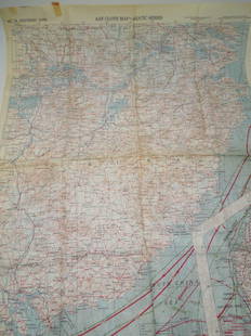
Sold2023WWII 1943 USAAF Army Air Force Silk Pilot Escape Officers Cloth Map of ChinaWWII 1943 AAF Southeast China Cloth Silk Officers Map. This map was part of the Asiatic Series. The approximate size is 20 x 27 inches. Excellent condition with tape residue and a chemical type smellSee Sold Price
Sold20234 WWII Silk Pilots Escape or Invasion MapsGroup of 4 World War II era silk Air Force pilots escape maps, one of Sicily and Italy, Ryojun, Manchuria/Pei-P'Ing China, Otomari, Japan/Vladimiro-Aleksandrovskoye, Greece/Bulgaria-Romania 15" x 19"-See Sold Price
Sold2016Nagasaki pilot's escape map 1944Heading: (Japan) Author: Title: Nagasaki [&] Kagoshima Place Published: Washington, D.C. Publisher:Army Map Service Date Published: 1944 Description: Color maps, printed onSee Sold Price
Sold2020WWII 1943 British East Anglia Air Force Map24 inch x 29.5 inch map of East Anglia produced by the British War Office and used by RAF and US Pilots. This one belonged to Brigadier General Jesse Auton, Cpommander of an 8th AAF Fighter Wing in WWSee Sold Price
Sold2020WWII 1942 British East Anglia Air Force Map24 inch x 29.5 inch map of East Anglia produced by the British War Office and used by RAF and US Pilots in 1942. This one belonged to Brigadier General Jesse Auton, Cpommander of an 8th AAF Fighter WiSee Sold Price
Sold2019Group of Three WWII U.S. Pilot Escape Silk Maps, "Group of Three WWII U.S. Pilot Escape Silk Maps, " Amsterdam, Hamburg, Berlin, Warsaw on reverse Vilnyus, and Minsk," H. - 24 in., W. - 30 in.; " Stalingrad on reverse Stepnoy," H. - 22 in., W. - 20 iSee Sold Price
Sold2018Vintage Hankie CollectionApprox. 40 vintage hankies including needlework, Pan American 1901, printed children's hankies, cloth maps of Japan and South China Sea and more.See Sold Price
Sold2023WWII - Later Stereoscope Glasses, Magazines, US Navy Photos, Maps, Booklets Ephemera LotYou are bidding on the following: Stereoscope Glasses Type I (Astrodyne, Inc), WWII Era Pearl Harbor Bulletin Magazines, Ship Photos, 1944 Honolulu Harlot booklet, China / Japan maps, Confidential copSee Sold Price
Sold20181943 US Air Force Silk Escape Map of Northern HonsuTitle/Content of Map: 1943 US Army Air Force Silk Escape Map of Northern Honsu (main island) and Hokkado Islands, Japan -- [Escape Silk Map] Hakodate [verso] Nemuro Date Printed: 1943, Washington DC CSee Sold Price
Sold2018Antique 19th C Victorian China Japan Korea MapAntique 19th C Victorian China Japan Korea Map & North Pole Map. Printed by J Martin Miller. Measures 16.5 x 22.5 inches.See Sold Price
Sold2022Times Atlas 1895 Pair of Maps. China & JapanLithograph Maps Published 1895, London for "The Times Atlas" Paper Size: 16 x 10.5 inch (41 x 27cm) Good ConditionSee Sold Price
Sold2021Set 10 NORITAKE Porcelain DishesSet 10 NORITAKE Porcelain Dishes, stamps read ‘NORITAKE China Japan Carmela US Design Pat 95635’, all measure 5 1/4 inches in diameter, surface wear and chips to some pieces, NORITAKE, porcelain,See Sold Price
Sold2024EAST ASIA. Eastern China Central Japan Korea. BARTHOLOMEW 1898 old antique mapTITLE/CONTENT OF MAP: 'Eastern China & Central Japan; Inset map of Tokio; Tozando' DATE PRINTED: 1898 IMAGE SIZE: Approx 43.5 x 32.5cm, 17 x 12.75 inches (Large); Please note that this is a folding maSee Sold Price
Sold2022Cold War US Military Defense Aviation Pilot Maps LotCold War US Military Defense Aviation Pilot Maps Lot. Lot of 5 maps. You will receive the following maps: Global Navigation and Planning Chart GNC 26N, GNC 2, GNC 4, GNC 6 and GNC 8. Prepared and publSee Sold Price
Sold20201782 Bayly Map of China, Japan, Korea -- A New Map ofTitle/Content of Map: 1782 Bayly Map of China, Japan, Korea -- A New Map of China, By J. Bayly, Geographer Cartographer: J Bayly Year/Place: 1782, London Size: 8.7 X 12.5 in. This is a rather attractiSee Sold Price
2017Johnston: Antique Map of China & Japan, 1879Title/Content of Map: 'China and Japan [inset: Islands of Japan]' Date Printed: 1879 Image Size: Approx 47.5 x 61.0cm, 18.75 x 24 inches (Large); Please note that this is a folding map. Type: Large, fSee Sold Price
Sold2019Keith Johnston Edinburgh Map of JAPAN and CHINAKeith Johnston Edinburgh Map of JAPAN and CHINA. Engraved and printed by W & AK Johnston Edinburgh & London. Approx. 24" x 19.5" and in good, age appropriate condition as shown, see photos.See Sold Price
Sold20191945 US Army Escape Silk Map of Northern Sumatra/MalayTitle/Content of Map: 1945 US Army Escape Silk Map of Northern Sumatra/Malay Peninsula [verso] Central Sumatra -- [Escape Silk Map] C800 [verso] C920 Cloth Chart Date: 1945, Washington DC CartographerSee Sold Price
Sold2017Mallet: Map of 'Asie Moderne', 1683TITLE OF THE MAP: 'Asie Moderne, India China Japan Arabia Persia (Iran).' DATE PRINTED: 1683 IMAGE SIZE: Approx Overall page size 13 x 21cm approximately (5 x 8 inches); image size 10.5 x 14.5cm approSee Sold Price
Sold20201899 Map of the Empires of China, Japan and KoreaAuthor: Miller Title: 1899 Map of the Empires of China, Japan and Korea Medium: Ink on Paper Dimensions: 16.5"X11" Map of the empires of China, Japan and Korea dated 1899. Published by J. Martin MilleSee Sold Price
Sold2024ASIA. Siberia Central China India Arabia Indochina Siam Japan Persia 1903 mapTITLE/CONTENT OF MAP: 'Asia with special reference to Siberia and Central Asia' DATE PRINTED: 1903 IMAGE SIZE: Approx 28.5 x 40.0cm, 11.25 x 15.75 inches (Large); Please note that this is a folding maSee Sold Price
Sold2020China, Japan, Korea & East Indies 1903 Lot of 3 MapsLithograph Maps Published 1903 by Adam & Charles Black, Edinburgh & London for "Encyclopaedia Brittannica" Tenth Edition. Centre fold as published. Paper Size: 16 x 11.5 inch (41 x 29cm) Good ConditioSee Sold Price
3 days LeftJasper521896 STANFORD'S COMPEDIUM of GEOGRAPHY & TRAVEL ASIA 2 VOLS. antique ILLUSTRATEDUS$220
3 days LeftJasper521869 MALAY ARCHIPELAGO by A.WALLACE antique illustrated w /MAPS 1st US EDITIONUS$480
May 30NY Elizabeth FIRST US EDITION OF 1869 MALAY ARCHIPELAGO BY A.WALLACE, ANTIQUE ILLUSTRATED WITH MAPSUS$50(1 bid)
May 21BonhamsMaharajah Jagatjit Singh of Kapurthala, My Travels in China, Japan and Java, 1903 Hutchinson & C...£1,200
May 18Blackstone Valley Auctions & Estates LLCWWII Era U.S. Army 11th Airborne Patches & Wings.US$150
Jun 08RbfineartsA Fine And Important Chinese Carved Wood Sculpture Depicting 6 Figures Kwan Yin EtcUS$160(3 bids)


![Nagasaki pilot's escape map 1944: Heading: (Japan) Author: Title: Nagasaki [&] Kagoshima Place Published: Washington, D.C. Publisher:Army Map Service Date Published: 1944 Description: Color maps, printed on](https://p1.liveauctioneers.com/642/89389/45684047_1_x.jpg?height=310&quality=70&version=1464736315)


![1943 US Air Force Silk Escape Map of Northern Honsu: Title/Content of Map: 1943 US Army Air Force Silk Escape Map of Northern Honsu (main island) and Hokkado Islands, Japan -- [Escape Silk Map] Hakodate [verso] Nemuro Date Printed: 1943, Washington DC C](https://p1.liveauctioneers.com/5584/117342/60336934_1_x.jpg?height=310&quality=70&version=1520389291)


![Johnston: Antique Map of China & Japan, 1879: Title/Content of Map: 'China and Japan [inset: Islands of Japan]' Date Printed: 1879 Image Size: Approx 47.5 x 61.0cm, 18.75 x 24 inches (Large); Please note that this is a folding map. Type: Large, f](https://p1.liveauctioneers.com/5584/108292/55552456_1_x.jpg?height=310&quality=70&version=1503667951)

![1945 US Army Escape Silk Map of Northern Sumatra/Malay: Title/Content of Map: 1945 US Army Escape Silk Map of Northern Sumatra/Malay Peninsula [verso] Central Sumatra -- [Escape Silk Map] C800 [verso] C920 Cloth Chart Date: 1945, Washington DC Cartographer](https://p1.liveauctioneers.com/5584/134050/68048822_1_x.jpg?height=310&quality=70&version=1546996032)


