Sold2023TWO 17TH CENTURY MAPS OF THE STRAIGHT OF MAGELLANTwo 17th century maps of the Straight of Magellan comprising, "Du Destriot De Magellan," circa 1669 hand colored engraving depicting the lower part of Terra del Fuego, by Gerardus Mercator (Flemish 15See Sold Price
Sold2018Two 17th Century Maps, Astrological and TerrestrialTwo 17th Century Maps, Astrological and Terrestrial17 in. h. x 20 in. w., image 24 in. h. x 26 in. w., as framedSee Sold Price
Sold2017Two 17th Century Maps of England/Scotland andTwo 17th Century Maps of England/Scotland and Ireland/France. Two hand-colored engravings, with text in French, with genealogies of the kings Larger: 15" x 19" Frames: 22.75" x 26.75"See Sold Price
Sold201917th century Morden map engravingsTwo 17th century County map engravings by Robert Morden, Hampshire & Monmouth, 37 x 42 cm and 35 x 42 cm respectively, mounted, framed and glazedSee Sold Price
Sold2022(TRANSYLVANIA.) Two 17th-century hand-colored engraved maps of central Romania.(TRANSYLVANIA.) Two 17th-century hand-colored engraved maps of central Romania. Amsterdam, 1630s - Mercator/Hondius. Transylvania. 18x21¼ inches sheet size, wide margins, German text on verso; liSee Sold Price
Sold2022THREE EUROPEAN ENGRAVED MAPS.Mid 17th century. Two hand colored maps of Corfu by Johann Baptiste Homann. Some toning, edge damage and one is stained. 21"h. 24.5"w. And uncolored French map of "Bois le Duc, Hertogenbosch", publishSee Sold Price
Sold2020TWO 17TH C DUTCH CANDLESTICKSTWO 17TH C DUTCH CANDLESTICKS, CIRCA 1690, ONE WITH A SQUARE BASE 4 1/4" WIDE, THE OTHER WITH AN OCTAGONAL BASE 4 3/4" WIDE, BOTH 5" TALL. EXCELLENT CONDITION, (SEE BRASS BOOK PAGE 180, 181.)See Sold Price
Sold2022Two Gerhard Mercator MapsGerhard Mercator (1512-1594) framed maps of the Lorraine region of France, hand colored print from atlas, crease in middle as published. Along with "Ducato Di Parma et di Piacenza" 17th c. map of a hiSee Sold Price
Sold2022John SPEED: Two Antique Maps of IrelandTwo framed antique maps of Ireland by John Speed, a well known English cartographers circa 17th century. [Maps: 15" H x 20" W; Frames: 24" H x 28 1/2" W].See Sold Price
Sold2023Set of 2 World Globe Bookends 1960s, Italy, Repro of 17th Cent. MapVintage set of two [2] spinning world globe wood bookends, reproduction of the 17th Century map, unmarked, made in Italy, 1960s. The varnished wooden bookends are c.7.1/2" [20cm] high; c.6.1/2" long XSee Sold Price
Sold2022Stuart Oak Chest, in two parts, rectangular top above aStuart Oak Chest, in two parts, rectangular top above a case of four drawers, each with four octagon panels with straight apron and bun feet, cut two drawers and two drawers, 17th century, height 40 iSee Sold Price
Sold202017TH C TWO PART CHEST17TH C TWO PART CHEST, PROBABLY BOSTON, MA., WHITE PINE SECONDARY WOOD, SIDE HUNG DRAWERS,FEET REPAIRED 35.5 TALL X 37.5 X 24.5See Sold Price
Sold2022Pair hand-colored antique maps, 17th c.Pair hand-colored antique maps, 17th c., Philipp Cluver (German, 1580-1622), "Viro Antiqua domo Generoso ac Nobili: Omni Virtute pollenti...", engraving of Ancient Italy on laid paper, as two sheets jSee Sold Price
Sold202217th C Abraham Ortelius Map of Upper SaxonyMap of Upper Saxony by Abraham Ortelius (Flemish, 1527-1598). From Theatrum Orbis Terrarum (Published London, 1606). Some damage to paper, loss, thumb tacks in corners, seam where two pages were joineSee Sold Price
Sold2023Two Maps of the AmericasTwo maps, one of the United States dated 1876 by Samuel Augustus Mitchell, the other of "Guiana siue Amazum Regio", 17th century. Dimensions: the map of the Amazon sight is 17 3/4See Sold Price
Sold2020Group of French Maps Guillaume de l'Isle SansonGroup of four 17th and 18th century French maps. Guillaume Delisle (1675-1726) hand colored engraved map of Picardie, 1748. Two maps by Nicolas Sanson (1600-1677), "Le Roayaume de France" and "GouvernSee Sold Price
Sold2018Jacobean Blanket Chest17th century, walnut and oak, two board top with molded edge, interior with likely original iron hinges, lidded till, and lock, paneled sides and front featuring a relief carved frieze, on straight leSee Sold Price
Sold2024RARE 17TH CENTURY BRASS DECORATED TRUNKRARE 17TH CENTURY BRASS DECORATED TRUNK WITH TWO LOCKS AND ORIGINAL LINEN AND PAPER INTERIOR 52 X 19 X 22See Sold Price
Sold2024LATE 17TH C AMERICAN CARVED MAPLE TRENCHER BOWLLATE 17TH C AMERICAN CARVED MAPLE TRENCHER BOWL, TWO HANDLE, 12 X 19See Sold Price
Sold2023German Two-Hand Sword, 17th C. StyleOrnate German two-hand sword applied black patina. Molded leather grip, double ring crossguard, straight quillon, bulbous and carved pommel. The blade is double edged and has three fuller two short toSee Sold Price
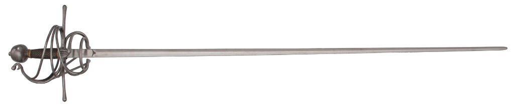
Sold2021Contemporary 17th Century Rapier by Del Tin42" blade with diamond cross-section, 1" wide at ricasso. Swept hilt guard with two pas d'ane and straight quillions. Wire-wrapped wood grip with globular pommel and peened tang. Del Tin mSee Sold Price
Sold2022TWO EUROPEAN MAPS.Mid 17th century, hand colored engravings on laid paper. William Blaeu map of "Karstia, Carniola, Histria et Windorum Marchia". Text on back. Crease. 18.5"h. 22.75"w. And Nicolaum Visscher map of "BelSee Sold Price
Sold2020TWO EUROPEAN MAPS BY WILLIAM BLAEU.Amsterdam, 2nd quarter 17th century, hand colored engravings on rag paper. "Brabantia Ducatus" and "Ducatus Holsatiae". Matching late frames, 22.5"h. 27"w. overall.See Sold Price
Sold2022Antique 17th Century EtchingsAntique etching lot. These items are from the estate of a gentleman from Gaton Lamps on Melrose Ave. Gaton Lamps worked on the interior of the White House with Jackie Kennedy. Two maps from the 17th CSee Sold Price
May 22Thomaston Place Auction GalleriesEARLY 17TH C. ELIZABETHAN ENGRAVED MAP OF CORNWALL BY WILLIAM KIP AFTER WILLIAM SAXTONUS$150
8 hrs LeftJasper521700 KING LOUIS XIV ILLUSTRATED HISTORY 95 ENGRAVINGS antique LARGE FOLIO 17th CUS$500
8 hrs LeftJasper521686 Theologiae Moralis by SPORER antique BLINDSTAMPED PIGSKIN 17 CENTURY Vol IVUS$260


![John SPEED: Two Antique Maps of Ireland: Two framed antique maps of Ireland by John Speed, a well known English cartographers circa 17th century. [Maps: 15" H x 20" W; Frames: 24" H x 28 1/2" W].](https://p1.liveauctioneers.com/1221/264089/138965458_1_x.jpg?height=310&quality=70&version=1667576821)
![Set of 2 World Globe Bookends 1960s, Italy, Repro of 17th Cent. Map: Vintage set of two [2] spinning world globe wood bookends, reproduction of the 17th Century map, unmarked, made in Italy, 1960s. The varnished wooden bookends are c.7.1/2" [20cm] high; c.6.1/2" long X](https://p1.liveauctioneers.com/6304/306619/163821540_1_x.jpg?height=310&quality=70&version=1699706364)