Sold20201598 c. de Bry Map of Madagascar -- Insula Madagascar,Title/Content of Map: 1598 c. de Bry Map of Madagascar -- Insula Madagascar, Alias S. Laurentii… / Insula de S. Laurety Cartographer: T de Bry Year/Place: 1598 c., Frankfurt Size: 5.5 X 7.6 in. ThisSee Sold Price
Sold2022Abraham Ortelius and Theodore de Bry, Two Vintage MapsABRAHAM ORTELIUS and THEODORE DE BRY (Belgian, 1527-1598), (German, 1528 - 1598), Maris Pacifici quod vulgo Mar del Zud, 1601, and Hispaniae Novae Sive Magnae, Recens et Vera Descriptio, 1595, two vinSee Sold Price
Sold2023Album of Early Maps and Ephemera Related to CubaA collectors album of maps and prints related to Cuba. There are total of 70 pieces, from the 16th to the 20th centuries. Highlights include works by Theodor de Bry, a 1561 map of Cuba by Ruscelli, aSee Sold Price
Sold2017THEODORE DE BRY (1528-1598) VIRGINIA NATIVE AMERICANTHEODORE DE BRY (1528-1598) VIRGINIA NATIVE AMERICAN ENGRAVINGS, LOT OF TWO most likely from De Bry's "Great Voyages", after John White paintings, each depicting De Bry's interpretation of Native AmerSee Sold Price
Sold2024Matthaus Merian 1627 Antique Hand Colored Map "Virginia" from Theodore de Bry's "Grand Voyages" #2Antique 1627 hand-colored map of Virginia by Matthaus Merian after John Smith's 1612 map, from Theodore de Bry's "Grand Voyages". Good condition overall, with age-appropriate wear, repairs (see photosSee Sold Price
Sold2024Matthaus Merian 1627 Antique Map Engraving "Virginia" from Theodore de Bry's "Grand Voyages" #1Antique 1627 map of Virginia by Matthaus Merian after John Smith's 1612 map, from Theodore de Bry's "Grand Voyages". Please see "The Philidelphia Print Shop" sheet shown in final photo. Good conditionSee Sold Price
Sold2019Strait of Magellan Map[Strait of Magellan Map] , "Fretum Magellannicum", by Theodore De Bry, Frankfurt, 1601, copper engraved, depicting ships, natives, a penguin and a snail, 6 1/2 in. x 11 3/4 in., framed IMPORTANT: AllSee Sold Price
Sold2015De Bry (Theodore) - Descriptio Hydrographicathe 2-sheet map of Africa and Asia, from the east coast of Brazil to Japan, charting the first Dutch voyage to the East Indies by Houtman, large titlecartouche upper centre of right sheet, ships, compSee Sold Price
Sold2017de Bry: Antique French Florida Colony View, 1590Map: The French Commander Erects a Column with the Arms of the King of France Cartographer: Theodor de Bry Place & Date: Frankfurt / 1590 Size: 9" x 13 1/4" (overall sheet) Condition: b&w as publishedSee Sold Price
Sold2018de Bry: Collecting Gold in Appalachia, 1590Title/Content of Map: Mode of Collecting Gold in Streams Running From the Apalatcy Mountains Cartographer: Theodor de Bry Place & Date: Frankfurt / 1590 Size: 9" x 13 1/4" (overall sheet) Condition: bSee Sold Price
Sold2024De Bry Native American Market EngravingEngraving with text depicting a bustling Native American market. From Theodor de Bry (Netherlandish, 1528-1598), Thomas Hariot (British, ca. 1560-1621), and John White's (British, act. 1577-93) "See Sold Price
Sold2018De Bry: Chorrera, Cuba, Sacked by the French, 1594Title/Content of Map: Chiorera (Chorrera), in Cuba, is occupied, sacked and burnt by the French Cartographer: Theodor de Bry Place & Date: Frankfurt / 1594 Size: 9" x 12 1/8" (overall sheet) ConditionSee Sold Price
Sold2017de Bry: Antique View of French Florida Colony, 1590Map: The French Left in Fort Charles Suffer from Scarcity of Provisions Cartographer: Theodor de Bry Place & Date: Frankfurt / 1590 Size: 9" x 13 1/4" (overall sheet) Condition: b&w as published; margSee Sold Price
Sold2021ENGRAVING, Florida, Natives, BryFlorida, Natives. Theodore de Bry, [Mourning the Death of a Chief] Was sie fur Ceremonien in Begrabniss Irer Konige und Priester Haben, from Grands Voyages, Part II, 1591 (published). Black & White. TSee Sold Price
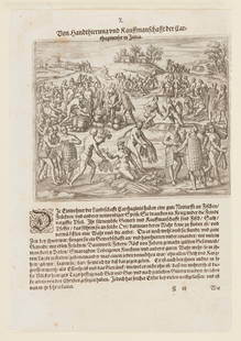
2021ENGRAVING, Acapulco, Mexico, BryAcapulco, Mexico. Theodore de Bry, [Spilbergen Lands at Acapulco] Aquapolque, from Grands Voyages, Part XI, 1630 (circa). Black & White. This engraving first appeared in Part XI of de Bry's Grands VoySee Sold Price
Sold2019KELLER & GUERIN FRENCH MAP PLATESSet of (14) blue & white French map plates "Cotes de France" by Colette Gueden for Keller & Guerin. Two plates (Avignon and Bordeaux) have hairline cracks. Two of each plates except plates with AvignoSee Sold Price
Sold2018de Bry/Benzoni: Columbus in Hispaniola, 1594Map: Columbus in India primo appellens, magnis excipitur muneribus ab Incolis Cartographer: de Bry/Benzoni Place & Date: Frankfurt / 1594 Size: 8" x 6 1/2" (image); 9" x 13 3/4" (page) Condition: b&w;See Sold Price
Sold2022MAP, Chile, Herrera y TordesillasChile. Antonio de Herrera y Tordesillas, Descripcion de la Provincia de Chile, from Description des Indes Occidentales, 1622 (circa). Black & White. Antonio de Herrera y Tordesillas was the official hSee Sold Price
Sold2018(2) antique maps of Europe by Nicolas De Fer(2) antique maps of Europe by Nicolas De Fer, "Les Suisses, Leurs Sujets et Leurs Alliez", black and white map, 1715 and "Le Golfe De Venise", hand-colored map, 1716, by Nicolas De Fer and P. StarckmaSee Sold Price
Sold2020Carte de la Caroline et Géorgie'. North/South CarolinaTITLE/CONTENT OF MAP: 'Carte de la Caroline et Géorgie [Map of the Carolinas and Georgia]' The top image on the right hand side shows the entire map. To view a close up of the map showing the level oSee Sold Price
Sold2017Bellin: Antique Map of the Carolinas and Georgia, 1757Map: Carte de la Caroline et Georgie Cartographer: Bellin Place & Date: Paris / 1757/1760 Size: 11 1/8" x 7 3/8" Condition: b&w; overall age toning; some spotting and staining; a tiny repaired puncturSee Sold Price
Sold2017Isle de Terre Neuve Map of Newfoundland & LabradorIsle de Terre Neuve - (Isle de Terre Nevve; Isle de Terre Newe ) Map of Newfoundland and Labrador, Alain Manesson Mallet, Mallet's Description de l'Univers, 1683,1st Edition, 1683. Black and White oriSee Sold Price
Sold2023Two Framed Maps of the Carolinascomprising: Mentelle & Pierre-Gilles Chanlaire, engraved by Tardieu and Valet, Carte De La Caroline Meridionale et Septentrionale et de La Virginie, Paris, 1795, engraving on laid paper with hand coloSee Sold Price
Sold2017Tardieu: Antique Map of Florida & Georgia, 1798Map: Carte de la Floride et de la Georgie Cartographer: Chanlaire & Mentelle / Tardieu Place & Date: Paris / 1798 Size: 16 3/4" x 13" The dramatic Florida map, with Georgia and parts of the CarolinasSee Sold Price
5 days LeftLeland LittleRobert de Vaugondy's 18th-Century French Map of North America's Eastern SeaboardUS$50
13 hrs LeftTrillium Antique Prints & Rare BooksDe Bry - Florida: French landing near St. AugustineUS$75
13 hrs LeftTrillium Antique Prints & Rare BooksDe Bry - Florida - Leaving. the May River, the French discover two other rivers (Sea Monster)US$75
13 hrs LeftTrillium Antique Prints & Rare BooksDe Bry - Florida - Six other river discovered by the FrenchUS$75
13 hrs LeftTrillium Antique Prints & Rare BooksDe Bry - Florida - Mode of drying fish, wild animals and other provisionsUS$75(1 bid)
13 hrs LeftTrillium Antique Prints & Rare BooksDe Bry - Florida - Bringing the wild animals, fish and other storesUS$75
13 hrs LeftTrillium Antique Prints & Rare BooksDe Bry - Florida - Industry of the Floridians in depositing their crops in the common granaryUS$75
Sep 28Trillium Antique Prints & Rare BooksDe Bry - Florida - Manner in which their hermaphrodites are employed (Stretchers)US$75
Sep 28Trillium Antique Prints & Rare BooksDe Bry - Florida - Ceremonies of women mourning for their deceased husbandsUS$75
Sep 28Trillium Antique Prints & Rare BooksDe Bry - Florida - The chief applied to by woman whose husbands have died in war or diseaseUS$75
Sep 28Trillium Antique Prints & Rare BooksDe Bry - Florida - The trophies and ceremonies that they have after returning from war victoriouslyUS$75
Sep 29Grace Auction & Estate Gallery LLCPair Hand Colored Engravings Theodor De Bry Grand Voyages 20thCUS$10
7 hrs LeftMaison Jules VeilinghuisJames ENSOR (1860-1949), colour lithograph Miamia from the folder La gamme d'amour 1929, signed in€400
Sep 29Grace Auction & Estate Gallery LLCPlan de Paris Map 1927 by Ilonka Karasz, Washington Square BookshopUS$20
13 hrs LeftTrillium Antique Prints & Rare BooksDe L'Isle - Map of Southeast North America with the Great Lakes, New England, Virginia, Florida,US$75
Sep 28Trillium Antique Prints & Rare BooksDe L'Isle - Map of Louisiana and the Course of the Mississippi (Eastern America) (First AppearanceUS$75


![Strait of Magellan Map: [Strait of Magellan Map] , "Fretum Magellannicum", by Theodore De Bry, Frankfurt, 1601, copper engraved, depicting ships, natives, a penguin and a snail, 6 1/2 in. x 11 3/4 in., framed IMPORTANT: All](https://p1.liveauctioneers.com/268/150890/76180328_1_x.jpg?height=310&quality=70&version=1569336980)


![ENGRAVING, Florida, Natives, Bry: Florida, Natives. Theodore de Bry, [Mourning the Death of a Chief] Was sie fur Ceremonien in Begrabniss Irer Konige und Priester Haben, from Grands Voyages, Part II, 1591 (published). Black & White. T](https://p1.liveauctioneers.com/6576/219830/112943107_1_x.jpg?height=310&quality=70&version=1632515120)
![ENGRAVING, Acapulco, Mexico, Bry: Acapulco, Mexico. Theodore de Bry, [Spilbergen Lands at Acapulco] Aquapolque, from Grands Voyages, Part XI, 1630 (circa). Black & White. This engraving first appeared in Part XI of de Bry's Grands Voy](https://p1.liveauctioneers.com/6576/219830/112943120_1_x.jpg?height=310&quality=70&version=1632515120)


![Carte de la Caroline et Géorgie'. North/South Carolina: TITLE/CONTENT OF MAP: 'Carte de la Caroline et Géorgie [Map of the Carolinas and Georgia]' The top image on the right hand side shows the entire map. To view a close up of the map showing the level o](https://p1.liveauctioneers.com/5584/182355/91727171_1_x.jpg?height=310&quality=70&version=1603285541)


