Sold2023AFTER NICOLAS SANSON (FRENCH, 1600-1667) MAP OF CALIFORNIA AS AN ISLANDAFTER NICOLAS SANSON (FRENCH, 1600-1667) MAP OF CALIFORNIA AS AN ISLAND, hand-colored engraving on laid paper, titled "AUDIENCE DE / GUADALAJARA / NOUVEAU MEXIQUE / CALIFORNIE, &c. / Par N. SSee Sold Price
Sold2018AFTER NICOLAS SANSON (FRENCH, 1600-1667) MAP OF NORTHAFTER NICOLAS SANSON (FRENCH, 1600-1667) MAP OF NORTH AMERICA, hand-colored, on laid paper, title in cartouche to upper left corner lettered "NORTH AMERICA / Divided into it's Principall Parts / whereSee Sold Price
Sold2023AFTER NICOLAS SANSON (FRENCH, 1600-1667) MAP OF FLORIDAAFTER NICOLAS SANSON (FRENCH, 1600-1667) MAP OF FLORIDA, hand-colored engraving on laid paper, titled "FLORIDA / zoo als het van de / SPAANSCHEN en FRANSCHEN / wordt bezeten. / door N. Sanson. /See Sold Price
Sold2022Alexis Hubert Jaillot and Nicolas Sanson - Map of the Grand Duchy of Moscow, Etching, 1708.Alexis Hubert Jaillot (French, 1632-1712) and Nicolas Sanson (French, 1600-1667) - Map of the White Russia or the Grand Duchy of Moscow, Etching, 1708. Title: Les Estats du Czaar de Russie Blanche ouSee Sold Price
Sold2023AFTER NICOLAS SANSON (FRENCH, 1600-1667) MAP OF CANADAAFTER NICOLAS SANSON (FRENCH, 1600-1667) MAP OF CANADA, hand-colored engraving on laid paper, titled "CANADA / of / NIEW VRANKRYK / Getrokken uit verfscheide Franfche, / Engelfche, en HollanSee Sold Price
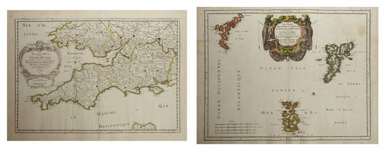
Sold2023AFTER NICOLAS SANSON (FRENCH, 1600-1667) MAP OF GREAT BRITAINAFTER NICOLAS SANSON (FRENCH, 1600-1667) MAP OF GREAT BRITAIN, hand-colored engraving on laid paper, engraving by Robert De Vaugondy. Unframed. Circa 1750. 21 3/4" x 31". Provenance: BSee Sold Price
Sold2017Nicolas Sanson, 17th c. map of Imperial RomeNicolas Sanson, 17th c. map of Imperial Rome, Nicolas Sanson (French, 1600-1667), "Imperii Romani geographica descriptio ad Herodiani historiam", c. 1650, Roman territory throughout Europe and Asia asSee Sold Price
Sold2018Small 1735 French map with California as an Island andTitle: Amerique Septentrionale par N. Sanson d'Abbeville Geographe du Roy Map maker: Nicolas Sanson, Introduction a l'histoire de l'Asie, de l'Afrique et de l'Amerique... par Mr. Bruzen la MartiniereSee Sold Price
Sold2018AN 1659 FRENCH MAP OF DENMARK BY NICOLAS SANSONA hand-colored map of Northern Denmark by Nicolas Sanson (1600-1667), signed Sanson and dated with a cartouche on the lower left. Sheet measures 16.25 x 21 inches. Frame measures 20.5 x 26.5 inches. WSee Sold Price
Sold2022French Le Maine hand colored map engraving, central France, by Nicolas Sanson (1600-1667) 15"H xFrench Le Maine hand colored map engraving, central France, by Nicolas Sanson (1600-1667) 15"H x 19"W (image), 23"H x 30 3/4"W (frame)See Sold Price
Sold2019Three Maps by Nicolas Sanson (1600-1667, Paris), Two-Three Maps by Nicolas Sanson (1600-1667, Paris), Two- "Carte Generalle d'Espagne .. Royaumes," 1641; together with "Gouvernement General d'Orteans Maine, le Perche, la Beauce..Gastinois," 1650, hand cSee Sold Price
Sold2019Two Maps by Nicolas Sanson (1600-1667, Paris), "Isle deTwo Maps by Nicolas Sanson (1600-1667, Paris), "Isle de France, Champagne, Lorraine," 1679; together with "Le Royaume de France, Toutes ses Provinces, et ses Acquisitions, L'Espagne le Luxembourg," 16See Sold Price
Sold2019Three Maps by Nicolas Sanson (1600-1667, Paris),Three Maps by Nicolas Sanson (1600-1667, Paris), "Lespagne en Plusieurs Peuples suiant Peolomee," 1641; together with two- "Galliae Antiquae Descriptio Geographica," 1629 Geographica- H. - 17 in., W.See Sold Price
Sold2019Two Maps by Nicolas Sanson (1600-1667, Paris), " LaTwo Maps by Nicolas Sanson (1600-1667, Paris), " La France L'Ancienne Gaule Primatiats… ar Evesches et Evesches," 1679; together with "Le Royaume de France et es Acqusitions Pays Bas L'AllemagneSee Sold Price
Sold2019Group of Three Maps by Nicolas Sanson (1600-1667,Group of Three Maps by Nicolas Sanson (1600-1667, Paris), "La Gaule en dixsept provinces Romain," 1641; together with "Gouvernment General du Lyonnois, Forez, Beavoilais," 1679; and "Gouvernment De FrSee Sold Price
Sold2019Two Maps by Nicolas Sanson (1600-1667, Paris),Two Maps by Nicolas Sanson (1600-1667, Paris), "Provinces d'West Royame d'Westsex," 1679; together with"Les Isles Orcadney, ou Orkney Farre," 1665, Orcadney- H. - 16 in., W. - 23 in., d'Westsex- H. -See Sold Price
Sold2019Two Maps by Nicolas Sanson (1600-1667, Paris), "LeCoursTwo Maps by Nicolas Sanson (1600-1667, Paris), "LeCours de la Riviere du Rhein. Tous LeDauphin les Estats et Souverainetes," 1692; together with "Gallia Vetus ex C.lulii C aefaris comentarii descripaeSee Sold Price
Sold2019Two Maps by Nicolas Sanson (1600-1667, Paris)," AncientTwo Maps by Nicolas Sanson (1600-1667, Paris)," Ancient Royaume de Northumbland and Provinces de Nort," 1679; together with " L'Escosse de la Tay… Provinces… Stralloch," 1665, Stralloch- HSee Sold Price
Sold2019Two Maps by Nicolas Sanson (1600-1667, Paris),Two Maps by Nicolas Sanson (1600-1667, Paris), "L'Estats de'Englise et de Toscane," 1648, together with "Nicens Ory de Mercie," 1654 H. - 17 in., W. - 23 in. (2 Pcs.)See Sold Price
Sold2019Two Maps by Nicolas Sanson (1600-1667, Paris),Two Maps by Nicolas Sanson (1600-1667, Paris), "Principaute de Galles, Nort Walles," 1679; together with "Hispaniae Antiqua Tabulae," 1641, hand colored, Tabulae- H. - 16 in., W. - 23 in., Galles- H.See Sold Price
Sold2019Two Maps by Nicolas Sanson (1600-1667, Paris), "LaTwo Maps by Nicolas Sanson (1600-1667, Paris), "La Judee ou Palestine Herodes," together with "Gouvernement General de L'lsle de France et Pays Circomvoisins," 1679, France- H. - 15 in., W. - 20 in.,See Sold Price
Sold2019Two Maps by Nicolas Sanson (1600-1667, Paris), "CarteTwo Maps by Nicolas Sanson (1600-1667, Paris), "Carte General du Royaume de France Auceq tousles Pays Circomuoisins," 1658; together with "Anciens Royaumes de Kent, D'Essexet de Sussex de Picardie etSee Sold Price
Sold2019Two Maps by Nicolas Sanson (1600-1667, Paris),Two Maps by Nicolas Sanson (1600-1667, Paris), "Picardie et les Pays Bas Catholiques," 1667; together with "Carte des Rivieres de la France," 1641, hand colored, France- H. - 17 in., W. - 23 in., CatoSee Sold Price
Sold2019Two Maps by Nicolas Sanson (1600-1667, Paris),Two Maps by Nicolas Sanson (1600-1667, Paris), "L'Estats de'Englise et de Toscane," 1648, H. - 17 in., W. - 23 in. (2 Pcs.)See Sold Price
2 days LeftPotter & Potter AuctionsLISTER, James Wren (1897 – 1952). Avalon Town / Santa Catal...US$100(1 bid)
3 hrs LeftRapid Estate Liquidators and Auction GalleryRéunion Island Stamps 1917 Four Rare OverprintUS$60
2 days LeftPotter & Potter AuctionsPictorial Map of Hollywood and Vicinity / Hollywood Film Ca...US$125(1 bid)
5 days LeftThe Heritage Gallery at Sayville Antiques, IncEtienne Ret O/B Mid Century Painting Titled RoosterUS$50(1 bid)
4 days LeftBlackstone Valley Auctions & Estates LLCAntique Treasure Island Reverse Glass Banjo Clock.US$150
Jun 06Austin Auction GalleryLARGE FRENCH PAUL NICOLAS D'ARGENTAL ECOLE DE NANCY CAMEO GLASS VASEUS$325(2 bids)
2 days LeftEldred'sAFTER CLAUDE LORRAIN (France/Italy, circa 1600-1682), "Mercury, Argos and Io", 18th Century.,US$150
290 Lots AwayHermann Historica GmbHA pair of fine Italian or French Renaissance bronzes, circa 1600See Sold Price
Jun 02Broward Auction GalleryErnest Peixotto (CA,NY,French,1869-1940) oil painting antiqueUS$20(2 bids)
May 24Eldred'sATTRIBUTED TO PAUL DOUGHERTY (California/New York/France, 1877-1947), House nestled in the trees.,US$150