Sold2024James Cook - Map / Chart Of The Island TahitiEngraved nautical map from the 1774 first French edition of the first map of New Zealand, illustrating Lieutenant James Cook's 1769 exploration of the passage between New Zealand's North and South islSee Sold Price
Sold2021RAYMOND MASSEY "RESOLUTION & DISCOVERY" LITHOGRAPH- RAYMOND A. MASSEY (AMERICAN: 20TH CENTURY)- LITHOGRAPH ON PAPER DEPICTING CAPTAIN JAMES COOK'S THIRD VOYAGE TO THE PACIFIC, AFTER MAKING LANDFALL AT KAWAI POINT, REACHING DOWNWARDS THE SOUTH COAST OSee Sold Price
Sold2016James Cook, Carte Des Decouvertes Mer PacifiqueAn engraved map / chart of the Pacific Islands, Carte Des Decouvertes faites dans la Mer Pacifique, Commande par le Capitaine Cook, en 1774. Authored by Captain James Cook in 1774, with Nouvelle CaledSee Sold Price
Sold2023James Cook Antiquated MapAntiquated framed and glazed map / 'agenera chart' depicting the voyages and discoveries of Captain James Cook height 28 in. x width 42 in. x depth 1.5 in. We happily provide seamless shippiSee Sold Price
Sold2020James Cook, Surveyor of Newfoundland 1965 1/365Heading: (Cook, James) Author: Skelton, R.A., intro. Title: James Cook, Surveyor of Newfoundland: Being a Collection of Charts of the Coasts of Newfoundland and Labradore, &c. Drawn from Original SurvSee Sold Price
Sold2022c. 1781 Captain Cook Voyages Map, London by Alexander HoggHistoric Maps "A Plan of Success Bay in Strait Le Maire / A Chart of the S.E. part of Terra del Fuego... by Captn. Cook 1769" c. 1781, A "Dual" Map from Captain Cook's Voyages, titled: "A Plan of SuccSee Sold Price
Sold2022c. 1781 Captain Cook Voyages Map, London by Alexander HoggHistoric Maps "A Plan of Success Bay in Strait Le Maire / A Chart of the S.E. part of Terra del Fuego... by Captn. Cook 1769" c. 1781, Dual Map from Captain Cook's Voyages, titled: "A Plan of SuccessSee Sold Price
Sold2019JAMES WEDDELL Voyage Toward South Pole 1822 Cape BlancoRare old print from the published charts of Captain James Weddell "Voyage Towards The South Pole". Cape Blanco on the coast of Patagonia. 1822. 18 1/2 x 4 1/2 in. (sight). 26 x 13 in. (framed).See Sold Price
2024A New & Accurate Chart of the Discoveries of Captn Cook… CONDER 1794 old mapTITLE OF MAP (NOT PRINTED ON THE PAGE):'A New & Accurate Chart of the Discoveries of Captn Cook & other Later Circumnavigators : Exhibiting the whole coast of New South Wales, shewing the situations oSee Sold Price
Sold2023Book: Captain James Cook Charts & Views, R.A. Skelton Edition, Hakluy Society, Cambridge 1969.Book: Captain James Cook Charts & Views, R.A. Skelton Edition, Hakluy Society, Cambridge 1969.See Sold Price
Sold2019Cpt James Cook - Voyages Around the WorldPublished 1820 AD. Cook, Captain James, Cook's Voyages Embellished with Engravings: Voyages Around the World Performed by Captain James Cook, published 65 parts, J Robins & Co London, 1820; new editioSee Sold Price
Sold20241783 Captain James Cook Third Pacific Voyage Illustrated MAP Australia Rickman1783 Captain James Cook Third Pacific Voyage Illustrated MAP Australia Rickman “Remember, the greater the opportunity, the fewer are those who see it.” – James Cook James Cook was an 18th-ceSee Sold Price
Sold2021Antique Map of Captain James Cook's Voyages to theAntique map of Captain James Cook's voyages to the Pacific region. Captain Cook made numerous discoveries in the Pacific region during the late 1700's . Artists and mapmakers aboard the ship, includinSee Sold Price
Sold2018Vancouver: Antique Chart of Northwest Coast of AmericaTitle/Content of Map: A Chart Shewing Part of the Coast of N.W. America, with the Tracks of His Majesty's Sloop Discovery and Armed Tender Chatham . . . [Columbia River to Northern California] Date PrSee Sold Price
Sold20191783 Captain James Cook Third Pacific Voyage Illustrate1783 Captain James Cook Third Pacific Voyage Illustrated MAP Australia Rickman “Remember, the greater the opportunity, the fewer are those who see it.” – James Cook James Cook was an 18th-centurSee Sold Price
Sold2018World chart with discoveries of James Cook 1787Heading: Author: Faden, William Title: A New General Chart of the World, Exhibiting the Whole of the Discoveries made by the late Captain James Cook, F.R.S. with the Tracks of the Ships under his ComSee Sold Price
Sold2023World: Captain Cook, Large Folio - A General Chart Exhibiting the Discoveries made by Captain JamesThis fascinating folio engraving is from Captain James Cook & James King's A Voyage to the Pacific Ocean, for making Discoveries in the Northern Hemisphere. To determine the Position and Extent of theSee Sold Price
Sold2024James Cook - Map of Tahiti, the Society Islands, and the VicinityEngraved nautical map from the 1774 first French edition of the first map of New Zealand, illustrating Lieutenant James Cook's 1769 exploration of the passage between New Zealand's North and South islSee Sold Price
Sold2023Wright, Thomas 1852 Portrait Print. Captain James Cook, AustraliaSteel Engraved Map Published 1852-56, London for "The Universal Pronouncing Dictionary" by Thomas Wright. Paper Size: 10.5 x 7 inch (27 x 18cm) Margin toning and staining present. Image fineSee Sold Price
Sold2022Antique Map Print of Oceania - Map of Madeira & The Azores - 1870 - James CookOriginal Antique Decorative Map of Madeira & The Azores, Fullarton, C.1870 This fascinating folio engraving is from Captain James Cook & James King's "A Voyage to the Pacific Ocean, for making DiscoveSee Sold Price
Sold20241842 VOYAGES OF CAPTAIN JAMES COOK 2 VOLUMES antique ILLUSTRATEDThe Voyages of Captain James Cook London: William Smith, 1842 2 volumes Size 7 by 9 3/4" Additional engraved title in volume I, engraved frontispieces, double-page maps, in-text vignettes, etc. MinorSee Sold Price
Sold2017Cooks Voyages with maps by TallisHeading: Author: Cook, James Title: The Voyages of Captain James Cook Round the World Place Published: London & New York Publisher:James Tallis & Company Date Published: c.1860 DescripSee Sold Price
Sold2021VTG MASSEY RESOLUTION & DISCOVERY SIGNED PRINT 46"VINTAGE MASSEY HMS RESOLUTION & HMS DISCOVERY SHIP PRINT | SHIPS BOATS MARITIME COASTAL NAUTICAL DECOR -OFF THE COAST OF AUSTRALIA THIRD VOYAGE OF CAPTAIN JAMES COOK FROM THE BOOK OF SHIPS PRINTED C 1See Sold Price
Sold2018Antique Chart of the Island of Tahiti, 1775Title/Content of Map: Chart of the Island of Otaheite Date Printed: 1775 ca. Cartographer: Capt. James Cook R.N. Size (inches): 12.3x16.1 Large scale map of the Island of Tahiti, with detailed typograSee Sold Price
3 days LeftJasper521796 VOYAGES of CAPTAIN COOK 3 vols 1st US EDITION ILLUSTRATED antique ENGLISHUS$1,000
5 days LeftZikorn Arts & History ObjectsWest Indies, Western Cuba 1879 British Admiralty Nautical MapUS$100
20 mins LeftTrillium Antique Prints & Rare BooksWebber & Cook, Rare - A Sailing Canoe of OtahaiteUS$500
20 mins LeftTrillium Antique Prints & Rare BooksWebber & Cook, Rare - View of the Harbour of Taloo, in the Islands of EimeoUS$500
20 mins LeftTrillium Antique Prints & Rare BooksWebber & Cook, Rare - A Toopapaoo of a Chief, with a Priest Making His Offering to the Morai, inUS$500
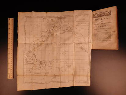
Jun 07Freeman's | HindmanCOOK, James, Captain. -- [SECOND VOYAGE]. A Voyage towards the South Pole, and Round the World...US$1,500
Jun 02Schilb Antiquarian Rare Books1880 Captain James Cook Voyages Hawaii Pacific Australia Kippis South Sea NavyUS$1(1 bid)
4 days LeftJasper52A Chart of the Sea Coast from England to the Streights. MOUNT & PAGE 1758 mapUS$500
Featured4 days LeftJasper52Chart of the Sea Coasts of England, Flanders & Holland. MOUNT & PAGE 1758 mapUS$420
5 days LeftZikorn Arts & History ObjectsCentral America West Coast 1855 British Admiralty Nautical ChartUS$100(1 bid)
5 days LeftZikorn Arts & History ObjectsWest Indies, Eastern Cuba 1881 British Admiralty Nautical MapUS$100
20 mins LeftTrillium Antique Prints & Rare BooksPrevost - Map of the South Pacific Ocean with New Holland (Australia), New Zealand, and part of theUS$50(1 bid)
4 days LeftUniversity ArchivesScarce Early Printing: "An Account of the European Settlement in America in 6 Parts..."US$100
20 mins LeftTrillium Antique Prints & Rare BooksAudubon, Imperial Folio - White American Wolf. 72US$375(1 bid)
1 day LeftArarity AuctionsAntique 19thC American Needlepoint Sampler Family of Captain James ShepardUS$25(1 bid)


![Vancouver: Antique Chart of Northwest Coast of America: Title/Content of Map: A Chart Shewing Part of the Coast of N.W. America, with the Tracks of His Majesty's Sloop Discovery and Armed Tender Chatham . . . [Columbia River to Northern California] Date Pr](https://p1.liveauctioneers.com/5584/114563/58815189_1_x.jpg?height=310&quality=70&version=1514941693)


![COOK, James, Captain. -- [SECOND VOYAGE]. A Voyage towards the South Pole, and Round the World... (1 of 2)](https://p1.liveauctioneers.com/197/329395/177650491_1_x.jpg?height=282&quality=70&version=1715364962)


