Sold2019Colton's Delaware/Maryland Map [Southern States]Colton's Delaware and Maryland Map; Delaware on the right, Maryland on the left. J. H. Colton Cartographer. Published by J. H. Colton, New York. Insert of 'District of Columbia' lower left. Stamped 'ESee Sold Price
Sold20241833 Map of Pennsylvania, New Jersey, MaryLand, Delaware, Columbia and Part of VirginiaMap published by Baldwin and Cadock in 1833. Map measures approx 13 1/4" x 18" Overall good condition.See Sold Price
Sold20211833 SDUK Map of US Mid-Atlantic -- North America SheetTitle: 1833 SDUK Map of US Mid-Atlantic -- North America Sheet VII - Pennsylvania, New Jersey, Maryland, Delaware, Columbia and part of Virginia Cartographer: SDUK Year / Place: 1833, London Map DimenSee Sold Price
Sold2017USA. Pennsylvania New Jersey Maryland Delaware DCTitle/Content of Map: 'NORTH AMERICA, SHEET VII., Pennsylvania, New Jersey, Maryland, Delaware, Columbia, Virginia' Date Printed: 1846 Image Size: Approx 39.5 x 34.5cm, 15.5 x 13.75 inches (Large) TypSee Sold Price
Sold20164 maps: Colonial US, Maryland, DC, Railroads[Railroads/MD/DC] 4 Maps. ++ J.G. Langdon. MAP OF THE DISTRICT OF COLUMBIA 1901… FOR THE PREPARATION OF A PLAN FOR THE IMPROVEMENT OF THE PARK SYSTEM OF THE DISTRICT OF COLUMBIA. NO. D-99. Balt: A.See Sold Price
Sold20231795 Map, Maryland & Delaware [18th c. Cartography]Engraved map of Maryland and Delaware printed in 1799, based on a 1795 edition produced by Samuel Lewis. Drawn by A. Anderson, engraved by J. Scoles. Includes an inset map of the Continuation of the PSee Sold Price
Sold2020North America Sheet VII Pennsylvania, New Jersey,Publication Date: 1852 Title: North America Sheet VII Pennsylvania, New Jersey, Maryland, Delaware, Columbia and Part of Virginia. Rhode-Island, And New-Jersey. Cartographer: Society for the DiffusionSee Sold Price
Sold2016Map of Maryland, Delaware and Washington, DC, 1796Original engraving from Morse’s Universal Geography published by Thomas & Andrews, Boston, 1796. Dimensions: 12 3/4” x 15” No Reserve This item ships from Ocean View, DE.See Sold Price
Sold2022Beautiful 1850 engraved map of Maryland & Delaware“A New Map of Maryland and Delaware with their Canals, Roads & Distances” published by Thomas, Cowperthwait, and from an 1854 edition of Mitchell’s New Universal Atlas published by CSee Sold Price
Sold2022Vintage RR map of Maryland & Delaware, 1850Excellent 1850 map of Maryland and Delaware with a chart of Chesapeake Bay Steamboat Routes. Published a decade before the Civil War and during an explosion in the country's railroad routes, the map aSee Sold Price
Sold20211855 Colton Map of Maryland, Delaware and Washington DCTitle: 1855 Colton Map of Maryland, Delaware and Washington DC -- Delaware and Maryland Cartographer: J Colton Year / Place: 1855, New York Map Dimension (in.): 11.8 X 15.8 in. This is a very nice mapSee Sold Price
Sold2018Johnson: Antique Map of Maryland & Delaware, 1863Title/Content of Map: 1863 Johnson Map of Maryland and Delaware -- Johnson's Delaware and Maryland Date Printed: 1863, New York Cartographer: A Johnson Size: 12.5 x 15.8 in. A very nice map of these tSee Sold Price
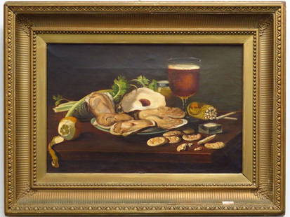
Sold2016ANDREW JOHN HENRY WAY (AMERICAN MARYLAND/DISTRICT OFANDREW JOHN HENRY WAY (AMERICAN MARYLAND/DISTRICT OF COLUMBIA 1826-1888), OIL ON CANVAS, STILL LIFE WITH OYSTERS AND BEER, SIGNED 1871. 12 X 18"; FRAMED 20 X 25" PROVENANCE: ESTATE OF ALBERT WEIL (LABSee Sold Price
Sold2021Attr. Andrew John Henry Way (1826 - 1888)Attr. Andrew John Henry Way (Maryland, District Of Columbia, 1826 - 1888) Painting of Grapes. 19th Century Oil on Board. Appears to be unsigned, has not been examined out of frame. Sight Size: 18 x 14See Sold Price
Sold2015Maryland, Delaware & PennsylvaniaA rare map of Maryland, Delaware & Pennsylvania that pre-dates Delaware as a state. Delaware is shown as part of New Jersey. Map also features Lord Fairfax's Boundary, Fort and Ohio Company, Great WagSee Sold Price
Sold2016Maryland, Delaware & PennsylvaniaA rare map of Maryland, Delaware & Pennsylvania that pre-dates Delaware as a state. Delaware is shown as part of New Jersey. Map also features Lord Fairfax's Boundary, Fort and Ohio Company, Great WagSee Sold Price
Sold2017David Driskell, Woodcut/Silkscreen, Fruit BowlDavid Driskell (Maryland/District of Columbia, b. 1931) woodcut and silkscreen print on board depicting an abstract bowl of fruit. Signed and dated "Driskell 68", lower center of fruit bowl. Float mouSee Sold Price
Sold2021Mitchell: Maryland & Delaware / New Jersey, 1870Title/Content of Map: Mitchell: Maryland & Delaware / New Jersey, 1870 Date Printed: 1870, Philadelphia Cartographer: S. A. Mitchell Size: 14" x 11 1/2" Two well detailed and colored county maps, oneSee Sold Price
2023MAP OF MARYLAND AND DELAWARE BY JOHN REID.Engraved map on laid paper, published by John Reid, New York. "The States of Maryland and Delaware, from the Latest Surveys, 1795" with Chesapeake Bay in the middle. Stains, minor creases, glued down.See Sold Price
Sold20231795 J. Denison & A. Doolittle Maryland/Delaware Map1795 J. Denison & A. Doolittle Maryland/Delaware Map of the States Maryland And Delaware by J. Denison. 7 1/2 x 10 in acid free matt.See Sold Price
Sold20231864 Birds Eye View of Virginia, Maryland, and District of Columbia19th century. Charles Magnus Printing New York, c. 1864. Titled Panorama of the Great War; drawn from nature/litho by John Bachmann. Overall fair condition; large splitting and cracks throughout mapSee Sold Price
Sold20211831 Hinton Map of Virginia, Maryland, Delaware andTitle: 1831 Hinton Map of Virginia, Maryland, Delaware and Washington DC -- Map of the States of Virginia, and Maryland Cartographer: J Hinton Year / Place: 1831, London Map Dimension (in.): 9.7 X 15.See Sold Price
Sold2022Scarce 1846 map of Maryland and Delaware by MitchellStrikingly lovely map of Maryland and Delaware by perhaps the premier map producer of the mid-19th century. The map is centered on Washington, D. C., and extends eastward from Maryland to New Jersey aSee Sold Price
6 days LeftJasper521880 Gray Map of Maryland, Delaware and Washington DC -- Maryland, Delaware and the District ofUS$75
Jun 16Broward Auction GalleryJoseph Conover Claghorn (DC,MD,PA,1869-1947) watercolor painting antiqueUS$10
1 day LeftHunt and Peck Estate Services, Inc.ANTONIO ZATTA (ITALIAN, 18TH CENTURY) MAP OF VIRGINIAUS$80(2 bids)
7 days LeftUniversity ArchivesWilliam McKinley Appoints Attorney of the U.S. for District of Columbia.US$240
2 days LeftBK Auctions1850s $1 Citizens Bank District of Columbia Obsolete Note PMG Choice About Unc 58EPQUS$1
1818 AuctioneersMaps. Lake District interest. Cumberland and Westmorland Antiquarian and Archaeological Society£16
7 days LeftUniversity ArchivesEphemera Collection from the Nation's Centennial Celebration, 1900US$100


![Colton's Delaware/Maryland Map [Southern States]: Colton's Delaware and Maryland Map; Delaware on the right, Maryland on the left. J. H. Colton Cartographer. Published by J. H. Colton, New York. Insert of 'District of Columbia' lower left. Stamped 'E](https://p1.liveauctioneers.com/5755/154409/77936946_1_x.jpg?height=310&quality=70&version=1573094011)


![4 maps: Colonial US, Maryland, DC, Railroads: [Railroads/MD/DC] 4 Maps. ++ J.G. Langdon. MAP OF THE DISTRICT OF COLUMBIA 1901… FOR THE PREPARATION OF A PLAN FOR THE IMPROVEMENT OF THE PARK SYSTEM OF THE DISTRICT OF COLUMBIA. NO. D-99. Balt: A.](https://p1.liveauctioneers.com/179/85723/44107986_1_x.jpg?height=310&quality=70&version=1457208384)
![1795 Map, Maryland & Delaware [18th c. Cartography]: Engraved map of Maryland and Delaware printed in 1799, based on a 1795 edition produced by Samuel Lewis. Drawn by A. Anderson, engraved by J. Scoles. Includes an inset map of the Continuation of the P](https://p1.liveauctioneers.com/7226/275519/144720286_1_x.jpg?height=310&quality=70&version=1673742614)