Sold20231795 J. Denison & A. Doolittle Maryland/Delaware Map1795 J. Denison & A. Doolittle Maryland/Delaware Map of the States Maryland And Delaware by J. Denison. 7 1/2 x 10 in acid free matt.See Sold Price
Sold2017Map of the States of Maryland & DelawareCirca 1796 Antique Map, Title: "Map of the States of Maryland and Delaware". Citation: by J. Denison. Amos Doolittle, Sculp. Approximate size: 10-5/8" x 8-3/8". Please note that this lot has a confideSee Sold Price
Sold2017Map of the States of New Hampshire & VermontCirca 1796 Antique Map Title: "Map of the States of New Hampshire and Vermont". Citation: by J. Denison. Amos Doolittle, Sculp. Approximate size: 10-3/8" x 8-3/8". Please note that this lot has a confSee Sold Price
Sold2017Map of the State of New York by J. DenisonCirca 1796 Antique Map, Title: Map of the State of New York by J. Denison. A. Doolittle (sculp.) Approximate size: 10-5/8" x 8-3/8". Please note that this lot has a confidential reserve. When you leavSee Sold Price
Sold20231795 Map, Maryland & Delaware [18th c. Cartography]Engraved map of Maryland and Delaware printed in 1799, based on a 1795 edition produced by Samuel Lewis. Drawn by A. Anderson, engraved by J. Scoles. Includes an inset map of the Continuation of the PSee Sold Price
Sold20211796 MAP OF NORTH & SOUTH CAROLINA, DENISON, FRAMEJ. Denison (American, 18th century). "Map of North and South Carolina" -1796, from "Morse's Universal Geography", engraving. Framed. Provenance: From the Lifetime Collection of Billy S. Arant, Jr., ChSee Sold Price
Sold2024"Vermont From Actual Survey," Amos Doolittle, 1795"Vermont From Actual Survey," Amos Doolittle, 1795. Engraved and hand-colored map of Vermont, the cartouche bordered with pine trees and waterfalls, inscribed "VERMONT, From actual Survey, DelineatedSee Sold Price
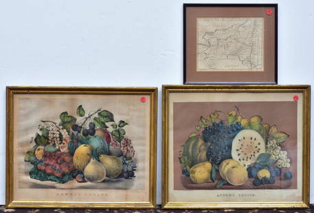
Sold2020Two Currier & Ives PrintsAutumn Fruits and Summer Fruits each 15 1/2" x 19" stone lithographs and a Map of the State of New York by J. Denison, published by Thomas & Andrews, Boston, 1796See Sold Price
Sold2022Antique Map of America - South America - Peru - Brazil - Paraguay - J. PukeAntique map of South America drawn from the latest discoveries published by J. Puke. Technique: Steel Engraving. Date: c 1795. Artist: J. Puke. Place: London, England. Size: 10” x 13” inchSee Sold Price
Sold20211855 Colton Map of Maryland, Delaware and Washington DCTitle: 1855 Colton Map of Maryland, Delaware and Washington DC -- Delaware and Maryland Cartographer: J Colton Year / Place: 1855, New York Map Dimension (in.): 11.8 X 15.8 in. This is a very nice mapSee Sold Price
Sold2016Map of Asia. J. Russell.From The Compendious Geographical Dictionary Maker: Russell, J. Origin: London, 1795. Medium: Engraving with early hand-coloring. Sheet size: 5 x 6 1/2 in. No Reserve: This lot starts at $1 and has noSee Sold Price
Sold20231795 Carey's Am Ed of Guthries Impr Geography1795 Matthew Carey "Carey's American Edition of Guthrie's Geography Improved", 1st edition of the 1st American printed atlas, 43 of 44 maps remaining, incl Doolittle's Vermont, Virginia, the CarolinasSee Sold Price
Sold20211831 Hinton Map of Virginia, Maryland, Delaware andTitle: 1831 Hinton Map of Virginia, Maryland, Delaware and Washington DC -- Map of the States of Virginia, and Maryland Cartographer: J Hinton Year / Place: 1831, London Map Dimension (in.): 9.7 X 15.See Sold Price
Sold2021Framed Map of the States Maryland & Delaware from 1790Engraving by A. Doolittle, Published by Thomas & Andrews. From "The American Universal Geography" 3D 10"H x 8 1/4"WSee Sold Price
Sold2021Colton’s map of the Southern States.Title: Coltonâ€â„¢s map of the Southern States. Publication Date: 1861 Cartographer: J. Calvin Smith Publisher: Joseph Hutchins Colton Description: Including Maryland, Delaware, Virginia, KenSee Sold Price
Sold2022MAP: "An Accurate Map of Hindostan and India", from the best Authorities, 1795, published by MatthewMAP: "An Accurate Map of Hindostan and India", from the best Authorities, 1795, published by Matthew Carey (1760- 1839), Philadelphia, J.T. Scott sculp., engraved for Carey's American Edition of GuthrSee Sold Price
Sold20191861 Delaware and Maryland, Johnson & BrowningVery clean and excellent map of Maryland and Delaware dating to 1861 by A. J. Johnson. This is the most decorative example of Johnson's Maryland - Delaware series. Along the top of the map are three eSee Sold Price
Sold2022Surrey.- Greenwood (C. & J.) Map of the County of Surrey from an actual Survey, made in the yearsNO RESERVE Surrey.- Greenwood (C. & J.) Map of the County of Surrey from an actual Survey, made in the years 1822 and 1823..., large county map, with vignette of Kew Palace, compass rose, calligraphicSee Sold Price
Sold2019Wilem J. Blaeu mapWilem J. Blaeu (Dutch 1571-1638)- Americae Nova Tabula- engraved map with hand-coloring, ca. 1633. 16 1/4 x 21 1/2''See Sold Price
Sold2022Rare map of Chinatown, San Francisco, 1929Heading: -1929 Author: Wong, J.P. Title: Map of San Francisco Chinatown / ????????: ??? / Meiguo Sanfan Shi hua qiao qu: xiang xi tu Place Published: San Francisco Publisher: Date Published:See Sold Price
Sold2022Mission & Noe Valley subdivision, 1854Heading: -1854 Author: Gardiner, James J. Title: Map of Horner's Addition City of San Francisco Surveyed for John M. Horner by J.J. Gardiner City & County Surveyor, San Francisco June 1st 1854 Place PSee Sold Price
Sold2021Rare map of Oakland with ms. transit lines 1893Heading: (California - Oakland) Author: Dingee, William J. Title: William J. Dingee's Map of Oakland, showing the properties of the Mutual Investment Union. 1893 Place Published: [Oakland?] Publisher:See Sold Price
Sold20231795 Joseph Scott Map Of DelawareScarce early 1795 Scott's Map Of Delaware from his The United States Gazetteer. Measures 7 1/2 x 6 inches in matt. Framed.See Sold Price
5 days LeftJasper52CABOOL PUNJAB & BELOOCHISTAN. Pakistan Afghanistan Kabul. RAPKIN/TALLIS 1851 mapUS$150
Jun 23Schilb Antiquarian Rare Books1977 JRR Tolkien 1st ed Silmarillion Lord of the Rings Middle Earth + MAPUS$3(2 bids)
Jun 07Freeman's | HindmanMURCHISON, Roderick Impey, Sir. The Silurian System. 1839. COMPLETE WITH VERY RARE HAND-COLOREDUS$1,500
Jun 23Treasure Quest AuctionsGreene County, NY Directory for 1896 by Fred Craigie, Catskill NY with MapUS$50
4 days LeftJasper521892 Cowles Civil War Map of Battles in Gettysburg, Virginia, W Virginia and Maryland -- Sketch ofUS$55
Featured4 days LeftJasper521764 Bellin Map of Lesser Antilles Northern Portion -- Petites Antilles ou Isles du Vent 3e. Partie.US$130
4 days LeftJasper521879 Powell Map of Utah -- Map of Utah Territory Representing the Extent of the Irrigable, TimberUS$120
4 days LeftJasper52Quarry Map Showing the Situation and Size of the More Important Slate Quarries in The "UnfadingUS$20
4 days LeftJasper521764 Bellin Map of Brazil from the Sao Paulo Area to Salvador -- Suite du Bresil Depuis la Baye deUS$30
4 days LeftJasper521764 Bellin Map of Northern Portion of Martinique -- Partie Septentrionale de la MartiniqueUS$45
4 days LeftJasper521764 Bellin Map of Port Antonio, Jamaica -- Plan des Havres de Port Antonio et de Saint FrancoisUS$70


![1795 Map, Maryland & Delaware [18th c. Cartography]: Engraved map of Maryland and Delaware printed in 1799, based on a 1795 edition produced by Samuel Lewis. Drawn by A. Anderson, engraved by J. Scoles. Includes an inset map of the Continuation of the P](https://p1.liveauctioneers.com/7226/275519/144720286_1_x.jpg?height=310&quality=70&version=1673742614)


![Rare map of Oakland with ms. transit lines 1893: Heading: (California - Oakland) Author: Dingee, William J. Title: William J. Dingee's Map of Oakland, showing the properties of the Mutual Investment Union. 1893 Place Published: [Oakland?] Publisher:](https://p1.liveauctioneers.com/642/218849/112379278_1_x.jpg?height=310&quality=70&version=1631923877)


