Sold2017(lot of 7) Pacific Northwest Native American miniature(lot of 7) Pacific Northwest Native American miniature totem pole group, largest 8.5"hSee Sold Price
Sold2019Pacific Northwest Coast tribal art group, conisting of(lot of 7) Pacific Northwest Coast tribal art group, conisting of two carved wood plaques depicting a polychrome decorated bear, signed "Matthew Baker Squamish Nation" and a Tlingit sea pigeon carvingSee Sold Price
Sold20211897 Rand McNally Map of Pacific Northwest -- MapTitle: 1897 Rand McNally Map of Pacific Northwest -- Map Showing Routes of the Pacific Coast Steamship Company Cartographer: Rand McNally Year / Place: 1897, Chicago Map Dimension (in.): 27 X 12.6 in.See Sold Price
Sold20191863 Mitchell Map of Pacific Northwest -- Map ofTitle/Content of Map: 1863 Mitchell Map of Pacific Northwest -- Map of Oregon, Washington and Part of Idaho Date: 1863 Philadelphia Cartographer: S. A. Mitchell Size: 10.8 X 13.5 in. This is handsomeSee Sold Price
Sold20181889 Mitchell Map of Pacific Northwest -- Map ofTitle/Content of Map: 1889 Mitchell Map of Pacific Northwest -- Map of Oregon, Washington and Part of Idaho Date: 1889 Philadelphia Cartographer: S. A. Mitchell Size: 12 x 16 in. This is handsome mapSee Sold Price
Sold20231841 Wilkes Map of the Pacific Northwest -- Map of the Oregon Territory by the U.S. Ex. Ex.Title: 1841 Wilkes Map of the Pacific Northwest -- Map of the Oregon Territory by the U.S. Ex. Ex. Cartographer: C Wilkes Year / Place: 1841 Map Dimension (in.): 22.8 X 33.8 in. This is a superb, impoSee Sold Price
Sold2021First Appearance of Idaho on a Printed MapTitle: First Appearance of Idaho on a Printed Map Description: Great early map of the Pacific Northwest, published just after the creation of Idaho Territory in 1863. Shows early evolution of westernSee Sold Price
Sold2022Group Pacific Northwest Vintage MapsGroup Pacific Northwest Vintage Maps. If lot is absent of a condition report one may be requested via email. Condition report is provided as an opinion only and is no guarantee as condition can be subSee Sold Price
Sold20221937 Montana, River Lines San Francisco & Pacific Northwest Road Mapsrated 8, 9"x4.5", all have good color.See Sold Price
Sold20201798 La Perouse Map of Northwest Pacific from China toTitle: 1798 La Perouse Map of Northwest Pacific from China to Kamchatka -- Chart of Discoveries made in 1787 In the Seas of China & Tartary Between Manilla and Avatcha By the Boussole & Astrolabe CartSee Sold Price
Sold20201798 La Perouse Map of Northwest Pacific -- Chart ofTitle: 1798 La Perouse Map of Northwest Pacific -- Chart of Discoveries, made in 1787, in the Seas of China and Tartary, by the Boussole and Astrolabe, from their Leaving Manilla, to their arrival atSee Sold Price
Sold2022[PACIFIC NORTHWEST]. Two pictorial maps of Oregon and Washi...[PACIFIC NORTHWEST]. Two pictorial maps of Oregon and Washington. Including: -- PETRUCCELLI, Antonio (1907-1994). Pictorial map of Washington and Oregon. 1940. Art Deco style map of the Pacific NorthwSee Sold Price
Sold20221997 Jane's Addiction Rose Garden PosterThis brightly colored poster advertised Jane's Addiction playing at the Rose Garden in Portland, Oregon on December 7, 1997. Material from the pacific northwest is always considered special by colSee Sold Price
Sold2021WWII UNITED PRESS WAR MAP w 7 INDIVIDUAL MAPS JAPANTitle: WWII UNITED PRESS WAR MAP w 7 INDIVIDUAL MAPS JAPAN HAWAII WORLD PACIFIC THEATER Additional Information: WWII UNITED PRESS WAR MAP w 7 INDIVIDUAL MAPS JAPAN HAWAII WORLD PACIFIC THEATER WWII UNSee Sold Price
Sold2024Pacific Ocean North west sheet. Micronesia. ADMIRALTY sea chart 1875 (1954) mapTITLE/CONTENT OF MAP: 'Pacific Ocean (in four sheets) - North west sheet' DATE PRINTED: Surveyed 1875. Published 1875. New edition 1933. Corrections to 1954 IMAGE SIZE: Approx 70.5 x 103.5cm, 27.75 xSee Sold Price
Sold2023Pacific Northwest Obsidian & Quartz Arrowheads (7)Seven arrowheads made of obsidian and quartz, possibly from the area of the Snake River. (From the direct descendants of Baynard & Mary Gibson Henry. Both were prominent figures and contributors in PhSee Sold Price
Sold2018Map of Fonte's odd view of Pacific NorthwestHeading: Author: De Vaugondy, Robert Title: Carte Generale des Découvertes de l'Amiral de Fonte et autres Navigateurs Espagnols, Anglois et Russes pour la recherche du Passage a la Mer du Sud. Par MSee Sold Price
Sold2023THREE ANTIQUE NATIVE AMERICAN BASKETSTHREE ANTIQUE BASKETS, POSSIBLY PACIFIC NORTHWEST. MINOR EDGE DAMAGE. 6" - 7 1/2" DIAM.See Sold Price
Sold2022Fine Haida Horn Spoon, Pacific Northwest Coast, 2ndFine Haida Horn Spoon, Pacific Northwest Coast, 2nd half 19th C. Stand not included. Provenance: Ex. Collection Charles Parsons, by family descent. Size: 9.5'' x 3'' x 2.75'' (24 x 8 x 7 cm).See Sold Price
Sold2022Pacific Northwest Coast Effigy Pipe BowlPacific Northwest Coast Effigy Pipe Bowl. Tlingit or Haida.Carved wood, pigment, metal. Provenance: Ex. Collection Charles Parsons, by family descent. Size: 3.25'' x 1.5'' x 2.75'' (8 x 4 x 7 cm).See Sold Price
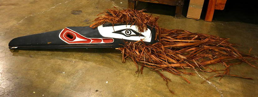
Sold2019Native American Pacific Northwest raven dance mask withNative American Pacific Northwest raven dance mask with raffia chest, 20th Century, having a hinged beak accented with red, black and white pigment, 7"h x 33"lSee Sold Price
Sold2023Clarence Wells, Haida Pacific Northwest Coast Painted Cedar BoxClarence Wells, Haida Pacific Northwest Coast Painted Cedar Box . Signed Clarence Wells. Approximately 9.375W x 8.0H x 7.5D in.See Sold Price
Sold2023Pacific Northwest Painted Cedar BoxNorth West Coast Native American Painted Wooden Box. Approximately 8.25H x 7.5W x 7.375D in.See Sold Price
Sold2023Two Pacific Northwest Native American Woven Baskets or Trays2 Northwest Coast Native American Woven Baskets. Larger Approximately 8.5L x 6.125W in. Smaller Approximately 7.625L x 5.25W in.See Sold Price
2 days LeftJasper521699 Moll World Map with Cowley's Voyages -- Nouvelle Carte du Monde Suivant l'idee de Mercator ouUS$240
3 days LeftJasper52PACIFIC OCEAN.Depth.Surface isotherms.HMS Challenger expedition track 1898 mapUS$15
3 days LeftJasper52World War 2. Guadalcanal Campaign 7-8 Aug 1942 Tulagi Landing Schedule 1959 mapUS$10
3 days LeftJasper52World War 2. Guadalcanal Campaign 7-8 Aug 1942 Landing. Henderson Field 1959 mapUS$10
3 days LeftJasper52Polynesia. Fiji, Hawaiian & Samoan islands. Vanua/Viti-Levu. THE TIMES 1895 mapUS$40
3 days LeftJasper52World War 2. Guadalcanal Campaign. Landing 7 Aug 1942 & Concurrent Ops 1959 mapUS$10
3 days LeftJasper52The body of Tee, a chief, preserved after death in Otaheite. Tahiti. BANKES 1789US$8


![[PACIFIC NORTHWEST]. Two pictorial maps of Oregon and Washi...: [PACIFIC NORTHWEST]. Two pictorial maps of Oregon and Washington. Including: -- PETRUCCELLI, Antonio (1907-1994). Pictorial map of Washington and Oregon. 1940. Art Deco style map of the Pacific Northw](https://p1.liveauctioneers.com/928/255324/132836177_1_x.jpg?height=310&quality=70&version=1658268357)