Sold2016[Wall map] FranceCarte de la France, 1790.Incisione in coloritura coeva, 1200x1160 mm.See Sold Price
Sold20241844 Siege of Gibraltar American Revolution SPAIN France Drinkwater MAP History1844 Siege of Gibraltar American Revolution SPAIN France Drinkwater MAP History In 1779, during the American Revolutionary War, French and Spanish forces attempted to capture and hold Gibraltar, whichSee Sold Price
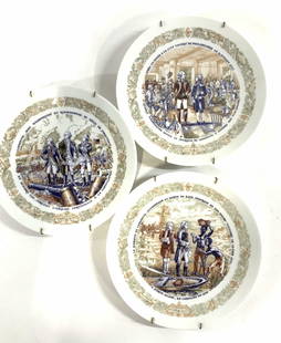
Sold2023Limoges France American Revolution Wall Plates, 3Signed and Numbered Limited edition collectible porcelain plates with historical men of the American Revolution - George Washington, Marquis de Lafayette and Comte de Rochambeau at Battle of Yorktown,See Sold Price
Sold2023Limoges France American Revolution Wall Plates, 3Signed and Numbered Limited edition collectible porcelain plates with historical men of the American Revolution - George Washington, Marquis de Lafayette and Comte de Rochambeau at Battle of Yorktown,See Sold Price
Sold2017Revolutionary France with 13 Belgian & 6 PiedmontTitle/Content of Map: 'France [in departments during the Revolution]' This fascinating map shows France in departments during the Revolutionary period. In addition to the territory occupied by modern-See Sold Price
Sold20201790 French Revolutions de Paris Departments France1790 French Revolutions de Paris Departments France MAPS Pas de Calais Louis Marie Prudhomme was an 18th-century French historian who is known for his satirical and sarcastic articles on the French ReSee Sold Price
Sold2023Joseph Forest large map of France with train line and navigable river 1919In 1886, Forest founded his publishing house of maps and plans, mappemondes, globes, terrestrial and celestial spheres, paintings and wall maps for education at 17-19, rue de Buci in Paris and remainsSee Sold Price
Sold20231902 National Publishing Company Wall Map1902 roll down wall map printed by the National Publishing Company New Railroad, Post office, Township, and County Map of New York which measures approximately 48" by 41". Condition - fine.See Sold Price
Sold20181850 1st ed France and Its Revolutions Illustrated1850 1st ed France and Its Revolutions Illustrated French Politics MAP Portraits An incredible 1850 printing of Charles Long’s ‘France and its Revolutions’ – a unique English account of FrenchSee Sold Price
Sold20181790 French Revolutions de Paris Prudhomme Rhine MAP1790 French Revolutions de Paris Prudhomme Rhine MAP Illustrated LaFayette France Louis Marie Prudhomme was an 18th-century French historian who is known for his satirical and sarcastic articles on thSee Sold Price
Sold20181791 French Revolutions de Paris Prudhomme MAPS Illustr1791 French Revolutions de Paris Prudhomme MAPS Illustrated LaFayette France Louis Marie Prudhomme was an 18th-century French historian who is known for his satirical and sarcastic articles on the FreSee Sold Price
Sold20191791 1ed French Revolutions de Paris Prudhomme MAPS1791 1ed French Revolutions de Paris Prudhomme MAPS Illustrated LaFayette France Louis Marie Prudhomme was an 18th-century French historian who is known for his satirical and sarcastic articles on theSee Sold Price
Sold2016LALIQUE 'SEVILLE' FROSTED GLASS SCONCES PAIRLALIQUE 'SEVILLE' FROSTED GLASS SCONCES, PAIR, H 15":Each frosted glass wall sconce with volute motif, silver chrome hardware and finials to terminals. Signed "Lalique France" (see photo), post 1945.See Sold Price
Sold2022China.- Shanghai.- Kelly & Walsh (Shanghai-based publishers) Map of Shanghai, lithograph printed inChina.- Shanghai.- Kelly & Walsh (Shanghai-based publishers, active 1876 to 20th century) Map of Shanghai, English-language map showing pre-Communist revolution Shanghai but post World War II, lithogrSee Sold Price
Sold20181788 France Dulaure Atlas MAPS Provence Poitou Castles1788 France Dulaure Atlas MAPS Provence Poitou Castles French Revolution era Jacques-Antoine Dulaure was an 18th-century French historian known for his descriptive work on the important geographic plaSee Sold Price
Sold20231902 Map of Vermont Highways, Natural Features, Railroad Stations, etc...This is a large, wall hanging 1902 Complete Map of Vermont Showing Highways and Natural Features, with an Index of All Cities, Villages, Post Offices, and Railroad Stations. Railroad routes are also sSee Sold Price
Sold2023M.G. LOVELAND MILITARY PHOTO POST CARDS & DIARYSgt. Loveland, 19th Regiment U.S. Marines, photo album: Cuba, France, NY, Virginia, Mexico (1914 Revolution), Panama Canal; sinking of the "Maine" and its victims being loaded onto U.S.S. North CaroliSee Sold Price
Sold2019Guillaume de Lisle (French, 1675-1726) - Orbis RomaniGuillaume de Lisle (France, 1675-1726) - Orbis Romani descriptio seu divisio per themata sub Imperatoribus Constantinopolitanis post Heraclii tempora facta Map, Amsterdam, 1742. Published by Covens anSee Sold Price
Sold20151845 MITCHELL'S REFERENCE & DISTANCE WALL MAP U.S.SHOWING MITCHELL'S 1845 REFERENCE AND DISTANCE WALL MAP OF THE UNITED STATES WITH GENERAL MAP OF THE US WITH CONTIGUOUS BRITISH AND MEXICAN POSSESSIONS.PHILADELPHIA : S. AUGUSTUS MITCHELL COPPER-ENGRASee Sold Price
Sold2024BRUE'S MONUMENTAL WALL MAP OF TEXAS, UPPER CALIFORNIA & MEXICO, C. 1845Title: "Nouvelle Carte du Mexique, Du Texas et d’une Partie des Etats Limitrophes." Engraving with original hand-color. Paper size: 39 - 1/4” x 26 - 3/4”. The map shows the territorySee Sold Price
Sold2023Scarce 1854 wall map of N. America in exceptional condition, Jacob MonkSurprisingly clean and sound wall map of North America showing significant evolution of territories west of the Mississippi River following the Mexican-American War and during the height of the CalifoSee Sold Price
Sold2022Jacob Monk Wall Map of North America 1860Monk's Standard American Map exhibiting the larger portion of North America Embracing The United States and Territories, Mexico, Central America, including the West India Islands, Canada, New BrunswicSee Sold Price
Sold20181859 Clark & Tackabury Antique Connecticut Wall MapTitle/Content of Map: 1859 Clark & Tackabury Connecticut Wall Map -- Clark & Tackabury's New Topographical Map of the State of Connecticut Date Printed: 1859 Philadelphia Cartographer: Clark and TackaSee Sold Price
Sold2017Wall map of Marin County 1892Heading: (California - Marin County) Author: Dodge, George M. Title: Official Map of Marin County, California 1892 Compiled from Records and Surveys Place Published: San Francisco Publisher:Schmidt LaSee Sold Price
Jun 23East Coast Fine Arts LLC1777 US Revolutionary War Map French Brion de la Tour Theatre de GuerreUS$1,000
BonhamsFRENCH REVOLUTION - LOUIS XVI Document signed and subscribed by the King ('Bon Louis'), Paris, 2...£850(2 bids)
BonhamsBURKE (EDMUND) Reflections on the Revolution in France, Dublin, 1790; PAINE (THOMAS) Rights of M...£400
BonhamsWOLLSTONECRAFT (MARY) A Vindication of the Rights of Men, FIRST EDITION, 1790; BURKE (EDMUND) Re...£1,800
BonhamsMANUSCRIPT JOURNAL – WATERLOO, SOUTH AFRICA and INDIA Manuscript journal of Edward Nugen...£800(3 bids)
Featured4 days LeftJasper521950s French Post Impressionist Signed Oil Painting Vibrant Still Life Anemonies 1950US$650
926 Lots AwayBazaar of PersiaChina Stamp 1901 French Post Office Tablet Issue Opted HoiHao part set of 13 MNHUS$100
4 days LeftJasper52Olive Groves in Provence Original French Post Impressionist Signed Oil 1960's 1960'sUS$850
4 days LeftJasper521950s French Post Impressionist Oil Self Portrait the Artist Unfinished Sketch 1950sUS$170
4 days LeftJasper521930's French Post Impressionist Oil Painting Figure Lady Reclining in MeadowUS$1,100
4 days LeftJasper521950s French Post Impressionist Watercolor Painting Pink Chrysanthemum Flowers 1950sUS$280


![[Wall map] France: Carte de la France, 1790.Incisione in coloritura coeva, 1200x1160 mm.](https://p1.liveauctioneers.com/3336/90951/46934974_1_x.jpg?height=310&quality=70&version=1473763184)


![Revolutionary France with 13 Belgian & 6 Piedmont: Title/Content of Map: 'France [in departments during the Revolution]' This fascinating map shows France in departments during the Revolutionary period. In addition to the territory occupied by modern-](https://p1.liveauctioneers.com/5584/112867/57947726_1_x.jpg?height=310&quality=70&version=1511920104)


![[Woman traveller - French Revolution] (1 of 1)](https://p1.liveauctioneers.com/94/330664/178342176_1_x.jpg?height=282&quality=70&version=1716466933)


