Sold2016Map of Bermuda Islands, 1902Title: Map of Bermuda Islands Original engraving by George Cram Date: 1902 Dimensions: 11 x 14 inches No Reserve: This lot starts at $1 and has no reserve as a courtesy so that collectors can determinSee Sold Price
Sold2021Bermuda Islands 1897Title/Content of Map: Bermuda Islands 1897 Date Printed: 1897Material/Medium: Paper Size: approx. 11x14 inches Crams Universal Atlas- Chicago Reserve: $30.00 Shipping: Domestic: Flat-rate of $15.00See Sold Price
Sold2023Herman Moll, Map of Bermuda, 1729Herman Moll, Map of Bermuda, 1729, "The Island of Bermudos Divided into its Tribes, with the Castles, Forts, &c", hand-colored engraving on paper, gallery stamps verso, matted and framed under glass,See Sold Price
Sold2016Map of New Zealand, South Island, 1902Title: Map of New Zealand, South Island (Chatham & Tasmania) Original engraving by George Cram Date: 1902 Dimensions: 11 x 14 inches Description: Features insets of Chatham Islands & Tasmania on Van DSee Sold Price
Sold2016Map of New Zealand, North Island, 1902Title: Map of New Zealand, North Island Original engraving by George Cram Date: 1902 Dimensions: 11 x 14 inches No Reserve: This lot starts at $1 and has no reserve as a courtesy so that collectors caSee Sold Price
Sold2016Map of West Indies, 1868Original engraving from Johnson's Atlas of the World, 1868. Map includes vignette of the Bermuda Islands & details cities, towns and territories. Dimensions: 18" x 26". This item ships from Ocean ViewSee Sold Price
Sold2023Johnson's West Indies. Bermuda Islands. Caribbean Bahamas Antilles 1866 mapTitle: Johnson's West Indies. Bermuda Islands. Caribbean Bahamas Antilles 1866 map Description: Johnson's West Indies // The Bermuda Islands' by Alvin Jewett Johnson (1866). Large, decorative hand colSee Sold Price
Sold20231902 Cram Map of Long Island -- Map of Long Island New YorkTitle: 1902 Cram Map of Long Island -- Map of Long Island New York Cartographer: G Cram Year/Place: 1902, Chicago Dimensions: 9.8 X 12.4 in. Description: This is an attractive map of Long island withSee Sold Price
Sold2017Tallis: Map of Islands of the Atlantic, 1853Islands of the Atlantic - Bermuda, Canary & Azores by Tallis. Original lithograph by John Tallis & Company of London, c. 1853. Map features Azores, Madeira, Bermuda, Canary & Cape Verde Islands. VingnSee Sold Price
Sold2021Tallis, John (Pub) 1852 Map. Islands in the AtlanticShowing Canary Islands, Madeira and Bermuda. Steel Engraved Map with Original Outline Hand Color Published 1852-56 by John Tallis, London for "The Universal Pronouncing Dictionary" by Thomas Wright. DSee Sold Price
Sold2022Sharp 1875 map of W. Indies/Central AmericaDetailed map of Central America and the Caribbean, hand colored by islands. Includes an inset of the Bermuda Islands. Very nice representation of topography on all of the land masses in the map. An exSee Sold Price
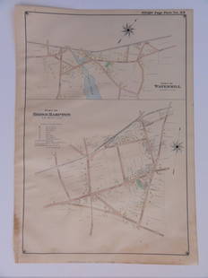
Sold2016Bridgehampton & Watermill, Long Island, 1902Original engraving published by E. Belcher Hyde from "Atlas of Suffolk County, Long Island, New York," Philadelphia, 1902. Map features family names, historic buildings and railroad routes. DimensionsSee Sold Price
Sold2022[BERMUDA] Pair of vintage map posters. Including:[BERMUDA] Pair of vintage map posters. Including: PETRUCCELLI, A. Bermuda. 1966. 24 1/8 x 39 5/8”. Linen backed. Minor repaired tears in margins. – The Bermuda Islands. USA: Bermuda TradeSee Sold Price
Sold2019ATLANTIC ISLANDS. Bermuda Madeira Canaries.TenerifeTITLE/CONTENT OF MAP: 'Islands in the Atlantic' The map shows the islands of Madeira, the Azores, the "Bermudas or Summers Islands", the Canary Islands and teh Cape de Verde Islands. Vignettes: Fayal,See Sold Price
Sold2023CARIBBEAN/ATLANTIC ISLANDS.Jamaica Bermuda Bahamas Trinidad. JOHNSTON 1899 mapTitle: CARIBBEAN/ATLANTIC ISLANDS.Jamaica Bermuda Bahamas Trinidad. JOHNSTON 1899 map Description: Jamaica, Bahamas, Trinidad, and Bermudas' by Johnston, W & AK (1899). Colour antique map, 26.5 x 20.5See Sold Price
Sold2023CARIBBEAN/ATLANTIC ISLANDS.Jamaica Bermuda Bahamas Trinidad. JOHNSTON 1900 mapTitle: CARIBBEAN/ATLANTIC ISLANDS.Jamaica Bermuda Bahamas Trinidad. JOHNSTON 1900 map Description: Jamaica, Bahamas, Trinidad & Bermudas' by W. & A.K. Johnston, Limited, Edinburgh & London (1900). AntSee Sold Price
Sold2022Frank Lemen (1902-1985), Bermuda Poster, c. 1952Property from a Private Collection Hilton Head Island, SC Description: Frank Lemen (1902-1985), Bermuda, c. 1952, signed lower right, Mardon, Son & Hall, Ltd., Bristol. Linen size 39 7/8. in. x 26See Sold Price
Sold2017Homann: British West Indies/Atlantic Islands Map, 1740Map: Dominia Anglorum. British West Indies/Atlantic islands of St Christopher (St Kitts), Antigua, Bermuda, Jamaica & Barbados Date Printed: c1740 Image Size: Approx 52.5 x 59.5cm, 20.5 x 23.25 inchesSee Sold Price
Sold2022Jose Formoso Reyes Nantucket Friendship Basket with Carved Nantucket Island on the LidJose Formoso Reyes (1902-1980) Nantucket Friendship Basket with Carved Nantucket Island on the Lid, signed upon the base "Made in Nantucket, Jose Formoso Reyes 1966" with outline map of Nantucket IslaSee Sold Price
Sold2016Carolina & Bermuda 1716Map Title: Carolina & The Island Bermudos Maker: Herman Moll Date: 1716 Origin: Atlas Geographicus Size: 13 x 16 inches Medium: Copperplate engraving Herman Moll (1654-1732) was a London cartographer,See Sold Price
Sold2018Homann Heirs: British Caribbean and Atlantic IslandsDominia Anglorum in praecipuis Insulis Americae On one sheet, five highly detailed maps of British possessions in the Caribbean and Atlantic: St. Kitts, Antigua, Bermuda, Barbados, and Jamaica. St. KiSee Sold Price
Sold2024MAP, Bermuda, HondiusBermuda. Henricus Hondius, Mappa Aestivarum Insularum, Alias Barmudas Dictarum, ad Ostia Mexicani Aestuary..., from Newer Atlas..., 1638 (circa). Hand Color. A striking map based on the famous surveySee Sold Price
Sold2017Neele: Antique Map Islands of the Pacific Ocean, 1817Map: Map of the Islands in the Pacific Ocean Publication Date: 1817 Cartographer: NEELE, sc. Publisher: THOMSON'S NEW GENERAL ATLAS Size: Folio – 19.50 H x 23.75 W Inches From a famous Scottish atlaSee Sold Price
Featured4 days LeftJasper521750 Bowen Map of Bermuda and St. Kitts -- A New & Accurate Map of Bermudas or Sommer's Islands...US$600
Featured4 days LeftJasper521630 Mercator Map of Bermuda -- Mappa Aestivarum Insularum Alias Bermudas Dictarum ad Ostia MexicaneUS$320
5 days LeftJasper52SOUTH AMERICA NORTHERN.Brazil Peru Ecuador Colombia Venezuela.JOHNSTON 1906 mapUS$8
5 days LeftJasper52SOUTH AMERICA NORTHERN Brazil Peru Ecuador Colombia Venezuela JOHNSTON 1901 mapUS$8
Jun 08Leon GalleryRobert Dudley (1573 - 1649) - Carta particolare del'Isola Mindano parte Australe con Celebes e₱500,000
22 hrs LeftTrillium Antique Prints & Rare BooksSanson - Map of the Sunda Islands, Sumatra, Java, & BorneoUS$75
5 days LeftChampagne AuctionsWORLD 1941-2011. A Massive Accumulation of Over 4800 Modern Coins Fine-UncCA$260(1 bid)
4 days LeftJasper521720 Chatelain Map of Scotland -- Nouvelle Carte d'Ecosse, ou l'on Fait Observer l'Etat de la NoblesUS$240
22 hrs LeftTrillium Antique Prints & Rare BooksSanson - Map of the Philippines and Ladrones IslandsUS$75
22 hrs LeftTrillium Antique Prints & Rare BooksDe Jode, Rare, pub. 1593 - Map of Europe (Nova Totius Europae Tabula)US$210(4 bids)


![[BERMUDA] Pair of vintage map posters. Including:: [BERMUDA] Pair of vintage map posters. Including: PETRUCCELLI, A. Bermuda. 1966. 24 1/8 x 39 5/8”. Linen backed. Minor repaired tears in margins. – The Bermuda Islands. USA: Bermuda Trade](https://p1.liveauctioneers.com/928/230548/119288256_1_x.jpg?height=310&quality=70&version=1639776029)


