Sold20172 Framed World Maps including Blaeu Wall Map2 Framed World Maps including Blaeu Wall Map. Largest measures 22 x 26 inches.See Sold Price
Sold2021Framed World MapFramed World map, Blaeu wall map, color print with areas of silvered paper, double matted in mahogany finish 25" x 29" frame. Condition; very goodSee Sold Price
Sold2021Vintage Wall Art Maps- World and NewportTwo Vintage Wall Art Maps- World Map printed in 1930's by Hendrik Willem Van Loon and 1957 Newport Rhode Island Map. Both Framed. Measure 23" x 19 1/2" and 23" x 18". Condition: GoodSee Sold Price
Sold2024Framed Map AssortmentFramed Map Assortment (8) items with (3) maps by Willem Blaeu (Dutch, 1571-1638) including c.1660 'Tirolensis', 'Gastinois et Hurepois' and 'Hannoniae et Namurci', (2) maps by Robert de Vaugondy (FrenSee Sold Price
Sold2023(23+) MEN'S OFFICE DOLLHOUSE MINIATURES(1) folding wood library ladder; (1) framed map; (3) duck decoys; (9) books including photo album and yellow pages; (1) newspaper; (2) framed glass painted wall art; (6) desk items - metal phone, binoSee Sold Price
Sold2016Two Framed Hand-colored Engraved Maps, 19th/20thTwo Framed Hand-colored Engraved Maps, 19th/20th Century, Including a map of Morea olim Peloponnesus by Gerardus Mercator and of Deventer by Johannes Blaeu. Largest framed dimensions: h: 21 1/2 x w: 2See Sold Price
Sold2022A FRAMED ANTIQUE CHINESE MAP ON PAPERColor and ink on paper, the map depicting the area south of great wall of china, also including korea, parts of Japan, and Vietnam Early Qing Dynasty period. Height: 18 1/2 in (47.0 cm) Width: 15 in (See Sold Price
Sold20212) STIELER & MITCHELL MAPS EUROPE, TURKEY & GREECE(lot of 2) Framed maps, including: (1) engraving with hand coloring on paper, German map of Europe, Turkey, Greece, and the Ionian Islands, from "Stielers Schul-Atlas," published by Justus Perthes, GoSee Sold Price
Sold2020Framed Blaeu Wall Map Gold FoilFramed Blaeu Wall Map Gold Foil Roughly 25.5" x 32"See Sold Price
Sold20212 FRAMED MAPSTWO FRAMED MAPS INCLUDING EASTON PA, PHILLIPSBURG. LARGEST MAP HAS DAMAGE TO UPPER LEFT & NO GLASS BY SW ROCKWELL. 36 3/4 IN X 37 1/2 IN INCLUDING FRAMESee Sold Price
Sold2023Royal Geographical Society Silver Map #2. Framed Engraved Metal World Map. PTOLEMY version. Issued bRoyal Geographical Society Silver Map #2. Framed Engraved Metal World Map. PTOLEMY version. Issued by the FRANKLIN MINT; Limited Edition. 1976. Thin sterling sheet laid on wood. Deaccessioned from TheSee Sold Price
Sold2023Large Brass 1628 World Map Wall Art by MasketeersThis impressive piece of wall art is a reproduction of a 1628 world map, created by Masketeers, Inc. in 1963. Measuring a substantial 43 1/2" by 30 1/2", it is a striking addition to any space. CrafteSee Sold Price
Sold2016Map LotLot (3) framed maps including "Carte De La Baye De Hudson" (sight 9 1/4" x 12 1/4"), "The River St. Laurence" (sight 10" x 14 1/2"), "A Plan of the City and Harbour of Louisburg" (sight 11" x 14 1/2")See Sold Price
Sold2022Map LotLot (5) framed maps including: "LE PAYS DES HOTTENTOTS…" (sight 10 1/2", overall 14 1/2" x 18"), "COLONY of the / CAPE of GOOD HOPE" (sight 8 1/2" x 11", overall 13 1/2" x 17"), Map of Central PSee Sold Price
Sold2023Map LotLot (3) framed maps including "PLAN DU CENTRE DE PARIS VOLD' OISEU" (overall in frame 28" x 38 1/2"), Spain (overall 25" x 34 1/2"), "GALLACIA REGNUM" (overall 21" x 23").See Sold Price
Sold2022Two framed wall maps. Oarsmans map of the River Thames, 87 x 46cm, and Bacon's Excelsior Map ofTwo framed wall maps. Oarsmans map of the River Thames, 87 x 46cm, and Bacon's Excelsior Map of Norfolk and Suffolk, 113 x 89cm (2)See Sold Price
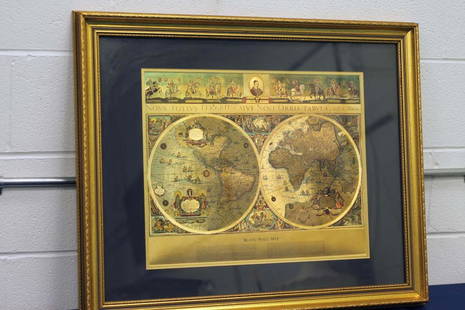
Sold2024Blaeu Wall MapNova Totivs Terrarom Sive Novi Orbis Tabvla and G. Blaeu. Sight: 15-1/2" high x 19-1/2" wide. Overall with frame: 18" high x 22" wide. LRSee Sold Price
Sold2023Group of 4 Early European MapsGroup of 4 early framed European maps, including; 'De L'Europe, figure III., Isle D'Albion", 'Westmorland', 'Wien in Oesterreich' and 'Milan'. Measures: 12" x 15 1/2" overall, largest.See Sold Price
Sold2022An 1882 Black's General Atlas of the WorldAn 1882 Black's General Atlas of the World; including maps of countries in the world, and the states in United state of America, all edge gold, 2.1"x18.2"x13.7"See Sold Price
Sold2017Blaeu Map of BrazilMaritima Brasiliae Universa. Joan Blaeu (1596-1673). Engraved map with original color in part. Amsterdam: Blaeu, 1647. 21 x 24 1/2 inches sheet, 32 1/2 x 36 inches framed. This separately issued and rSee Sold Price
Sold2017Framed Colored Engraved 17th C. World Map"Nova Totius Terrarum Sive Novi Orbis Tabula" Framed Colored Engraved 17th C. World Map by Willem Janszoon Blaeu - This interesting piece is an early world map created by Willem Janszoon Blaeu. The maSee Sold Price
5 hrs LeftJasper521816 MAP NORTHERN PART OF RUSSIA or MUSCOVY in EUROPE copper engraving ANTIQUEUS$35
5 days LeftArarity AuctionsThomson's 1817 Hand Colored Map Comparative Heights of the World's Great MountainsUS$50
Jun 08Leon GalleryRobert Dudley (1573 - 1649) - Carta particolare del'Isola Mindano parte Australe con Celebes e₱500,000
4 days LeftTrillium Antique Prints & Rare BooksSanson - Map of the Philippines and Ladrones IslandsUS$75
4 days LeftTrillium Antique Prints & Rare BooksSanson - Map of the Sunda Islands, Sumatra, Java, & BorneoUS$75
20 hrs LeftThomaston Place Auction GalleriesCOLLECTION OF TRAVEL EPHEMERA, BROCHURES, BOOKLETS, MAPS 1900-1950US$100
1 day LeftJasper52South-East Asia. Indochina in 1944. Ports. World War 2 naval campaigns 1961 mapUS$8
1 day LeftJasper52WORLD WAR 2 Japanese occupied Philippines Malaya Indochina Thailand 1942 mapUS$55(1 bid)
2 days LeftForum AuctionsVoyages.- Dampier (William) A New Voyage Round the World... the Isthmus of America..., vol.1 (of 4),£75


![[MAP]. ORTELIUS, Abraham. Africae Tabula Nova. 1592. (1 of 2)](https://p1.liveauctioneers.com/197/329395/177650533_1_x.jpg?height=282&quality=70&version=1715364962)


