Sold2019Hindoostan.Title: Hindoostan. Publication Date: 1834 Cartographer: G. Boynton Publisher: Samuel WalkerSize: 9.3Height - 7.75Width Attractive map from System of Geography by M. Malte Brun containing a descriptionSee Sold Price
Sold2018SicilyReserve Reduced! Title/Content of Map: SicilyDate: 1834 Cartographer: G. Boynton Material/Medium: SAMUEL WALKER Size: 7.65 x 9.5 inches Attractive map from System of Geography by M. Malte Brun containSee Sold Price
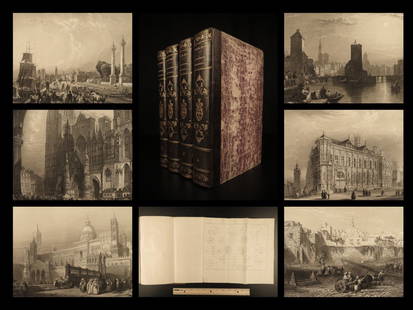
Sold20221841 BEAUTIFUL Geography by Malte-Brun Illustrated1841 BEAUTIFUL Geography by Malte-Brun Illustrated Jerusalem Edinburg Ruins 4v Conrad Malte-Brun was a French geographer and cartographer known for his impressive journal-like atlases and geography boSee Sold Price
Sold2017Malte-Brun: Map of Asia, 1830Map: Asia Maker: John Grigg, Malte-brun, Conrad/j. H. Young, Sc. Publication Date: 1830 Publisher: John Grigg Size: Quarto – 8.00 H x 9.75 W Inches From Malte-Brun's "A new General atlas, exhibitingSee Sold Price
Sold2017Malte-Brun: Antique Map of Northern Africa, 1812Map: 1812 Malte-Brun Map of Northern Africa -- Afrique Ancienne Cartographer: M Malte-Brun Year / Place: 1812, Paris Map Dimensions: 8.7 X 12.7 in. Condition: Very Good - Excellent. Color outlined onSee Sold Price
Sold20171812 Malte-Brun Map of Siberian and Alaskan RussiaTitle: 1812 Malte-Brun Map of Siberian and Alaskan Russia -- Siberie avec lAmerique RussePartie Meridionale de la Russie d'Europe Cartographer: M Malte-Brun Origin/Date: 1812, Paris Size: 8.7 inches XSee Sold Price
Sold2017Malte-Brun: Map of Europe, Barbarian Invasions, 1811Map: 1811 Malte-Brun Map of Europe during the Barbarian Invasions -- L'Europe apres l'invasion des Barbares Cartographer: M Malte-Brun Year / Place: 1811, Paris Map Dimensions: 8.7 X 11.7 An outstandiSee Sold Price
Sold2017Malte-Brun: Antique Map of the World per Herodotus 1812Title/Content of Map: 1812 Malte-Brun Map of the Known World per Herodotus -- Geographie d'Herodote Date Printed: 1812, Paris Cartographer: M Malte-Brun Size: 8.7 X 11.7 in. An excellent and very inteSee Sold Price
Sold2018Malte-Brun: Antique Map of Central Oceanica, 1830Title/Content of Map: Central Oceanica Date Printed: 1830 Cartographer: MALTE-BRUN, CONRAD/J. H. YOUNG, sc. Size (inches): 7.5x7.5 From Malte-Brun's "A new General atlas, exhibiting the five great divSee Sold Price
Sold2017Malte-Brun: Antique Map of Europe in 1829Title/Content of Map: 1829 Malte-Brun Map of Europe in 1829 -- Europe en 1829 Date Printed: 1829, Paris Cartographer: M Malte-Brun Size: 8.7 X 11.7 in. An attractive map of Europe showing its politicaSee Sold Price
Sold20171834 Malte-Brun Map of Ireland1834 Malte-Brun Map of Ireland -- Ireland. M. Malte-Brun / S. Walker. 1834, Boston. 9.3 x 7.5 in. An attractive and highly detailed map with topographical and settlement details. From the American ediSee Sold Price
Sold2017Malte-Brun: Map of Europe during Hun invasion in 370Map: 1812 Malte-Brun Map of Europe during the Hun invasion in 370 -- L'Europe avant l'invasion des Huns vers l'an 370 Date Printed: 1812, Paris Cartographer: M Malte-Brun Size: 8.7 X 11.7 in. ConditioSee Sold Price
Sold20171812 Malte-Brun Map of the Known WorldTitle: 1812 Malte-Brun Map of the Known World -- Systemes Geographiques de Ptolemee… Cartographer: M Malte-Brun Origin/Date: 1812, Paris Size: 8.7 inches X 11.7 inches An excellent and very interestSee Sold Price
Sold2017Malte-Brun: Antique Map of Italy, 1834Title/Content of Map: 1834 Malte-Brun Map of Italy -- Italy Date Printed: 1834, Boston Cartographer: M. Malte-Brun / S. Walker Size: 9.3 x 7.5 in. An attractive and highly detailed map with topographiSee Sold Price
Sold2017Malte-Brun: Antique Double Map of Europe in 1500 & 1789Title/Content of Map: 1812 Malte-Brun Map Double Map of Europe in 1500s and 1789 -- Europe sons Charles-Quint [together with] Europe en 1789 Date Printed: 1812, Paris Cartographer: M Malte-Brun Size:See Sold Price
Sold2017Malte-brun: Double Map of Europe in 900 and 1100, 1812Malte-brun Map Double Map of Europe in 900 and 1100 -- Europe En 900 [together With] Europe En 1100. 1812, Paris. 8.7 X 11.7 in. An interesting double map of Europe in the middle ages -- 900 and 1100.See Sold Price
Sold2017Malte-Brun Map of the Spice Islands, 18341834 Malte-Brun Map of the Spice Islands -- East India Islands (S China Sea). An attractive and highly detailed map the East India Islands with topographical and settlement details. From the AmericanSee Sold Price
Sold20201812 Malte-Brun Map of Ancient Civilized World -- MondeTitle/Content of Map: 1812 Malte-Brun Map of Ancient Civilized World -- Monde Connu des Anciens Cartographer: M Malte-Brun Year/Place: 1812, Paris Size: 8.7 X 11.7 in. An excellent map showing the geoSee Sold Price
Sold20191812 Malte-Brun Map of Germany -- Confederat du RhinTitle/Content of Map: 1812 Malte-Brun Map of Germany -- Confederat du Rhin Date: 1812, Paris Cartographer: M Malte-Brun Size: 11.7 x 8.8 in. An attractive map of German states, showing its political dSee Sold Price
Sold2017Malte-Brun: Antique Map of Sicily, 1834Map: 1834 Malte-Brun Map of Sicily -- Sicily Cartographer: M. Malte-Brun / S. Walker Year / Place: 1834, Boston Dimensions: 9.3 x 7.5 in. Condition: Very Good. Nice strike, slight toning and foxing AnSee Sold Price
Sold20181834 Malte-Brun Map of Asia -- AsiaTitle/Content of Map: 1834 Malte-Brun Map of Asia -- Asia Date Printed: 1834, Boston Cartographer: M. Malte-Brun / S. Walker Size: 9.3 x 7.5 in. An attractive and highly detailed map with topographicaSee Sold Price
Sold2017Malte-Brun: Antique Map of England & Wales, 1834Map: 1834 Malte-Brun Map of England and Wales -- England and Wales Cartographer: M. Malte-Brun / S. Walker Year / Place: 1834, Boston Map Dimensions: 9.3 x 7.5 in. Condition: Very Good. Nice strike, sSee Sold Price
Sold20201812 Malte-Brun Map of Scandinavia -- Danemark Suede etTitle/Content of Map: 1812 Malte-Brun Map of Scandinavia -- Danemark Suede et Norwege Cartographer: M Malte-Brun Year/Place: 1812, Paris Size: 11.7 x 8.8 in. A handsome map of Scandinavia. Finland isSee Sold Price
Sold20171812 Malte-Brun Double Map of Europe in 1500s and 1789Item: 1812 Malte-Brun Double Map of Europe in 1500s and 1789 Description: An interesting double map of Europe in the the period of Charles V's reign in the first half of 1500s and Europe in 1789. MostSee Sold Price
6 days LeftJM Hobby Supply and Railroad Artifact AuctionsG Gauge Brass Passenger Car with Sierra Sound SystemUS$50(1 bid)
Crawford Family Auctions LLCVintage Nakamichi 550 Dual-Tracer Versatile Stereo Cassette System w/ Accessories. Untested. SeeUS$20
Jul 10Bodnar's Auction SalesLot of 2 Vintage Bell System Western Electric Rotary TelephonesUS$20(2 bids)
4 days LeftRail & Road Auctions8 Diesel locomotive Marking and Trust Plates - Chessie System, W.F. George, Wachovia TrustUS$20
16 hrs LeftFreeman's | Hindman[Arms & Armor] Burton, Richard F.: A New System of Sword Exercise for InfantryUS$1,200
3 days LeftRail & Road AuctionsGroup of Four New York Central System / Big Four Railroad Cap BadgesUS$60(2 bids)
Jul 10Bodnar's Auction SalesLot of 2 Vintage Bell System Western Electric Rotary TelephonesUS$10(1 bid)
4 days LeftSouth Florida Auction & Estate Sale Services IncSuperman Promo Poster for the Original Atari Game SystemUS$6(1 bid)
3 days LeftRail & Road AuctionsNew York Central System Railroad Items - Mercury China Plate, Boston & Albany Timetables, Locks,US$30


![Malte-Brun: Antique Double Map of Europe in 1500 & 1789: Title/Content of Map: 1812 Malte-Brun Map Double Map of Europe in 1500s and 1789 -- Europe sons Charles-Quint [together with] Europe en 1789 Date Printed: 1812, Paris Cartographer: M Malte-Brun Size:](https://p1.liveauctioneers.com/5584/112159/57581953_1_x.jpg?height=310&quality=70&version=1510710796)
![Malte-brun: Double Map of Europe in 900 and 1100, 1812: Malte-brun Map Double Map of Europe in 900 and 1100 -- Europe En 900 [together With] Europe En 1100. 1812, Paris. 8.7 X 11.7 in. An interesting double map of Europe in the middle ages -- 900 and 1100.](https://p1.liveauctioneers.com/5584/102658/52470396_1_x.jpg?height=310&quality=70&version=1492118289)


![[Arms & Armor] Burton, Richard F.: A New System of Sword Exercise for Infantry (1 of 4)](https://p1.liveauctioneers.com/65/332523/179335022_1_x.jpg?height=282&quality=70&version=1717622830)


