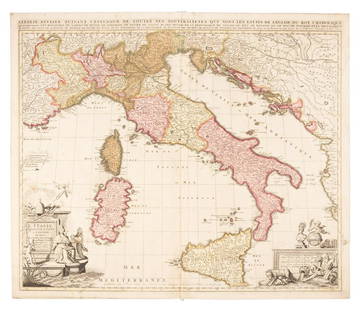
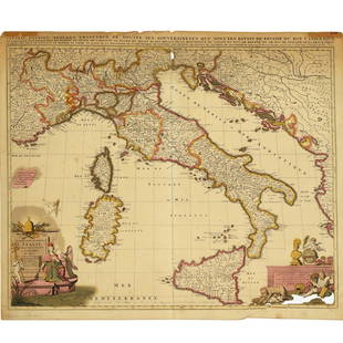
Sold2019Sanson map of Italy 1701Heading: Author: Sanson, Nicolas Title: L'Italie Divisee Suivant l'Estendue de Toutes ses Sourverainetes... Place Published: Amsterdam Publisher:Pieter Schenk Date Published: 1701 DescSee Sold Price
Sold2022Nicolas Sansom, map of Italy, 1701Nicolas Sansom, map of Italy, 1701, "L'Italie Divisee Suivant l'Estendue de Toutes ses Sourverainetes…", Pieter Schenk, Amsterdam, 1701, hand-colored copper plate engraving on laid paper, 20.25"See Sold Price
Sold2021Nicolas Sansom, map of Italy, 1701Nicolas Sansom, map of Italy, 1701, "L'Italie Divisee Suivant l'Estendue de Toutes ses Sourverainetes…", Pieter Schenk, Amsterdam, 1701, hand-colored copper plate engraving on laid paper, 20.25"See Sold Price
Sold2016Hubert Jaillot Sanson 1692 Map of ItalyFrame: 38" x 26" image sight: 36.25" x 24.25"See Sold Price
Sold2023Scarce and fine 1701 1st ed. map of Italy by Herman MollExcellent example of Moll’s 1701 map of Italy from the first edition of “A System of Geography.” A very scarce map with expertly applied modern full hand coloring according to politSee Sold Price
Sold20182 Maps: L’Italia + Italia Antiqua.[De Rossi/Sanson/Italy] 2 Maps. ++ Nicholas Sanson. Italia Antiqua cum Itineribus antiquis. Cum Insulis Sicilia Sardinia & Corsica. Rome: Jo. Jacob. De Rubeis. [C. 1690s.] At lower left: “Joannes L�See Sold Price
Sold2022Ancient Roman Republic era Italy. 1701-1706 by Christoph CellariusTitle: Ancient Roman Republic era Italy. 1701-1706 by Christoph Cellarius Date/Period: 1701-1706 Materials: Copperplate engraved Size: 13x9" The ancient Italy shown on this map is pre imperial. ProminSee Sold Price
Sold2016Map of Italy (Italia Antiqua of Oud Italje), 1704 HandElant, H., Engraved by, Map of Italy (Italia Antiqua of Oud Italje), 1704, Antique map of Italy and the islands Corsica, Sicily and Sardinia after N. Sanson, Published by Francois Halma, Engraving witSee Sold Price
Sold2021Jaillot 1681 Map of ItalyThis map by Jaillot originated by Nicholas Sanson, the cartographer's predecessor. It depicts the boot of Italy with Albania and Greece. The title cartouche is surrounded by two soldiers, horses, angeSee Sold Price
Sold2023MAP, Alps, SansonAlps - Italy, Switzerland, Austria. Nicolas Sanson, Le Tirol, souz le Nom Duquel s'Entendent le Comte de Tirol; puis les Comtes de Bregentz, Feldkirck, Montfort, Pludentz, &c. Sujets..., from Cartes GSee Sold Price
Sold20181683 Sanson Map of the Great Lakes and the Upper EastTitle/Content of Map: 1683 Sanson Map of the Great Lakes and the Upper East Coast -- Le Canada, ou Nouvelle France, &c. Tiree de diverses Relations des Francois, Anglois, Hollandois, &c. Date: 1683, PSee Sold Price
Sold20211683 Sanson Map Great Lakes to Newfoundland -- LeTitle: 1683 Sanson Map Great Lakes to Newfoundland -- Le Canada, ou Nouvelle France, &c. Tiree de diverses Relations des Francois, Anglois, Hollandois, &c. Cartographer: N Sanson Year / Place: 1683 c.See Sold Price
Sold20181683 Sanson Map of the Great Lakes and the Upper EastTitle/Content of Map: 1683 Sanson Map of the Great Lakes and the Upper East Coast -- Le Canada, ou Nouvelle France, &c. Tiree de diverses Relations des Francois, Anglois, Hollandois, &c. Date Printed:See Sold Price
Sold20231652 Sanson Map of the World -- L'Hydrographie ou Descriprion de L'Eau c'est a dire des Mers,Title: 1652 Sanson Map of the World -- L'Hydrographie ou Descriprion de L'Eau c'est a dire des Mers, Golfes, Lacs, Destroits, et Rivieres principales, qui font dans la Surface du Globe Terrestre . . .See Sold Price
Sold2022Alexis Hubert Jaillot and Nicolas Sanson - Map of the Grand Duchy of Moscow, Etching, 1708.Alexis Hubert Jaillot (French, 1632-1712) and Nicolas Sanson (French, 1600-1667) - Map of the White Russia or the Grand Duchy of Moscow, Etching, 1708. Title: Les Estats du Czaar de Russie Blanche ouSee Sold Price
Sold2020Nicolas Sanson Map of AsiaNicolas Sanson (1600-1667) "L'Asie divisee en ses Principales Regions, et ou se peuvent voir l'estendue, Des Empires, Monarchies, Royaumes, et Estats," Paris: Jaillot, ca. 1719. Hand colored map of AsSee Sold Price
Sold2024Sanson - Map of Canada or New France with the Great LakesThis strong map engraving is from the Dutch edition of Nicolas d'Abbeville Sanson's Cartes Generales de Toutes les Parties du Monde. The work was published in Utrecht in 1683 for the author. The atlasSee Sold Price
Sold2024Nicolas Sanson - Map of Asia / Asia divided into its Principal RegionsCopper engraving, 1600s/1700s, "Asia divided into its Principal Regions." By Mr. Sanson, Geographer Ordinary to the King. Size: 58 cm x 88 cm.See Sold Price
Sold2018RARE 17TH C. SANSON MAP OF LUXEMBOURGAlexis-Hubert Jaillot (c. 1632-1712); Nicolas Sanson (1600-1667) "Le Duche de Luxembourg Divise en Quarter Walon et Allemand....", hand colored engraving, published 1700 from earlier plates, Paris, frSee Sold Price
Sold20211652 Sanson Map of the Arabian Peninsula and the RedTitle: 1652 Sanson Map of the Arabian Peninsula and the Red Sea -- L'Arabie Petree, Deserte, et Heureuse Cartographer: N Sanson Year / Place: 1652, Paris Map Dimension (in.): 7.5 X 9.5 in. This is a rSee Sold Price
Sold2023Sanson map of ancient Asia 1650Heading: Author: Sanson, Nicolas Title: Asia Vetus Place Published: Paris Publisher: Date Published: [1650] Description: Copper-engraved map, hand-colored in outline; colored decorSee Sold Price
Sold20191700 c. Sanson Map of the Arabian Peninsula and the RedTitle/Content of Map: 1700 c. Sanson Map of the Arabian Peninsula and the Red Sea -- Arabia Petrea, Deserta et Felix Per N. Sanson Date: c. 1700 Cartographer: Based on N. Sanson Size: 7.5 X 9.5 in. ThSee Sold Price
Sold20231683 Sanson Map of South America -- Amerique MeridionaleTitle: 1683 Sanson Map of South America -- Amerique Meridionale Cartographer: N Sanson Year / Place: 1683, Paris Map Dimension (in.): 7.8 X 10/8 in. This is a superb map of South America with a charmiSee Sold Price
Sold2020Nicolas Sanson Map of Morea Greece 1692Nicolas Sanson (1600-1677), "La Moree et les Isles de Zante, Cafalonie, Ste Maure, Cerigo, &c." Paris: Hubert Jaillot, 1692. This hand-colored map depicts Morea, the southern part of Greece, with theSee Sold Price
2 days LeftJasper521700 Sanson Map of Cognac and Southwest France -- Le Saintonge vers le Septentrion …US$160
2 days LeftDOYLE Auctioneers & AppraisersOrtelius' historical map of antique "Magna Graecia," present-day Southern ItalyUS$150
5 days LeftTrillium Antique Prints & Rare BooksDe Jode, Rare, pub. 1593 - Frontispiece or Title Page with Map of Germany, Poland and the LowUS$100
Featured2 days LeftJasper521702 Homann Map of Northern Italy, Milan Included -- Belli Typus in Italia…US$160
17 hrs LeftActivity Auctions1799 Campaign of General Buonaparte in Italy Large Map Leather First EditionUS$500
3 days LeftCapitoliumart s.r.l.Hand-chiselled silver shield of the Fascist period. Italy, 1930-1935.€160
2 days LeftJasper521598 Munster Map of Northern Adriatic Coastal Areas -- Sclavonia oder Windisch Marck Bossen CrabatenUS$140


![2 Maps: L’Italia + Italia Antiqua.: [De Rossi/Sanson/Italy] 2 Maps. ++ Nicholas Sanson. Italia Antiqua cum Itineribus antiquis. Cum Insulis Sicilia Sardinia & Corsica. Rome: Jo. Jacob. De Rubeis. [C. 1690s.] At lower left: “Joannes L�](https://p1.liveauctioneers.com/179/117971/60557721_1_x.jpg?height=310&quality=70&version=1520636872)


![Sanson map of ancient Asia 1650: Heading: Author: Sanson, Nicolas Title: Asia Vetus Place Published: Paris Publisher: Date Published: [1650] Description: Copper-engraved map, hand-colored in outline; colored decor](https://p1.liveauctioneers.com/642/310901/166355383_1_x.jpg?height=310&quality=70&version=1701367957)


