Sold20211630 Blaeu/Hondius Map of Northern Germany -- DucatusTitle: 1630 Blaeu/Hondius Map of Northern Germany -- Ducatus Holsatiae nova tabula Cartographer: Blaeu/Hondius Year / Place: 1630, Amsterdam Map Dimension (in.): 15 X 20.1 in. This is a lovely double-See Sold Price
Sold20241630 Mercator Map of Northern Germany -- Saxonia Inferior et Meklenborg Duc:Title: 1630 Mercator Map of Northern Germany -- Saxonia Inferior et Meklenborg Duc: Cartographer: G Mercator Year / Place: 1630, Amsterdam Map Dimension (in.): 7.2 X 9.8 in. This is an excellent map oSee Sold Price
Sold2023Baedeker, Karl 1904 Lot of 25 Antique Maps. Northern GermanyLithograph Maps Published 1904, Leipzig for "Northern Germany as far as the Bavarian and Austrian Frontiers. Handbook for Travellers" by Karl Baedeker. Folds as issued. Paper Size: Up to 13 x 13 inchSee Sold Price
Sold20211653 Merian Map of Northern Germany -- MeklenburgTitle: 1653 Merian Map of Northern Germany -- Meklenburg Ducatus Cartographer: Merian [family] Year / Place: 1653, Frankfurt Map Dimension (in.): 10.8 X 14.1 in. This is a very handsome map of the hisSee Sold Price
Sold20221716 Homann Map of Northern Germany with Hamburg --Title: 1716 Homann Map of Northern Germany with Hamburg -- Tabula Generalis Holsatiae Complectens Holsatiae, Dithmarsiae, Stormariae, et Vagriae Ducatus Cartographer: J Homann Year / Place: 1716, NurnSee Sold Price
Sold20241855 Colton Map of Northern Germany -- Germany No. 1Title: 1855 Colton Map of Northern Germany -- Germany No. 1 Cartographer: J Colton Year / Place: 1855, New York Map Dimension (in.): 11.8 X 14.6 in. This is a very nice map of Northern Germany with inSee Sold Price
Sold2022Original Antique Map - Mecklenburg-Schwerin - Map of Northern GermanyAntique outline hand colored map from edition of Meyer’s world atlas, edited by Ludwig Ravenstein, published by Bibliographic Institute in 1872. Technique: Engraving. Place: Leipzig, Germany. SSee Sold Price
Sold2017Isaac Tirion: Antique Map of Northern Germany, 1740Title: Map of Northern Germany by Isaac Tirion Date: 1740-62 Medium: Wax Engraving Dimensions (in.): 14 x 12 No Reserve: This lot starts at $1 and has no reserve as a courtesy so that collectors can dSee Sold Price
Sold2023Baedeker, Karl 1900 Lot of 94 Maps of Northern Germany & AustriaLithograph Maps Published 1900, Leipzig for "Northern Germany as far as the Bavarian and Austrian Frontiers" by Karl Baedeker. Folds as issued. Paper Size: Up to 18 x 12 inch (46 x 30cm) Good ConditioSee Sold Price
Sold20231568 Ortelius Map of Northern Italy -- Ducatus Mediolanensis, Finitimarumq Regionu Descriptio,Title: 1568 Ortelius Map of Northern Italy -- Ducatus Mediolanensis, Finitimarumq Regionu Descriptio, Auctore Ioanne Georgio Septala Mediolanense Cartographer: A Ortelius Year / Place: 1595, Antwerp MSee Sold Price
Sold20191836 Tanner Map of Prussia / Northern Germany --Title/Content of Map: 1836 Tanner Map of Prussia / Northern Germany -- Prussia Cartographer: H S Tanner Size: 12 x 14.7 in. An attactive map Prussia, showing topographical and settlement details. TheSee Sold Price
Sold20171753 Homann Map Of DenmarkJ. Homann, 1753 Nurnberg, 19.2 x 22.4 in. This handsome Homann Denmark map also includes northern Germany and southern Sweden. Fantastic amount of topographical and settlement details are offered. TheSee Sold Price
Sold2017Seutter Map of Northern Italy, 1730Map: 1730 Seutter Map of Northern Italy -- Ducatus Mediolanensis … Cartographer: M. Seutter Year / Place: 1753 Nurnberg Map Dimension: 19.2 x 22.4 in. A superb map of northern Italy from the MediterSee Sold Price
Sold20231630 c. Hondius Map of Northern Africa -- BarbariaTitle: 1630 c. Hondius Map of Northern Africa -- Barbaria Cartographer: J Hondius Year / Place: 1630 c., Amsterdam Map Dimension (in.): 13.7 X 18.4 in. This is an attractive map of North Africa, focusSee Sold Price
Sold20241630 Jansson Map of Limburg, Netherlands -- Ducatus Gelriae pars secunda quae est RuremondensisTitle: 1630 Jansson Map of Limburg, Netherlands -- Ducatus Gelriae pars secunda quae est RuremondensisJ Jansson Year / Place: 1630 c., Amsterdam Map Dimension (in.)15 X 20. in This is a very double-paSee Sold Price
Sold2015Jansson (Jan) - [Atlas Novus: Germany],single vol. lacking title, 106 mostly regional maps of Germany and northern Europe, but also including a general map of Germany, and classical maps of both Germany and Scandinavia, and several city plSee Sold Price
Sold20201720 c. Homann Map of Belgium, Northern France andTitle/Content of Map: 1720 c. Homann Map of Belgium, Northern France and Western Germany -- Arena Martis in Belgio, Qua Provinciae X. Catholicae Inferioris Germaniae Cartographer: J Homann Year/Place:See Sold Price
Sold20231716 Homann Map of Baltic Coast of Germany and Poland-- Ducatus Pomeraniae Novissima Tabula inTitle: 1716 Homann Map of Baltic Coast of Germany and Poland-- Ducatus Pomeraniae Novissima Tabula in Anteriorem et Interiorem Divisa, quatenus susunt Coronis Sueciae et Borussiae… Cartographer:See Sold Price
Sold20201748 Le Rouge Map of Southern Germany and NorthernTitle: 1748 Le Rouge Map of Southern Germany and Northern Switzerland -- La Souabe Aparis par et Chez le St. le Rouge Geo. du Roy rue des Grands Augistins Year/Place: 1748, Paris Cartographer: G Le RoSee Sold Price
Sold2021Early colored Map Archbishop of MainzEarly colored Map Archbishop of Mainz Electorate(Germany) Northern Offices, titled “Des Erzstifts und Kurfürstenthums Mainz Nördliche Aemter Nro.224”, 9" x 14"See Sold Price
Sold2022Early 20th c Travel Guides w/ MapsEarly 20th c travel guides with fold-out maps (8 pcs), including Baedecker's Central Italy, Northern Italy, Northern Germany, Paris and Environs, London and Environs, Switzerland, Bennett's Norway (2See Sold Price
Sold20221712 antique MAP of GERMANY POLAND CZECH REPUBLIC 18th CENTURY Regni BohemiaeRegni Bohemiae Ducatus, Silesia, Marchionatus, Moravia, et Lusatiae Highly detailed map of of Silesia, Bohemia, Moravia and Lusatia, current Poland, Czech Republic and Germany regions. With a beautifuSee Sold Price
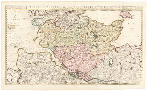
Sold2016Large map of Holstein, Germany 1720Heading: Author: Visscher, Nicolas Title: Holsatiae Ducatus Vernadule das Hertzogtum Holetein... Place Published: Amsterdam Publisher:Pieter Schenk, Jr. Date Published: c.1720 DescriptSee Sold Price
Sold2020Rapkin, John 1860 Lot of 5 British & European MapsIncl Scotland, Germany, England/Wales, Denmark and Northern Italy. Steel Engraved Maps Published 1860 by The London Printing & Published Company, London for "The Royal Dictionary-Cyclopedia for UniverSee Sold Price
21 hrs LeftJasper52PRAETORIAN PREFECTURE OF GAUL. 'Grande Prefecture des Gaules'. MALLET 1683 mapUS$20
21 hrs LeftJasper52L'Allemagne, La Boheme, et La Hongrie; avec…partie de Pologne. BONNE 1780 mapUS$60
3 days LeftAlbion AuctionsNat. Encyclo. 1890's Pair of Celestial Maps. Northern & Southern ConstellationsUS$10(2 bids)
2024Jasper521575 BAVARIA GERMANY MAP LEAF from BELLEFOREST EDITION of MUNSTER COSMOGRAPHYSee Sold Price
21 hrs LeftJasper52German invasion of Belgium and France, May-June 1940. World War 2 1953 old mapUS$30
4 days LeftTrillium Antique Prints & Rare BooksDe Jode, Rare, pub. 1593 - Map of Kingdom of Napoli, Italy (Neapolitani Regni exacta ac diligensUS$130(3 bids)
3 days LeftAlbion AuctionsGentleman's Magazine 1778 Canal Map. Belfast to Loughneagh Northern IrelandUS$5(1 bid)
21 hrs LeftJasper52WORLD WAR 2. English Channel & North sea ports. German occupied Europe 1942 mapUS$30
2 days LeftPotter & Potter AuctionsBOLLMANN, Hermann (1911 – 1971). Map of New York City. 1962.US$100
Featured21 hrs LeftJasper52Europe after the Congress of Vienna. 4 sheets. 128x106cm. THOMSON 1817 old mapUS$550
1 day LeftHermann Historica GmbHA German pair of Victorian miniature cannons in the style of Michel Mann, 19th century€5,000


![1653 Merian Map of Northern Germany -- Meklenburg: Title: 1653 Merian Map of Northern Germany -- Meklenburg Ducatus Cartographer: Merian [family] Year / Place: 1653, Frankfurt Map Dimension (in.): 10.8 X 14.1 in. This is a very handsome map of the his](https://p1.liveauctioneers.com/5584/195879/98794817_1_x.jpg?height=310&quality=70&version=1614724478)


![Jansson (Jan) - [Atlas Novus: Germany],: single vol. lacking title, 106 mostly regional maps of Germany and northern Europe, but also including a general map of Germany, and classical maps of both Germany and Scandinavia, and several city pl](https://p1.liveauctioneers.com/410/80717/41962763_1_x.jpg?height=310&quality=70&version=1445353131)


![[MAP]. ORTELIUS, Abraham. Romani Imperii Imago. 1592. (1 of 2)](https://p1.liveauctioneers.com/197/329395/177650537_1_x.jpg?height=282&quality=70&version=1715364962)
