Sold20241683 Map Of The Great Tartary Northern/Central AsiaBy Giovanni Giacomo and Giovanni Cantelli, Site 18.75" x 23"See Sold Price
Sold2024La Gran Tartaria. Great Tartary. Central/North Asia. ROSSI / CANTELLI 1683 mapTitle: La Gran Tartaria. Great Tartary. Central/North Asia. ROSSI / CANTELLI 1683 map Description: La Gran Tartaria divisa nelle sue parti principali [Great Tartary divided into its main parts] by PubSee Sold Price
Sold2022GREAT TARTARY. 'Grande Tartarie'. Russia China N & Central Asia. MALLET 1683 mapTITLE OF THE MAP: 'Grande Tartarie' (De L'Asie) Tartary (Latin: Tartaria) or Great Tartary (Latin: Tartaria Magna) was a name used by Europeans from the Middle Ages until the twentieth century to desiSee Sold Price
Sold20181732 Moll Map of Tartary and Central Asia -- GreatTitle/Content of Map: 1732 Moll Map of Tartary and Central Asia -- Great Tartary. With the Tract of the Moscovite Ambassador's Travels from Moscow to Pekin in China… Date Printed: 1732, London CartoSee Sold Price
Sold20231730 Bowen Map of China with Marco Polo's Travel Path -- A Map of Marco Polo's Voyages & Travels inTitle: 1730 Bowen Map of China with Marco Polo's Travel Path -- A Map of Marco Polo's Voyages & Travels in the 13th Century Through a Great Part of Asia, All Tartary, the East India Islands & Part ofSee Sold Price
Sold2021Map showing Marco Polo's travelsHeading: Author: Bowen, Emanuel Title: A Map of Marco Polo's Voyages & Travels in the 13th Century Through a Great Part of Asia, All Tartary, the East India Islands & Part of Africa Place Published:See Sold Price
Sold2024CENTRAL ASIA. Tartar warrior & woman. Tents Sword Bow 'Tartarres'. MALLET 1683TITLE OF THE PRINT: 'Tartarres' (De L'Asie) Tartary (Latin: Tartaria) or Great Tartary (Latin: Tartaria Magna) was a name used by Europeans from the Middle Ages until the twentieth century to designatSee Sold Price
Sold2022CENTRAL ASIA. Tartar warrior & woman. Tents Sword Bow 'Tartarres'. MALLET 1683TITLE OF THE PRINT: 'Tartarres' (De L'Asie) Tartary (Latin: Tartaria) or Great Tartary (Latin: Tartaria Magna) was a name used by Europeans from the Middle Ages until the twentieth century to designatSee Sold Price
Sold20211683 Sanson Map Great Lakes to Newfoundland -- LeTitle: 1683 Sanson Map Great Lakes to Newfoundland -- Le Canada, ou Nouvelle France, &c. Tiree de diverses Relations des Francois, Anglois, Hollandois, &c. Cartographer: N Sanson Year / Place: 1683 c.See Sold Price
Sold2017T Cowperthwait: Russia In Asia & Tartary MapRussia in Asia and Tartary, 17 x 13.5 in, 1850, Thomas Cowperthwait Please note that this lot has a confidential reserve. When you leave a bid in advance of the auction, submit your maximum. Jasper52See Sold Price
Sold20181683 Sanson Map of the Great Lakes and the Upper EastTitle/Content of Map: 1683 Sanson Map of the Great Lakes and the Upper East Coast -- Le Canada, ou Nouvelle France, &c. Tiree de diverses Relations des Francois, Anglois, Hollandois, &c. Date: 1683, PSee Sold Price
Sold20181683 Sanson Map of the Great Lakes and the Upper EastTitle/Content of Map: 1683 Sanson Map of the Great Lakes and the Upper East Coast -- Le Canada, ou Nouvelle France, &c. Tiree de diverses Relations des Francois, Anglois, Hollandois, &c. Date Printed:See Sold Price
Sold2022Bellin: Two Maps of Tartary: Northeast & Central AsiaTitle/Content of Map: Bellin: Two Maps of Tartary: Northeast & Central Asia Date Printed: 1749/1760, Paris Cartographer: Bellin Size: 12" x 8 1/2" (each) Bellin's highly detailed maps of Eastern and WSee Sold Price
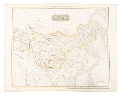
Sold2019Map of Tartary comprising most of AsiaHeading: (Maps) Author: Thomson, John Title: Tartary Place Published: Edinburgh Publisher: Date Published: 1814 Description: Engraved map, hand-colored in outline. 49.8x59.5See Sold Price
Sold2018Mallet, Alain 1683 HC Map of Turkey in Asia, Black Sea"Turquie en Asie" Hand Coloured Copper Engraved Map Published 1683, Paris for "Description de l'Univers" by Alain Manesson Mallet. French text to verso. Paper Size: 8 x 5 inch (20 x 13cm) Good ConditiSee Sold Price
Sold20241851 Tallis Map of Tartary -- Part of Russia in Asia, and Independent TartaryTitle: 1851 Tallis Map of Tartary -- Part of Russia in Asia, and Independent Tartary Cartographer: J Tallis Year / Place: 1851 c., London Map Dimension (in.): 10 X 13 in. This is a rarely seen TallisSee Sold Price
Sold2017Mitchell Cowperthwait: Map of Russia in Asia & TartaryTitle: Map of Russia in Asia and Tartary By Mitchell, Thomas, and Cowperthwait Date: 1851 Dimensions: 17 x 14 Medium: Hand Colored Lithograph Please note that this lot has a confidential reserve. WhenSee Sold Price
Sold20211827 Thomson Map of Asia -- AsiaTitle: 1827 Thomson Map of Asia -- Asia Cartographer: J Thomson Year / Place: 1827, London Map Dimension (in.): 20.2 X 23.6 in. This is an excellent, large, double page map of Asia. The Great Wall ofSee Sold Price
Sold2017Mallet: Antique Map of South Asia, 1683Inde' The map encompasses the whole of India & Indochina including Burma, Thailand, Malaysia/Singapore and South East Asia. The Maldive islands are shown. The map shows the mythical Lake Chiamay, theSee Sold Price
Sold20191870 Knox Voyages to ASIA Siberia China Tartary1870 Knox Voyages to ASIA Siberia China Tartary Illustrated Mongolia MAPS Russia Thomas Wallace Knox was a 19th-century traveler known for his writings on his voyages. This 1871 printing of ‘OverlanSee Sold Price
Sold2020Brockhaus (Pub) 1890's Mixed Lot of 9 MapsIncl West Indies, America Continent, USA, Alexander The Great, Asia, and Middle East. Lithograph Maps 1892-98 by F. A. Brockhaus, Leipzig for "Brockhaus' Konversations-Lexikon" by Various. Centre foldSee Sold Price
Sold2020Ides Travels to China 1706 map & with platesHeading: Author: Ides, Evert Ysbrants Title: Three Years Travels from Moscow Over-land to China: Thro' Great Ustiga, Siriana, Permia, Sibiria, Daour, Great Tartary, &c. to Peking... Place Published:See Sold Price
Sold2017Mitchell: Map of Russia in Asia and Tartary, 1846Map: Russia in Asia and Tartary Publication Date: 1846 Maker: H.N. BURROUGHS, TANNER, HENRY SCHENK/SAMUEL AUGUSTUS MITCHELL Publisher: H.N. BURROUGHS Size: Quarto – 11.25 H x 14.25 W Inches With insSee Sold Price
Sold2023NORTHERN/CENTRAL EUROPE Scandinavia Tribes 'Ancienne Germanie'. MALLET 1683 mapTITLE OF THE MAP: 'Ancienne Germanie' (De L'Europe) Shows Ingaevones istaevones Vindili hermiones Sarmatie Vindelicie DATE PRINTED: 1683 IMAGE SIZE: Approx Overall page size 13 x 21cm approximately (5See Sold Price
Featured6 days LeftJasper521738 RUSSIA SIBERIA & GREAT TARTARY Description illustrated ANTIQUE in ENGLISHUS$950
May 22Jasper52Carte L’Asie. Asia. Mughal Empire. Oirat Kingdom. Tartary. VAUGONDY 1750 mapUS$280
May 22Jasper52La Tartaria Indipendente… Central Asia, Caspian Sea & Caucasus. ZATTA 1785 mapUS$100


![La Gran Tartaria. Great Tartary. Central/North Asia. ROSSI / CANTELLI 1683 map: Title: La Gran Tartaria. Great Tartary. Central/North Asia. ROSSI / CANTELLI 1683 map Description: La Gran Tartaria divisa nelle sue parti principali [Great Tartary divided into its main parts] by Pub](https://p1.liveauctioneers.com/5584/314775/168780611_1_x.jpg?height=310&quality=70&version=1704837726)


![CENTRAL ASIA. Karasm [Khwarezm] Great Bochara [Bukhara] Usbeck Tartary 1746 map (1 of 1)](https://p1.liveauctioneers.com/5584/329387/177649411_1_x.jpg?height=282&quality=70&version=1715717898)


