Sold2020Philipp Cluver "Sicilia Antiqua" 1619Philipp Cluver (1580-1622), "Sicilia Antiqua; cum minoribus insulis, ei adjacentibus. Item, Sardinia et Corsica," 1619. A fine volume on historical Sicily with lovely maps. SKU: 02087See Sold Price
Sold2022Framed Philipp Cluver Map, Denmarkc1600 map showing Denmark and part of Sweden by German geographer Philipp Cluver (1580-1622.) Likely published c.1711. Upper right with "Regi Daniae Accuratissima delineatio" with Mercury and bulls. CSee Sold Price
Sold2022Pair hand-colored antique maps, 17th c.Pair hand-colored antique maps, 17th c., Philipp Cluver (German, 1580-1622), "Viro Antiqua domo Generoso ac Nobili: Omni Virtute pollenti...", engraving of Ancient Italy on laid paper, as two sheets jSee Sold Price
Sold2020Herman Moll Emanuel Bowen "A Complete System of GHerman Moll (ca. 1654-1732) and Emanuel Bowen (1694-1767), "A Complete System of Geography," London, 1747. Volumes I and II. The title page reads: "A Complete System of Geography. Being a DescriptionSee Sold Price
Sold2020Herman Moll Map of Africa ca. 1720Herman Moll (ca. 1654-1732). Map of Africa, London, ca. 1720. With an elaborate dedication cartouche reading "To the right honourable Charles, Earl of Peterborow and Monmouth, etc this map of Africa aSee Sold Price
Sold2020Grp: 5 Maps of Germany Europe and the MediterraneGroup of five 18th century maps. This group includes a hand colored map of Germany by Herman Moll (ca. 1654-1732); one map of the Turkish empire by Tobias Conrad Lotter (1717-1777); one map of the BriSee Sold Price
Sold2017Moll - Correct Map of the Whole World, 1719Herman Moll (1654?-1732), cartographer and publisher A New & Correct Map of the Whole World Shewing y.e Situation of its Principal Parts. Viz the Oceans, Kingdoms, Rivers, Capes, Ports, Mountains, WooSee Sold Price
Sold2019Herman Moll 1654-1732), "A New And Correct Map of theHerman Moll 1654-1732), "A New And Correct Map of the World," 1710, hand colored, H. - 22 in., W. - 38 in.See Sold Price
Sold20231729 Map of New England, New York, Herman Moll1729 English Map of New England, Herman Moll (1654-1732). Map titled, "NEW ENGLAND NEW YORK NEW JERSEY and PENNSYLVANIA". Map with detailed depiction of the North East, with hand coloring. Good conditSee Sold Price
Sold2016America by Herman Moll 1716Map Title: America, According to the Newest and Most Exact Observations Maker: Herman Moll Date: 1716 Origin: Atlas Geographicus Size: 13 x 16 inches Medium: Copperplate engraving Herman Moll (1654-17See Sold Price
Sold2016Carolina & Bermuda 1716Map Title: Carolina & The Island Bermudos Maker: Herman Moll Date: 1716 Origin: Atlas Geographicus Size: 13 x 16 inches Medium: Copperplate engraving Herman Moll (1654-1732) was a London cartographer,See Sold Price
Sold2024Herman Moll A New Map of Ye North Parts of AmericaHerman Moll (British, 1654-1732). Colored engraved map, A New Map of Ye North Parts of America Claimed by France Under Ye Names of Louisiana, Mississipi [sic], Canada & New France, With the AdjoiningSee Sold Price
Sold2023HERMAN MOLL (ENGLISH, C. 1654-1732) MAP OF NORTH AND SOUTH CAROLINAHERMAN MOLL (ENGLISH, C. 1654-1732) MAP OF NORTH AND SOUTH CAROLINA, hand-colored engraving on laid paper, titled "CAROLINA / By / H. Moll Geographer" in a rectangular cartouche along lSee Sold Price
Sold2022Herman Moll's New Map of the World - California as an Island!, Ca. 1725Herman Moll's New Map of the World - California as an Island!, Ca. 1725 1p, measuring 13.625" x 8.5", n.p., ca. 1725. A hand-colored map entitled "A New Map of the World according to the New ObservatiSee Sold Price
Sold2020Philipp Cluver map- LithuaniaPhilipp Cluver- ''Lithuania''- hand-colored copper engraving from the atlas- ''Introductionis in Universam Geogruphiam'', ca. 1676. 7 5/8 x 10 1/2''See Sold Price
Sold2022MOLL, HERMAN. A New Map of the North Parts of America claimed by France under ye Names of Louisiana,MOLL, HERMAN. A New Map of the North Parts of America claimed by France under ye Names of Louisiana, Mississipi, Canada and New France with ye Adjoyning Territories of England and Spain. Large engraveSee Sold Price
Sold2022MOLL, HERMAN. [The World Described].MOLL, HERMAN. [The World Described]. 18 engraved multiple-sheet folding maps with original outline hand-color (i.e., incomplete; no beaver map, no codfish map). Tall folio, 25x12 inches, period calf bSee Sold Price
Sold2022HIGHLY IMPORTANT RENAISSANCE CAMEO, PEARL ENAMEL AND DIAMOND PENDANTHIGHLY IMPORTANT RENAISSANCE CAMEO, PEARL, RUBY DIAMOND AND ENAMEL PENDANT, ca. 1580. Set to the center with a carved cameo, surrounded with pearls and rubies. The openwork scrolling pendant decoratedSee Sold Price
Sold2022HIGHLY IMPORTANT RENAISSANCE CAMEO, PEARL ENAMEL AND DIAMOND PENDANTHIGHLY IMPORTANT RENAISSANCE CAMEO, PEARL, RUBY DIAMOND AND ENAMEL PENDANT, ca. 1580. Set to the center with a carved cameo, surrounded with pearls and rubies. The openwork scrolling pendant decoratedSee Sold Price
Sold2021Painting, Attributed to Lorenzo GarbieriAttributed to Lorenzo Garbieri (Italian, 1580-1654), "Saint Sebastian Tended by Saint Irene," oil on panel, unsigned, partial artist label affixed verso, British wax seal with crest verso, panel (unfrSee Sold Price
Sold2022BEAVER MAP, HERMAN MOLL (DUTCH/BRITISH, 1654-1732)A New and Exact Map of the Dominions of the King of Great Britain on ye Continent of North America containing Newfoundland, New Scotland, New England, New York, New Jersey, Pensilvania, Maryland, VirgSee Sold Price
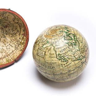
Sold2023(GLOBES.) Style of Herman Moll. A Correct Globe with the New Discoveries.(GLOBES.) Style of Herman Moll. A Correct Globe with the New Discoveries. 2¾-inch miniature terrestrial pocket globe comprised of 12 hand-colored engraved gores and 2 polar calottes on a plasterSee Sold Price
Sold2024Map of the North Parts of America Claimed by France by Herman Moll (London, 1720)Map of the North Parts of America Claimed by France by Herman Moll (London, 1720) "A New Map of the North Parts of America claimed by France under ye Names of Louisiana, Mississippi, Canada, and New FSee Sold Price
Sold2017FRAMED WORLD MAP BY HERMAN MOLL, 1719'A New & Correct Map of the Whole World, by Herman Moll, Geographer, 1719.' Hand tinted and framed. Frame size: 73 x 124 cm (28 3/4 x 48 3/4 in.)See Sold Price
4 days LeftUniversity ArchivesAuthentic Atocha Recovered Silver Coin, With A Wonderful Strike And Patina!US$600(6 bids)
7 days LeftTrillium Antique Prints & Rare BooksHarris - Chart of the Atlantic Ocean with part of the Americas, Europe, AfricaUS$75
7 days LeftTrillium Antique Prints & Rare BooksHarris - Map of India and East Indies Islands (Part of China & East Asia)US$75
5 days LeftWestmore Galleries and Auctions1585 OXONIUM VINDESORIUM (OXFORD AND WINDSOR CASTLE) BY BRAUN AND HOGENBERG, FRAMEDUS$300
Jul 16BADO e MART AUCTIONSDiploma of Nobility on Parchment. LOUIS XIV. Diploma of Nobility for Jean Jouenne, Lord of la€600
4 days LeftUniversity ArchivesAlbert Einstein’s Theory of Relativity: First Hebrew Edition!US$200(1 bid)
BonhamsGiovanni Battista Piranesi (Italian, 1720-1778) The Forum of Augustus Etching, 1757, on heavy la...£500
Jul 09Hermann Historica GmbHEmil Rumpf (1860 - 1948) - sketches and graphic sheets, mostly 19th century€400
4 days LeftPotter & Potter Auctions[ARTIST UNKNOWN] 14 Western Cowboy Portrait Photos [Ca. 197...US$200
1 day LeftCurated Gallery AuctionsRobert Philipp 1895-1981 Antique American Impressionist Central Park Portrait Original Oil PaintingUS$100(4 bids)
Jul 07Case Antiques, Inc. Auctions & AppraisalsEames Black Lounge Chair & Ottoman by Herman Miller, Set 2 of 2US$1,100(2 bids)
Jul 06Case Antiques, Inc. Auctions & AppraisalsEames Chair & Ottoman, Brown Leather, Herman MillerUS$1,000(1 bid)
Jul 06Case Antiques, Inc. Auctions & AppraisalsEames Black Lounge Chair and Ottoman by Herman Miller, Set 1 of 2US$1,000(1 bid)


![Herman Moll A New Map of Ye North Parts of America: Herman Moll (British, 1654-1732). Colored engraved map, A New Map of Ye North Parts of America Claimed by France Under Ye Names of Louisiana, Mississipi [sic], Canada & New France, With the Adjoining](https://p1.liveauctioneers.com/7691/320359/172153415_1_x.jpg?height=310&quality=70&version=1708543789)


![MOLL, HERMAN. [The World Described].: MOLL, HERMAN. [The World Described]. 18 engraved multiple-sheet folding maps with original outline hand-color (i.e., incomplete; no beaver map, no codfish map). Tall folio, 25x12 inches, period calf b](https://p1.liveauctioneers.com/199/251723/130782476_1_x.jpg?height=310&quality=70&version=1655133895)


![[Literature] Pope, Alexander: Autograph Letter, signed (1 of 2)](https://p1.liveauctioneers.com/65/332523/179335149_1_x.jpg?height=282&quality=70&version=1717709446)


![[ARTIST UNKNOWN] 14 Western Cowboy Portrait Photos [Ca. 197... (1 of 15)](https://p1.liveauctioneers.com/928/330686/178766023_1_x.jpg?height=282&quality=70&version=1716992685)


