Sold20211823 Gazetteer New Hampshire INDIANS Slavery Map1823 Gazetteer New Hampshire INDIANS Slavery Map Early AMERICA Americana “A Gazetteer of the State of New-Hampshire” is a general view of 19th-century New Hampshire. Authors Moore and Farmer incluSee Sold Price
Sold20211823 GAZETTEER of NEW HAMPSHIRE by J.FARMER & J.MOOREGazetteer of the State of New Hampshire Embellished with an Accurate Map of the State, and Several Other Engravings by Abel Bowen Concord, Published by Jacob B. Moore; 1823 Size 4 3/4 by 7 1/4" 276 paSee Sold Price
Sold20231813 1ed New York Gazetteer SLAVERY Horatio Spafford Geography MAP Americana1813 1ed New York Gazetteer SLAVERY Horatio Spafford Geography MAP Americana Horatio Gates Spafford was a late 18th century historian. Not to be confused with his son, the esteemed American hymn writeSee Sold Price
Sold20201813 1ed New York Gazetteer SLAVERY Horatio Spafford1813 1ed New York Gazetteer SLAVERY Horatio Spafford Geography MAP Americana Horatio Gates Spafford was a late 18th century historian. Not to be confused with his son, the esteemed American hymn writeSee Sold Price
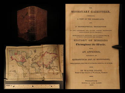
Sold20211825 1ed Missionary Gazetteer Chapin Slavery Indians1825 1ed Missionary Gazetteer Chapin Slavery Indians Illustrated Color World MAP ‘Missionary Gazetteer’ is a general history of missions throughout the world arranged alphabetically with an appendSee Sold Price
Sold2024Lot of 3 small maps from Scott's Gazeteer "Vermont, New Hampshire and N.W. Territories"Scott's Gazetteer, published in 1795 by Joseph Scott, is considered the first gazetteer of the United States. It's a comprehensive reference book offering detailed descriptions of the various states iSee Sold Price
Sold20221824 New York Gazetteer SLAVERY Horatio Spafford Geography Americana Indians1824 New York Gazetteer SLAVERY Horatio Spafford Geography Americana Indians Horatio Gates Spafford was a late 18th century historian. Not to be confused with his son, the esteemed American hymn writeSee Sold Price
Sold20231897 1ed Alaska & Klondike Gold Mining Fields Canada Eskimo INDIANS Slavery MAP1897 1ed Alaska & Klondike Gold Mining Fields Canada Eskimo INDIANS Slavery MAP AC Harriss “Alaska and the Klondike Gold Fields” is a 19th-century account of expeditions in Canada and AlasSee Sold Price
Sold20231897 1ed Alaska & Klondike Gold Mining Fields Canada Eskimo INDIANS Slavery MAP1897 1ed Alaska & Klondike Gold Mining Fields Canada Eskimo INDIANS Slavery MAP AC Harriss “Alaska and the Klondike Gold Fields” is a 19th-century account of expeditions in Canada and AlasSee Sold Price
Sold20191857 New Hampshire INDIAN Illustrated WITCH TRIALS Revo1857 New Hampshire INDIAN Illustrated WITCH TRIALS Revolutionary WAR Americana ‘New Hampshire As It Is’ is a 19th-century survey on New Hampshire from Edwin Charlton. Charlton pulled from a varietSee Sold Price
Sold20201857 New Hampshire, INDIAN, WITCH, Revolutionary 1st ed1857 New Hampshire, INDIAN, WITCH TRIALS, Revolutionary WAR Americana, first edition New Hampshire As It Is Illustrated This is a 19th-century survey on New Hampshire from Edwin Charlton. Charlton pulSee Sold Price
Sold20211862 Nashua New Hampshire Indian Head Bank Paper1862 Nashua New Hampshire Indian Head Bank Paper Quarter. Used heavily during the Civil War. FineSee Sold Price
Sold20231897 1ed Alaska & Klondike Gold Fields Canada INDIANS Cannibalism Slavery MAP1897 1ed Alaska & Klondike Gold Fields Canada INDIANS Cannibalism Slavery MAP AC Harriss “Alaska and the Klondike Gold Fields” is a 19th-century account of expeditions in Canada and AlaskaSee Sold Price
Sold20181784 1st ed History of New Hampshire Belknap INDIANS1784 1st ed History of New Hampshire Belknap INDIANS Revolutionary WAR Americana The first extensive history of New Hampshire! Jeremy Belknap was an 18th-century American historian from New HampshireSee Sold Price
Sold20231890s Map of Vermont and New Hampshire -- County Map of Vermont and New HampshireTitle: 1890s Map of Vermont and New Hampshire -- County Map of Vermont and New Hampshire Cartographer: Anonymous Year / Place: 1890 ca. Map Dimension (in.): 21.6 X 14.8 in. This is an outstanding doubSee Sold Price
Sold20231860 Grafton County New Hampshire Topographic MapImmerse yourself in the rich history of Grafton County, New Hampshire, with this captivating Framed Topography Map from 1860. This vintage map offers a glimpse into the past, showcasing the intricateSee Sold Price
Sold2017Mitchell: New Hampshire & Vermont Map, 1877New Hampshire and Vermont, 15 x 22.75 in, 1877, S. Augustus Mitchell Please note that this lot has a confidential reserve. When you leave a bid in advance of the auction, submit your maximum. Jasper52See Sold Price
Sold2022Two New Hampshire Wall Maps.Belknap County, Smith and Peavy, 1860, 53 x 56 inches. Rockingham County, Smith and Coffin, 1857, 56 x 59 inches. Both in poor condition.See Sold Price
Sold2016[Manuscript map] PLAN OF BRADFORD. 1844.[New Hampshire/Manuscript Map] PLAN OF BRADFORD. Manuscript plat map showing the various plots of land in Bradford, a post-township in Hillsborough Co., New Hampshire. Each plot is labeled with the naSee Sold Price
Sold20211884 New Hampshire and Vermont MapTitle: 1884 New Hampshire and Vermont Map Author: Cram Medium: Ink on Paper Dimensions: 11"X13.5" Description: Map of New Hamsphire and Vermont dated 1885. Printed and published by George Cram in ChicSee Sold Price
Sold2020BELKNAP, JEREMY. The History of New Hampshire.BELKNAP, JEREMY. The History of New Hampshire. Engraved folding map. 3 volumes. 8vo, 8¼x5¼ inches, modern quarter calf; some staining, map heavily offset and with closed splits along fold liSee Sold Price
Sold20191851 Gavit / Romans Map First Showing Vermont, and alsoTitle/Content of Map: 1851 Gavit / Romans Map First Showing Vermont, and also New York and New Hampshire -- A Chorographical Map of the Northern Department of North America, Drawn from the Latest andSee Sold Price
Sold2017Bradford: Antique Map of New Hampshire, 1838Title/Content of Map: New Hampshire by Bradford Date Printed: 1838/1841 Cartographer: Thomas G. Bradford Material/Medium: Paper Size: 13" x 16 1/2" Hand colored. A General Atlas of the World with a SeSee Sold Price
Sold2020New Hampshire & Vermont, 1845Title/Content of Map: New Hampshire & Vermont, 1845 Date Printed: 1845, Hildburghausen Cartographer: Joseph Meyer/Bibliographisches Instituts. Size: 11 3/4" x 14 3/4" The beautifully detailed and coloSee Sold Price
2 days LeftJasper521890s Cram Map of Vermont [verso] New Hampshire -- Vermont [verso] New HampshireUS$30
May 30Forum AuctionsChina.- Gazetteer of Places Names (A) in Hong Kong, Kowloon and the New Territories, Hong Kong, W.£400
1 day LeftFleischer's Auctions1755 Map Partie de l'Amerique Septentrionale, qui comprend Le Cours de L'Ohio...US$200(3 bids)
4 days LeftFreeman's | HindmanWilliam Zorach (American, 1887-1966) Waterfall, Randolph, New Hampshire, 1915US$4,500(4 bids)
May 25Eagles Corps International LLC12TH New Hampshire Civil War Veterans Cast Iron MusketUS$5(1 bid)
BonhamsWalker Evans (1903-1975); Three Photographs including: Bedroom Interior, Enfield, New Hampshire;...US$500(1 bid)
7 days LeftFontaine's Auction GalleryAttributed to George Loring Brown (American, 1814-1889), Mount Chocorua, New HampshireUS$300
May 25Eagles Corps International LLC(16) Civil War New Hampshire Veterans Medals and RibbonsUS$17(3 bids)
May 24Meander Auctions by Andrew Richmond and Hollie DavisNEW HAMPSHIRE SCHOOLGIRL SAMPLERUS$150(1 bid)
May 24Eldred'sGEORGE MCCONNELL (Maine/Ohio, 1852-1929), Eagle Cliff, Franconia Notch, New Hampshire., Oil onUS$250
7 days LeftBroward Auction GalleryElizabeth Horning (AZ,NH,MA,b 1943) watercolor paintingUS$80(3 bids)


![[Manuscript map] PLAN OF BRADFORD. 1844.: [New Hampshire/Manuscript Map] PLAN OF BRADFORD. Manuscript plat map showing the various plots of land in Bradford, a post-township in Hillsborough Co., New Hampshire. Each plot is labeled with the na](https://p1.liveauctioneers.com/179/93063/47518624_1_x.jpg?height=310&quality=70&version=1472482862)


![1890s Cram Map of Vermont [verso] New Hampshire -- Vermont [verso] New Hampshire (1 of 2)](https://p1.liveauctioneers.com/5584/328338/176911596_1_x.jpg?height=282&quality=70&version=1715113718)


