Sold20191823 Lucas Handcolored Map Orbis Veteribus NotusMap of the Ancient world entitled “Orbis Veteribus Notus”, engraved at Baltimore by E. Lucas, Jr. 1823. Hand coloring, Fine condition, measures 14.5 x 11.5”. Reserve: $20.00 Shipping: Domestic:See Sold Price
Sold20221763 d'Anville Ancient World Map -- Orbis Veteribus Notus Auspiciis Serenissimi Principis LudoviciTitle: 1763 d'Anville Ancient World Map -- Orbis Veteribus Notus Auspiciis Serenissimi Principis Ludovici Philippi Aurelianorum Ducis Publici Juris Factus Cartographer: J d'Anville Year / Place: 1763,See Sold Price
Sold20191763 d'Anville Ancient World Map -- Orbis VeteribusTitle/Content of Map: 1763 d'Anville Ancient World Map -- Orbis Veteribus Notus Auspiciis Serenissimi Principis Ludovici Philippi Aurelianorum Ducis Publici Juris Factus Date: 1763, London CartographeSee Sold Price
Sold20221763 LUDOVICI PHILIPPI MAP18th century original map of Europe titled ORBIS VETERIBUS NOTUS by Ludovici Philippi dated 1763. Auetor D'Anville. VG condition, no stains or tears. 21 x 29, framed 23 x 31 inches.See Sold Price
Sold20201823 Lucas Map of Africa -- AfricaTitle/Content of Map: 1823 Lucas Map of Africa -- Africa Cartographer: F Lucas Year/Place: 1823, Baltimore Size: 10.6 X 8.7 in. This is an excellent map of Africa, with inset of Azores and Cape Verd.See Sold Price
Sold20231763 Orbis Veteribus Nobis -Santini1763 Santini - Orbis Veteribus Nobis - Mediterrian Map 24 x 32" as framed.See Sold Price
Sold2023Biritsh Islands, Four Antique MapsDescription: A group of maps of the British Islands, including an 1840 Jeremiah Greenleaf map of the British Islands, an 1823 map of Ireland by Fielding Lucas, and 1823 map of England and Wales by FieSee Sold Price
Sold2017Reimer/Kiepert: Antique Map of the Ancient World, 1863Map Ancient World. 'orbis Terrarum Antiquis Notus', 1863 D Reimer / H Kiepert. Berlin. 18 x 14 inches. 1863. Signed Please note that this lot has a confidential reserve. When you leave a bid in advancSee Sold Price
Sold2019Nicolao Visscher. Orbis Terrum Nova MapNicolao Visscher (Dutch, 1618-1709). A hand-colored engraved map, circa 1658. Orbis Terrum Nova et Accuratussna Tabula. Showing partial coastlines of New Zealand and Australia. Unframed. 23-1/2 in x 2See Sold Price
Sold2018Johannes Blaeau (1650-1712, Dutch), "Nicaea ad VarumJohannes Blaeau (1650-1712, Dutch), "Nicaea ad Varum Cum Novo Orbis," 17th c., hand colored map, framed, H.- 23 1/2 in., W.- 28 1/2 in.See Sold Price
Sold2022AN AMERICAN CIVIL WAR ERA MAP, "United States of North America (Eastern & Central)," LONDON,AN AMERICAN CIVIL WAR ERA MAP, "United States of North America (Eastern & Central)," LONDON, 1861-1873, THEODORE ETTLING (b. 1823), hand colored lithograph on paper, by T. Ettling, published by CasselSee Sold Price
2022Blaeu, Johannes (Netherlands, 1596-1673) "The New World Map" Double Hemisphere World Map C. 1664Nova et Accuratissima Totius Terrarum Orbis Tabula Translated "The New World Map", Hand Colored w/ Elaborately Decorated Spandrels.   Sight View 16" x 21-1/2", Overall View 21" x 25-1/2"See Sold Price
Sold2020Ortelius Map of Africa 1570Abraham Ortelius (1527-1598), "Africae Tabula Nova," Antwerp, 1570. This hand colored map of Africa originates from Ortelius' "Theatrum Orbis Terrarum." The map shows political divisions within AfricaSee Sold Price
Sold2024Nicolaes Van Geelkercken, 1632 world mapNicolaes Van Geelkercken, 1632 world map, Orbis Terrarum Descriptio Duobis Planis Hemisphaeriis Comprehesa, hand-colored engraving, 20th c. restrike, matted and framed under glass, 17"h x 23"w (sight)See Sold Price
Sold2024Very Rare Mexico Nova Hispania 1579 Hand Colored MapORTELIUS, Abraham (1527-1598). Theatrum Orbis Terrarum. 1570. It is considered to be the first modern atlas. Map of New Spain (Mexico), 1579. Printed in Antwerp by Christophe Plantin (1588). Etching.See Sold Price
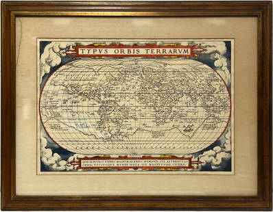
2023Early World Map "Typvs Orbis Terrarvm" Hand ColorDated 1590 near bottom legend box. Hand colored, with red and orange watercolor prominent in the titles. Blue clouds in border. Some slight use of yellow in the boundaries of the map. With signature oSee Sold Price
Sold2018Map Matth Seutter 1730 Novus Orbis Sive AmericaMap Matth Seutter (1676-1757). Copper engraving hand colored, map measures approximately 24" L x 20.25" H w/frame approximately 27" W x 23.5" H. Condition: Good, some foxing and center fold mark. NovuSee Sold Price
Sold2018Hand Colored Map of the World, Willem BlaeuWillem Blaeu, (Dutch, 1571-1638) "Nova Totius Terrarum Orbis Geograhica ac Hydrographica" originally published 1606 Nice old color example of Blaeu's classic world map Approx. 19.5" x 25.5" (unframed)See Sold Price
Sold2019Gilles Robert de Vaugondy (1688-1766), "Orbis Vetus inGilles Robert de Vaugondy (1688-1766), "Orbis Vetus in Utraque Continente Juxta Mentem Sansoniam·distinctus, Redactus," 1752, Hemisphere map, hand colored, H.- 20 in., W.- 30 in.See Sold Price
Sold2015Prints, Old Master Maps and Allegorical Scenes(Lot of 8) Old Master etchings and engravings of maps and allegorical scenes including; Ptolemy, "Title Page," from Claudii Ptolemaei tabulas Geographicas Orbis Terarum Veteribus Cogniti, 1704; CloppeSee Sold Price
Sold2015Pair of Henry Fisher, Hand Colored MapsPublished by Henry Fisher, Caxton London. Each hand colored, one depicting British Dominions m North America, with date of 1823, and the other depicting North America with date of 1825. Each matted anSee Sold Price
Sold2018Antique Hand Colored Maps of The AmericasAntique Hand Colored Maps of The Americas. This lot features two 19th century hand colored maps of North America and South America from the Carey and Lee Atlas American Edition 1823-24. Both maps areSee Sold Price
Sold2024Gerard Mercator (Belgian 1512 - 1594) and Rumold Mercator (Belgian 1545 - 1599)Gerard Mercator (Belgian 1512 - 1594) and Rumold Mercator (Belgian 1545 - 1599) "Orbis Terrae Compendiosa Descriptio", circa 1595 Engraved and hand colored map 14 1/2" x 19 3/4" Condition: aging, yellSee Sold Price
10 hrs LeftJasper521823 MAP of WINDWARD ISLAND GEOGRAPHICAL STATISTICAL HISTORICAL antique 17.5x 22US$75
May 09Hunt and Peck Estate Services, Inc.Abraham Ortelius map of Bitiurigum from Theatrum Orbis TerrarumUS$50
4 days LeftTrillium Antique Prints & Rare BooksDe Jode, Rare, pub. 1593 - Map of Part of Germany (Sveviae Utriusq cum Germicae tum RheticaeUS$100
4 days LeftTrillium Antique Prints & Rare BooksDe Jode, Rare, pub. 1593 - Map of Austria (Austriae Ducatus Seu Pannoniae Superioris?)US$100
4 days LeftTrillium Antique Prints & Rare BooksBraun & Hogenberg, pub. 1575 - View of Cusco, Peru and MexicoUS$100(1 bid)
4 days LeftTrillium Antique Prints & Rare BooksBraun & Hogenberg, pub. 1575 - View of Jerusalem, IsraelUS$100(1 bid)
4 days LeftTrillium Antique Prints & Rare BooksBraun & Hogenberg, pub. 1575 - View of Ghent, BelgiumUS$100
May 09Hunt and Peck Estate Services, Inc.Abraham Ortelius Natoliae, Quae Olim Asia Minor, Nova DescriptioUS$100
4 days LeftTrillium Antique Prints & Rare BooksBraun & Hogenberg, pub. 1575 - View of Rotterdam, NetherlandsUS$100
4 days LeftTrillium Antique Prints & Rare BooksBraun & Hogenberg, pub. 1575 - View of Innsbruck, GermanyUS$100
4 days LeftTrillium Antique Prints & Rare BooksBraun & Hogenberg, pub. 1575 - View of LuxembourgUS$100
4 days LeftTrillium Antique Prints & Rare BooksCarey & Lea's .. American Atlas - Volume with 46 Originally Hand-colored Folio MapsUS$1,000(1 bid)


![[MAP - TOURS] (1 of 1)](https://p1.liveauctioneers.com/292/326828/175962850_1_x.jpg?height=282&quality=70&version=1713473479)

