Sold20221763 d'Anville Ancient World Map -- Orbis Veteribus Notus Auspiciis Serenissimi Principis LudoviciTitle: 1763 d'Anville Ancient World Map -- Orbis Veteribus Notus Auspiciis Serenissimi Principis Ludovici Philippi Aurelianorum Ducis Publici Juris Factus Cartographer: J d'Anville Year / Place: 1763,See Sold Price
Sold20191823 Lucas Handcolored Map Orbis Veteribus NotusMap of the Ancient world entitled “Orbis Veteribus Notus”, engraved at Baltimore by E. Lucas, Jr. 1823. Hand coloring, Fine condition, measures 14.5 x 11.5”. Reserve: $20.00 Shipping: Domestic:See Sold Price
Sold20191763 d'Anville Ancient World Map -- Orbis VeteribusTitle/Content of Map: 1763 d'Anville Ancient World Map -- Orbis Veteribus Notus Auspiciis Serenissimi Principis Ludovici Philippi Aurelianorum Ducis Publici Juris Factus Date: 1763, London CartographeSee Sold Price
Sold20221763 LUDOVICI PHILIPPI MAP18th century original map of Europe titled ORBIS VETERIBUS NOTUS by Ludovici Philippi dated 1763. Auetor D'Anville. VG condition, no stains or tears. 21 x 29, framed 23 x 31 inches.See Sold Price
Sold20231763 Orbis Veteribus Nobis -Santini1763 Santini - Orbis Veteribus Nobis - Mediterrian Map 24 x 32" as framed.See Sold Price
Sold2017Reimer/Kiepert: Antique Map of the Ancient World, 1863Map Ancient World. 'orbis Terrarum Antiquis Notus', 1863 D Reimer / H Kiepert. Berlin. 18 x 14 inches. 1863. Signed Please note that this lot has a confidential reserve. When you leave a bid in advancSee Sold Price
Sold2015Prints, Old Master Maps and Allegorical Scenes(Lot of 8) Old Master etchings and engravings of maps and allegorical scenes including; Ptolemy, "Title Page," from Claudii Ptolemaei tabulas Geographicas Orbis Terarum Veteribus Cogniti, 1704; CloppeSee Sold Price
Sold2020Framed Antique Map Orbis Vetus, Robert De VaugondyItem/Description: Old print. Map of the world by Robert de Vaugondy from 1752. Orbis vetus in utraque continente : In both the old continent / world map / Vaugondy 1752. Material: Print framed under gSee Sold Price
Sold2023Mercator, Rumold (1545-1599) World MapAn engraved double-page double hemispheric world map, "Orbis Terrae Compendiosa Descriptio". Dimensions:Sight is 11 1/4" x 20 3/4", the frame 21" x 29 1/2". Provenance:From a Philadelphia Collection.See Sold Price
Sold2024Nicolaes Van Geelkercken, 1632 world mapNicolaes Van Geelkercken, 1632 world map, Orbis Terrarum Descriptio Duobis Planis Hemisphaeriis Comprehesa, hand-colored engraving, 20th c. restrike, matted and framed under glass, 17"h x 23"w (sight)See Sold Price
Sold2017Sanson: Antique Map of the Ancient World, 1679Map: Orbis Vetus, et Orbis Veteris Utraque Continens, Terrarumque Tractus Arcticus et Antarctibus Cartographer: Nicholas Sanson Place & Date: Paris / 1679 Size: 21 1/4" x 15" Condition: outline color;See Sold Price
Sold2022Ortelius 16th Cent. ''Americae Siv Novi Orbis' MapAbraham Ortelius 16th Cent. ''Americae Siv Novi Orbis Nova Descriptio'' Map Engraving. Hand tinted Western Hemisphere map of America circa 1570-73, printed in Antwerp. Gallery framed with glass on botSee Sold Price
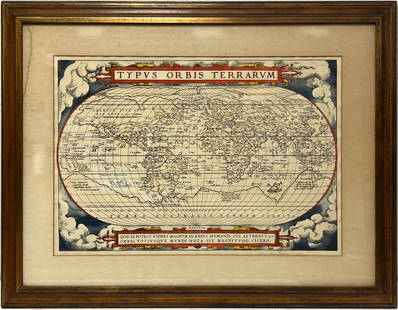
2023Early World Map "Typvs Orbis Terrarvm" Hand ColorDated 1590 near bottom legend box. Hand colored, with red and orange watercolor prominent in the titles. Blue clouds in border. Some slight use of yellow in the boundaries of the map. With signature oSee Sold Price
Sold2023seutter Map, Novus Orbis sive AmericaSEUTTER, Georg Matthaus (1678-1757). Novus Orbis sive America Meridionalis et Septentrionalis... Engraved map with original hand color. Nuremberg, c. 1740. 19 5/8" x 22 3/4" sheet. This striking map oSee Sold Price
Sold2017Launay World Map - Typus Orbis Terrarum, 1720Map: Launay World Map - Typus Orbis Terrarum Cartographer: C. Launay Date: ca. 1720 Size: 5 x 8 inches A quite rare, unique and charming double hemisphere map showing very rough approximations for theSee Sold Price
Sold2016Seutter, Matthaeus, 1678-1756, 1744 Map: "Novus OrbisSeutter, Matthaeus, 1678-1756, 1744 Map: "Novus Orbis Sive America Meridionalis Et Septentrionalis : divisa per sua regna, provincias et insul: cura et opera. Matth. Seutt. S.C.M. Geogr. Aug. Vind.,,,See Sold Price
2017America Sive Nuvi Orbis MapAmerica Sive Nuvi Orbis. 22 x 17 in. Reproduction. Please note that this lot has a reserve. When you leave a bid in advance of the auction, submit your maximum. Jasper52 will bid on your behalf as mucSee Sold Price
Sold2021Map, ""Typus Orbis Terrarum", by Abraham OrteliusMap, ""Typus Orbis Terrarum", by Abraham Ortelius, plate size is 14" by 19.5", edition, age unknown, good conditionSee Sold Price
Sold2017Moxon: Geo-religious Map of the Ancient World, 1671Map: Totius Orbis Terrarum Tabula, Eiusque Post Diluvium Divisio Inter Filios Noachi Cartographer: J. Moxon Place & Date: London / 1671 Size: 13" x 8" Condition: outline color; overall age toning A faSee Sold Price
Sold2016[World Map]. Rumold Mercator. Orbis terrae compe[World Map]. Rumold Mercator. Orbis terrae compendiosa descriptio.&See Sold Price
Sold2017After Van Geelkercken, Orbis Terrarum MapAfter Nicholas (Nicolaes) van Geelkercken (Netherlandish, circa 1585-1656), "Orbis Terrarum Descriptio Duobis Planis Hemisphaeriis Comprehesa", hand colored world map on paper. Hand colored engravingSee Sold Price
Sold2019Nicolao Visscher. Orbis Terrum Nova MapNicolao Visscher (Dutch, 1618-1709). A hand-colored engraved map, circa 1658. Orbis Terrum Nova et Accuratussna Tabula. Showing partial coastlines of New Zealand and Australia. Unframed. 23-1/2 in x 2See Sold Price
Jun 07Freeman's | Hindman[MAP]. ORTELIUS, Abraham. Americae Sive Novi Orbis, Nova Descriptio. 1573.US$1,000(1 bid)
Jun 07Freeman's | Hindman[MAP]. TODESCHI, Pietro. [Nova et Acurata Totius Americae Tabula auct. G.I. Blaeu] America quartaUS$5,000
5 days LeftTrillium Antique Prints & Rare BooksDe Jode, Rare, pub. 1593 - Map of Kingdom of Napoli, Italy (Neapolitani Regni exacta ac diligensUS$130(3 bids)
5 days LeftTrillium Antique Prints & Rare BooksDe Jode, Rare, pub. 1593 - Map of the Holy Land (Descriptio Et Situs Terrae Sanctae Alio NomineUS$100(1 bid)
5 days LeftTrillium Antique Prints & Rare BooksDe Jode, Rare, pub. 1593 - Map of Hainut, Belgium (Hannoniae Comitatus Descriptio)US$100(1 bid)
May 30NY Elizabeth ANTIQUE GEOMORPHOLOGY: 1782 POMPONII MELA DE SITU ORBIS ARMORIAL VELLUM BINDINGUS$50
5 days LeftTrillium Antique Prints & Rare BooksBraun & Hogenberg, pub. 1575 - View of Chios, GreeceUS$120(2 bids)
5 days LeftTrillium Antique Prints & Rare BooksBraun & Hogenberg, pub. 1575 - Views of Copenhagen, DenmarkUS$100
5 days LeftTrillium Antique Prints & Rare BooksBraun & Hogenberg, pub. 1575 - Lower View of Rome, ItalyUS$100
5 days LeftTrillium Antique Prints & Rare BooksBraun & Hogenberg, pub. 1575 - View of Dordrecht, NetherlandsUS$100
5 days LeftTrillium Antique Prints & Rare BooksBraun & Hogenberg, pub. 1575 - View of Granata (Granada), SpainUS$100
5 days LeftTrillium Antique Prints & Rare BooksBraun & Hogenberg, pub. 1575 - View of Perugia, ItalyUS$100
5 days LeftTrillium Antique Prints & Rare BooksAudubon, Amsterdam Edition - Large-billed Puffin. 293US$100
5 days LeftTrillium Antique Prints & Rare BooksAudubon, Amsterdam Edition - Common Merganser. 331US$100
1 day LeftFleischer's Auctions1755 Map Partie de l'Amerique Septentrionale, qui comprend Le Cours de L'Ohio...US$200(3 bids)
6 days LeftBlackstone Valley Auctions & Estates LLCRevolutionary Era War Map of the Attack on Ft. Moultrie.US$225(3 bids)


![[World Map]. Rumold Mercator. Orbis terrae compe: [World Map]. Rumold Mercator. Orbis terrae compendiosa descriptio.&](https://p1.liveauctioneers.com/906/93415/47683584_1_x.jpg?height=310&quality=70&version=1473203012)


![[MAP]. ORTELIUS, Abraham. Americae Sive Novi Orbis, Nova Descriptio. 1573. (1 of 2)](https://p1.liveauctioneers.com/197/329395/177650534_1_x.jpg?height=282&quality=70&version=1715364962)

![[MAP]. TODESCHI, Pietro. [Nova et Acurata Totius Americae Tabula auct. G.I. Blaeu] America quarta (1 of 1)](https://p1.liveauctioneers.com/197/329395/177650542_1_x.jpg?height=282&quality=70&version=1715364962)


