Sold20201825 Vandermaelen Map of Puerto Rico -- Amer. Sep.Title: 1825 Vandermaelen Map of Puerto Rico -- Amer. Sep. Porto-Rico. No. 69 Cartographer: P Vandermaelen Year / Place: 1825-7, Paris Map Dimension (in.): 18.8 X 21.1 in. This very interesting largerSee Sold Price
Sold20201825 Vandermaelen Map of the Lesser Antilles -- Amer.Title/Content of Map: 1825 Vandermaelen Map of the Lesser Antilles -- Amer. Sep. Petites Antilles No. 65. Cartographer: P Vandermaelen Year/Place: 1825-7, Paris Size: 18 X 21.1 in. This is a detailed,See Sold Price
Sold2017Guillaume: Antique Map of Cuba, 1825Map: Ile De Cuba. Publication Date: 1825 Authors: PH. VANDERMAELEN, VANDERMAELEN, PHILIPPE MARIE GUILLAUME (1795-1869) Publisher: PH. VANDERMAELEN Size: Folio – 18.00 H x 21.00 W Inches Amer. Sep. NSee Sold Price
Sold2022Amér. Sep. Partie des États-Unis #55. North Texas Oklahoma VANDERMAELEN 1827 mapTITLE/CONTENT OF MAP: 'Amér. Sep. - Partie des États-Unis - No. 55' The map shows the course of the Red River through North Texas and southern Oklahoma (which at the time of publication wasSee Sold Price
Sold2022Amér Sep Haiti Domingue 68 Hispaniola Turks Caicos Bahamas VANDERMAELEN 1827 mapTITLE/CONTENT OF MAP: Amér. Sep. - Haïti ou St. Domingue [Iles Bahama ou Lucayes] - No. 68 The map shows Hispaniola (today Haiti and the Dominican Republic), Turks & Caicos and part of the BSee Sold Price
Sold20211825 vanderMaelen Map of Southeast Australia --Title: 1825 vanderMaelen Map of Southeast Australia -- Oceanique. Partie de la Nlle. Galles du Sud. No. 55. Cartographer: P VanderMaelen Year / Place: 1825, Brussels Map Dimension (in.): 18.4 X 21.3 iSee Sold Price
Sold2019MAP - Puerto Rico. PorcacchiPuerto Rico. Tomaso Porcacchi, S. Giovanni, 1713 (published). Black & White. This captivating map of the island of Puerto Rico is based on the cartography of Giacomo Gastaldi. S. Croce (St. Croix) andSee Sold Price
Sold2019Puerto Rico ( labeled San Giovanni).Title/Content of Map: Puerto Rico ( labeled San Giovanni). Date 1576-1590. Cartographer: Porchelli. Size: 8x12”. Provenance: Republic of Venice Using a mostly forgotten name, the island is decoratedSee Sold Price
Sold2017Thomson: Antique Map of Puerto Rico/Hispaniola, 1815Map: Puerto Rico and Virgin Isles/Haiti, Hispaniola, or St. Domingo Cartographer: Thomson Place & Date: Edinburgh / 1815 Size: 24" x 20 1/8" Condition: outline color; overall age toning and some overpSee Sold Price
2017Thomson: Antique Map of Puerto Rico & Virgin IslandsTitle/Content of Map: 'Porto Rico and Virgin Isles. Haiti, Hispaniola or St. Domingo' Date Printed: 1817 Image Size: Approx 54.0 x 65.0cm, 21.25 x 25.5 inches (Large); Please note that this is a foldiSee Sold Price
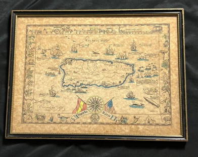
Sold2023Vintage Hand -Colored Pictorial Map of Puerto Rico Circa 1931 by E.B.K. DooleyA vintage hand-colored map of Puerto Rico by E.B.K. Dooley, published c. 1931. This map has a decorative border filled with local plants, wildlife, buildings and transportation. In small scrolls, therSee Sold Price
Sold2016Map of Puerto Rico (San Juan & Vieques), 1895Original engraving from Atlas of the World by Rand McNally, 1895. Features insets of San Juan & Isla of Vieques. Lower section of map page features divisions, islands, lakes, mountains, points of inteSee Sold Price
Sold2018Rand McNally: Antique Map of Puerto Rico, 1899Porto Rico A detailed Puerto Rico map showing the island divided into seven provinces and featuring many place names, roads, railroads, etc, and a gazeteer in the right margin. Below the main map areSee Sold Price
Sold2022CUBA. Vintage map. Inset Puerto Rico. West Indies. Caribbean 1923 oldTITLE/CONTENT OF MAP: 'Cuba; Inset map of Porto Rico' DATE PRINTED: 1923 IMAGE SIZE: Approx 14.5 x 24.0cm, 5.75 x 9.5 inches (Medium); Please note that this is a folding map. TYPE: Vintage colour mapSee Sold Price
Sold2021MID-CENTURY PUERTO RICO MAP PAINTING ON PANELPainted map of Puerto Rico on wood panel. Supposedly from a 1950s restaurant. Apparently unsigned. Dimensions: H 48.5" x W 96" Condition: Paint losses, wood losses, and surface wear. Black rub line MaSee Sold Price
Sold2019Aguadilla (Puerto Rico) by De Ferrer, 1809Title/Content of Map: Aguadilla (Puerto Rico) by De Ferrer, 1809 Date Printed: 1809 Cartographer: José Joaquín de Ferrer Material/Medium: Engraving Size: 11 3/4" x 15" 1809 Nautical Chart of AguadilSee Sold Price
Sold2018Thomson: Puerto Rico & Virgin Islands/HispaniolaMap Title: Puerto Rico and Virgin Isles/Haiti, Hispaniola, or St. Domingo Cartographer: Thomson Place/Date: Edinburgh / 1815/1817 Size: 24" x 20 1/8" Condition: outline color; overall age toning and sSee Sold Price
Sold2022EBK Dooley Hand Colored Puerto Rico Pictorial MapAntique hand colored map of Puerto Rico by EBK Dooley (Eliza Bellows King Dooley), published 1931. No tares and color it still vibrant.See Sold Price
Sold2018Bowen: Antique Map of Hispaniola & Puerto Rico, 1747Title/Content of Map: A New & Accurate Map of Hispaniola or St. Domingo and Porto Rico Cartographer: Bowen Place & Date: London / 1747 Size: 16 1/2" x 6 3/4" Condition: b&w; upper margin added where tSee Sold Price
Sold2017Mallet: Antique Map of Hispaniola / Puerto Rico, 1719Map: Die Inseln Hispaniola und Port Ricco oder dess Reichen Schhavens Cartographer: Mallet Place & Date: Frankfurt / 1719 Size: 4 3/8" x 5 7/8" Condition: full color; overall age toning, some spottingSee Sold Price
Sold2021Cram: Large Puerto Rico Map with San Juan Harbor InsetTitle/Content of Map: Cram: Large Puerto Rico Map with San Juan Harbor Inset Date Printed: 1897, Chicago Cartographer: George Cram Size: 21" x 13" The large Puerto Rico map from Cram's Atlas of the WoSee Sold Price
Sold2022CUBA PUERTO RICO Jamaica Haiti. Caribbean. BAEDEKER 1909 old antique map chartTITLE OF MAP (NOT PRINTED ON THE PAGE):'Cuba and Porto Rico' Places shown on the map include: Jamaica Puerto Rico Haiti DATE PRINTED: 1909 IMAGE SIZE: Approx 10.0 x 15.0cm, 4 x 5.75 inches (Small) TYPSee Sold Price
Sold2018Thomson: Antique Map of Puerto Rico/Hispaniola, 1815Puerto Rico and Virgin Isles/Haiti, Hispaniola, or St. Domingo Two highly detailed topographical maps on a single sheet from Thomson's influential New General Atlas. The upper map is of Puerto Rico anSee Sold Price
Sold2020Century Co.: Puerto Rico and the Lesser AntillesTitle/Content of Map: Century Co.: Puerto Rico and the Lesser Antilles Date Printed: 1898/1913, New York Cartographer: The Century Co. Size: 10 1/2" x 15 1/4" A wonderfully detailed, post Spanish-AmerSee Sold Price
4 days LeftMynt AuctionsCharles Eley English Georgian Sterling Silver Dinner Spoon Engraved Lion 8 1/2"US$10
May 26Mynt AuctionsFINE 925 STERLING SILVER HANDMADE LEAF APPLIQUE MATTE & SHINY SOUP BOWL & TRAYUS$10
Jun 23Schilb Antiquarian Rare BooksUS War w/ SPAIN 1898 1ed Puerto Rico CUBA Philippines MAPS Russell IllustratedUS$1(1 bid)
289 Lots AwayPotter & Potter AuctionsMARTORELL, Antonio (1939 - ). Fly with Trans Caribbean / Puerto Rico. Circa 1960s. Poster...US$125
7 days LeftTemplum Fine Art AuctionsStar Lot our Lady of Carmen Attributed to Jose Campeche y Jordan Puerto Rico 1751 1809 18th€1,500
278 Lots AwayPotter & Potter AuctionsHARDY, John (1923–2004). Puerto Rico / Delta Air Lines. Cir...US$125
22 hrs LeftMynt Auctions1925 USS Los Angeles Puerto Rico Airmail Cover San Juan to Cleveland OH ZeppelinUS$330
6 days LeftMynt Auctions1925 USS Los Angeles Zeppelin Airship Puerto Rico Cover Mayaguez to NY USAUS$330
3 days LeftThe Heritage Gallery at Sayville Antiques, IncCarlos Osorio Abstract Figural Color Crayon Wash DrawingUS$50
417 Lots AwayZikorn Arts & History ObjectsPorto Rico (San Juan) 1671 Engraving by Arnoldus MontanusUS$400
7 days LeftTemplum Fine Art AuctionsCuban or Puerto Rican colonial school of the 17th 18th century Nuestra Senora of Nuria oil on€1,900


![Amér Sep Haiti Domingue 68 Hispaniola Turks Caicos Bahamas VANDERMAELEN 1827 map: TITLE/CONTENT OF MAP: Amér. Sep. - Haïti ou St. Domingue [Iles Bahama ou Lucayes] - No. 68 The map shows Hispaniola (today Haiti and the Dominican Republic), Turks & Caicos and part of the B](https://p1.liveauctioneers.com/5584/271521/142285193_1_x.jpg?height=310&quality=70&version=1670968215)