Sold20191827 American Coast Pilot by Blunt MAPS Nautical Guide1827 American Coast Pilot by Blunt MAPS Nautical Guide Navigation Lighthouses Harbors Originally printed in 1796 (Adams), Edmund Blunt’s ‘American Coast Pilot’ was one of the earliest American wSee Sold Price
Sold20201817 American Coast Pilot by Blunt Nautical MAPS1817 American Coast Pilot by Blunt Nautical MAPS Navigation Lighthouses Harbors Originally printed in 1796 (Adams), Edmund Blunt’s ‘American Coast Pilot’ was one of the earliest American works oSee Sold Price
Sold2018Book Titled The American Coast Pilot 1847By Edmund M. Blunt, including many maps. Provenance: The library of the family Cateau van Rosevelt.See Sold Price
Sold2021(3) 19TH C. MARITIME HANDBOOKSIncluding: Blunt's American Coast Pilot, 15th edition, May 1847, in sailcloth wrap, well-used but complete, scarce in any condition; PLUS ibid 16th edition, with fold-out map, 1850, full calf; PLUS BlSee Sold Price
Sold2016EDMUND MARCH BLUNT (AMERICAN, 1770-1862) MAP OF THEEDMUND MARCH BLUNT (AMERICAN, 1770-1862) MAP OF THE CHESAPEAKE BAY, engraving on laid paper, from Blunt's "The American Coast Pilot", published in New York. Housed under glass in a modern frame. CircaSee Sold Price
Sold2023Maps of North/South Carolina, Charleston HarborMap of North and South Carolina engraved and printed by Ferrier Sears & Co., published by J.T. Hinton, Simpkin & Marshall, 1832..Charleston Harbor Map, engraved for The American Coast Pilot, 14th editSee Sold Price
Sold20231806 hand colored map titled "Ocracock Bar including Shell Castle" from pgs of American Coast PilotA hand colored map of "Ocracock Bar including Shell Castle", a page or partial page most likely taken from the 5th edition of "The American Coast Pilot Containing the Courses and Distances between theSee Sold Price
Sold2022FIVE LEATHERBOUND BOOKS OF MARINE INTEREST 19th CenturyFIVE LEATHERBOUND BOOKS OF MARINE INTEREST19th Century1) Shipmaster’s Assistant & Commercial Digest by Joseph Blunt. N.Y.: E. & G.W. Blunt, 1857.2-3) Two copies of The American Coast Pilot by EdSee Sold Price
Sold2024Early engraving of Newburyport MassEngraving of map of Newburyport Massachusetts published in NY by Edmund and George Blunt - about 6 x 8 inches and was engraved for the American Coastal Pilot 12th ed.See Sold Price
Sold2016Original Imray & Son S. America Coast Chart, 1877Nautical Chart of South American coast, between Rio de la Plata and Valparaiso. Details include Cape Horn Islands, South Shetlands, Falklands, Southern tip of South American coast including Chile andSee Sold Price
Sold2018AN AMERICAN COIN SILVER NAUTICAL PRESENTATION GROUPINGAN AMERICAN COIN SILVER NAUTICAL PRESENTATION GROUPING FROM THE COLLECTION OF CAPTAIN JOHN MELMOTH DOW (American 1827-1892) CIRCA 1855, consisting of a repoussé water pitcher marked "Jones Ball & Co.See Sold Price
Sold2017George Douglas Brewerton (1827-1901) Framed PastelGeorge Douglas Brewerton (American, 1827-1901) framed pastel on paper. Titled "On The Florida Coast" on verso. Measures 24" x 36" (image) and 33" x 45" framed. Signed lower right. Appears to be in excSee Sold Price
Sold20211889 Guide to West Coast Ports, with 3 mapsHeading: Author: Spreckels, J.D. and Frederick K. Samuels, compilers Title: Ports of San Francisco, San Diego, Puget Sound, Portland and Honolulu. (Cover title) Place Published: San Francisco PublishSee Sold Price
Sold2024Anna Pottery Railroad and River Guide FlaskAmerican Second Half 19th Century. Pig Shaped with river and railroad map and inscribed "With a little good old rye in hogs.."See Sold Price
Sold2022PAIR, WILLIAM LORING SAILING OILS, GILTWOOD FRAMESWilliam Cushing Loring (American/Massachusetts, 1879-1959). Pair of nautical oil paintings on academy board depicting Chinese junks sailing of a mountainous coast. Both signed lower right; one with ScSee Sold Price
Sold2022American Nautical Barometer, 20th c.American nautical barometer, the center marked "U.S. Life Saving Service" within a life saver, hook, and oar, the exterior ring reading "Stormy" to "Fair" housed within an oak case. 8.25" squareSee Sold Price
Sold20211827 American Needlework Sampler Mary Barnf19th Century PA Dutch School, Mary M. Barnf, Pictorial Sampler Memento Mori for Sarah Kimball, needlepoint, 12.5 x 12.5 inches, framed in a vine and treestump relief frame measuring 16.5 x 16.5 inchesSee Sold Price
Sold2024An American nautical shadowbox diorama model by Louis GundersonAn American nautical shadowbox diorama model by Louis Gunderson, circa 1900, featuring a harbor with three schooners, tugboat, two villages and a ketch, signed on a flag, 23"h x 45.5"w x 6"d. ProvenanSee Sold Price
Sold2023Hugh Weiss 1925-2007 Pop Art American Map PaintingHugh Weiss (American French, 1925-2007). An original oil painting on canvas. Titled "American Sandwich." A subversive modern Pop Art landscape depicting a stylized map of the 48 contiguous United StatSee Sold Price
Sold2021HAIDA OARHAIDA OAR Haida ceremonial oar, an ancient group of indigenous natives of the Northwestern American coasts. Late XIX Century. 66 cmSee Sold Price
Sold2022Jacob Monk Wall Map of North America 1860Monk's Standard American Map exhibiting the larger portion of North America Embracing The United States and Territories, Mexico, Central America, including the West India Islands, Canada, New BrunswicSee Sold Price
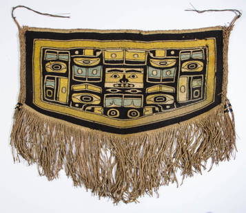
Sold2015NATIVE AMERICAN NORTHWEST COAST CHILD'S CEREMONIALNATIVE AMERICAN NORTHWEST COAST CHILD'S CEREMONIAL CHILKAT BLANKET, the woven panel dyed yellow, blue-green, and black, depicting a central mask surrounded by clan symbols and stylized natural forms,See Sold Price
Sold2019Native American Northwest Coast Carved Horn ScoopVery fine Native American Northwest Coast Carved Horn Scoop. L 8-1/2".See Sold Price
Sold2016Native American N.W. Coast Totem Pole.Hand carved and signed by Ron Austin, 1979. Mounted on a wooden base. Incredible design with five different carved characters. Condition (Very Good - Near Mint). Size 86" T.See Sold Price
18 hrs LeftZikorn Arts & History ObjectsWest Indies, Western Cuba 1879 British Admiralty Nautical MapUS$100
7 days LeftThomaston Place Auction GalleriesCOLLECTION OF TRAVEL EPHEMERA, BROCHURES, BOOKLETS, MAPS 1900-1950US$100
17 hrs LeftPotter & Potter AuctionsBOLLMANN, Hermann (1911 – 1971). Map of New York City. 1962.US$100
18 hrs LeftZikorn Arts & History ObjectsCentral America West Coast 1855 British Admiralty Nautical ChartUS$100(1 bid)
3 days LeftScott Daniel's Auction Signed First Edition : THE WESTERN PONY Leigh, William R.US$300(1 bid)
May 25Auction WallstreetVTG Signed 1983 Duke W Sine Native American Apache Indian Art Print Black White. SBUS$20