Sold2018Antique Survey Map of Earliest American Railroad PlanTitle/Content of Map: 1829 Survey Map of the Earliest American Railroad Plan -- Plan of a Survey for the Proposed Boston and Providence Rail-Way Date Printed: 1828 Boston Cartographer: J Hayward Size:See Sold Price
Sold20211875 h/c map of Florida in fine conditionDetailed map of Florida showing township surveys, forts, canals, swamps, counties, cities, roads, railroads, inland waters, etc. with inset Plan of Florida Keys. Shows Olustee in the north near Lake CSee Sold Price
Sold2024Controller Bay Railroad Survey Map Trio [177997]Linen backed projected location of the Kush Ta Ka Railway 28x76". 1903 blue print style 30x30", tears. 1904 Controller Bay, 30x30", small tears. Controller Bay AlaskaSee Sold Price
Sold2021Interesting 1890s map of AtlantaOriginal 1890s street and railroad map/plan of Atlanta, Georgia by Hunt & Eaton. Has nice detail that shows streets, major buildings, parks, cemeteries, railroads and terminals. A really fine visual pSee Sold Price
Sold2020Williams, R. S. 1856 Lot of 6 California BotanicalLithograph Published 1856, Washington for "Report of Explorations in California for Railroad Routes..." by Lieutenant R. S. Williams. Part of the American Railroad Survey, titled "Reports of exploratiSee Sold Price
Sold2020Williams, R. S. 1856 Lot of 6 California BotanicalLithograph Published 1856, Washington for "Report of Explorations in California for Railroad Routes..." by Lieutenant R. S. Williams. Part of the American Railroad Survey, titled "Reports of exploratiSee Sold Price
Sold2020Williams, R. S. 1856 Lot of 6 California BotanicalLithograph Published 1856, Washington for "Report of Explorations in California for Railroad Routes..." by Lieutenant R. S. Williams. Part of the American Railroad Survey, titled "Reports of exploratiSee Sold Price
Sold20191831 McNeill Map of the Very Early New England RailroadTitle/Content of Map: 1831 McNeill Map of the Very Early New England Railroad Plans -- Map Exhibiting the Several Routes Surveyed for a Proposed Rail Road from Boston to Providence and also to TauntonSee Sold Price
Sold2022(WEST.) William H. Emory. Report on the United States and Mexican Boundary Survey.(WEST.) William H. Emory. Report on the United States and Mexican Boundary Survey. 5 folding maps and plans (one hand-colored), 37 hand-colored lithographic plates (laid down on modern stubs), 288 othSee Sold Price
Sold2023AtlantaPublication Date: 1892 Title: Atlanta Cartographer: CRAM, GEO. F. Publisher: CRAM, GEO. F. Height: 12 Width: 9.8 Map with street plan and railroads. Rev: Map of Milwaukee, Wis. with street plan. ReserSee Sold Price
Sold2021Earliest Obtainable map of 1st Survey of ManhattanTitle: Earliest Obtainable map of 1st Survey of Manhattan Description: "Scarce and most important section of the three-panel lithographed folding map by D. T. Valentine in 1862, replicating the 1664 NSee Sold Price
Sold2017Geological Plan For Pacific Rail Road Surveys Map 18561855-6 Geological Plan For Pacific Rail Road Surveys -- Geological Plan Of The Coastal Range Of California From San Francisco To Los Angeles - No. 1. J Parke / T Antisell, 1856-7 Washington DC, 16.8 XSee Sold Price
Sold2016Cram's Lithographed Map of Oregon, 1881Cram's Railroad and Township Map of Oregon. George F. Cram. Hand-colored Lithographed Map. Chicago: Cram, 1881. from 'The Standard American Railroad Atlas'. 16 1/2 x 20 1/2 inches visible, 25 1/4 x 29See Sold Price
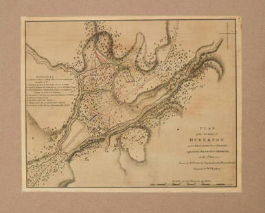
Sold20211780 Faden Map of American Revolutionary War Battle inTitle: 1780 Faden Map of American Revolutionary War Battle in Vermont -- Plan of the Action at Huberton Under Brigadier Genl. Frazer, Supported by Major Genl. Reidesel, on the 7th July 1777 CartographSee Sold Price
Sold2015City Plan of Washington, DC, 1885Original engraving by Captain Greene, 1885. Map shows street plans and railroad systems. Dimensions: 15.5" L x 20" WSee Sold Price
Sold2020Bartholomew, John 1922 Lot of 6 Large Maps. USAIncl North America Political, USA - East, USA - Central, USA - West, North East States, and Sketch Plans of American Cities. Large Lithograph Maps Published 1922 by The Times, London for "The Times SuSee Sold Price
Sold2022Map of All the Railroads in the United States in Operation and Progress.Title: Map of All the Railroads in the United States in Operation and Progress. Cartographer: POOR, H.V./D. & J. McLELLAN Publisher: H.V. POOR | THE AMERICAN RAILROAD JOURNAL Publication Date: c1854 HSee Sold Price
Sold2023Stedman's edition of Faden's plan of the Battle of New York[MAP-AMERICAN REVOLUTION] STEDMAN, CHARLES and FADEN, WILLIAM. A Plan of the Operations of the King's Army under the Command of General Sr. William Howe, K.B. in New York and East New Jersey against tSee Sold Price
Sold2015U.S. Coast Survey Map of South Farallon Island and San(lot of 2) Alexander Dallas Bache (American, 1806 - 1867), South Farallon Island, 1855, and San Clemente Island, 1856, U.S. Coast Survey hand-colored copper engraved maps, overalls (with frames): 18"hSee Sold Price
Sold20181899 US Dept. of Interior Survey Map of Louisiana --Reserve Reduced! Title/Content of Map: 1899 US Dept. of Interior Survey Map of Louisiana -- Louisiana Date: 1899, Baltimore Cartographer: US Dept. of Interior / Bureau of American Ethnology Size: 9.3See Sold Price
Sold2022American Isthmuses. Caribbean 1885 old antique vintage map plan chartTITLE/CONTENT OF MAP: 'American Isthmuses' DATE PRINTED: 1885 IMAGE SIZE: Approx 9.0 x 11.5cm, 3.5 x 4.5 inches (Small) TYPE: Antique wood-engraved map; Scale 155;000;000 CONDITION: Good; suitable forSee Sold Price
Sold20201817 American Coast Pilot by Blunt Nautical MAPS1817 American Coast Pilot by Blunt Nautical MAPS Navigation Lighthouses Harbors Originally printed in 1796 (Adams), Edmund Blunt’s ‘American Coast Pilot’ was one of the earliest American works oSee Sold Price
Sold2018Plan Exhibiting the State of the Surveys in The StateTitle/Content of Map: Plan Exhibiting the State of the Surveys in The State of Florida With References Date Printed: 1855 Cartographer: WESCOTT, JOHN Material/Medium: A. Hoen & Co. Size: 24X26.5 Map sSee Sold Price
Jun 12Dan Morphy AuctionsGEOLOGY OF THE BLACK AND GRAND RAPIDS OF TEXAS INCLUDING THE EASTERN AND WESTERN CROSS TIMBERS,US$100
3 days LeftSchilb Antiquarian Rare Books1869 American Emigrants Immigration Illustrated US State MAPS Railroad AlaskaUS$1(1 bid)
7 hrs LeftRail & Road AuctionsMixed Group of Steamship Books, Brochures, Travel Guides, Post Cards, Magazine, Menu, and MoreUS$40(1 bid)
7 hrs LeftRail & Road AuctionsEleven United States Lines & American Merchant Lines Travel Guides, Brochures, Rates, Menus, andUS$30(1 bid)
7 hrs LeftRail & Road AuctionsSeven Panama Pacific Line Steamship Travel Guides, Timetable, and Menu - 1927 to 1939US$30(1 bid)
May 19Rich Penn AuctionsRailroad, The Official Emblems of the Great American Railroads, collection of 50 ingots minted inUS$70(2 bids)
May 19Rich Penn AuctionsRailroad, American Locomotive Company-New York City Locomotive #3881 w/N.Y.C. & H.R. tender, mattedUS$50
May 19Rich Penn AuctionsRailroad, American Locomotive Company-New York City Locomotive #2400 with B&O Tender, matted in origUS$50
May 22Thomaston Place Auction GalleriesEARLY 17TH C. ELIZABETHAN ENGRAVED MAP OF CORNWALL BY WILLIAM KIP AFTER WILLIAM SAXTONUS$150
May 18Avra Art Auctions TORE ASPLUND (1903-1978, American) WPA Era Railroad Station SceneUS$190(3 bids)
3 days LeftArarity AuctionsAntique 19thC Green Glass Lancaster Glass Works Success to the Railroad Historical American FlaskUS$90(2 bids)
675 Lots AwayBidhausHamilton Railroad H40555131 - American Classic Automatic Black Dial Stainless Steel Men's WatchUS$10(1 bid)
547 Lots AwayBidhausHamilton Railroad H40445955 - American Classic Automatic Silver Dial Stainless Steel Ladies WatchUS$10
4 days LeftFleischer's Auctions1755 Map Partie de l'Amerique Septentrionale, qui comprend Le Cours de L'Ohio...US$200(3 bids)
5 days LeftJasper521861 Mitchell Map of Washington DC -- Plan of the City of Washington The Capitol of the UnitedUS$70


![Controller Bay Railroad Survey Map Trio [177997]: Linen backed projected location of the Kush Ta Ka Railway 28x76". 1903 blue print style 30x30", tears. 1904 Controller Bay, 30x30", small tears. Controller Bay Alaska](https://p1.liveauctioneers.com/2699/324080/174413201_1_x.jpg?height=310&quality=70&version=1711485545)


![Stedman's edition of Faden's plan of the Battle of New York: [MAP-AMERICAN REVOLUTION] STEDMAN, CHARLES and FADEN, WILLIAM. A Plan of the Operations of the King's Army under the Command of General Sr. William Howe, K.B. in New York and East New Jersey against t](https://p1.liveauctioneers.com/292/307340/164259694_1_x.jpg?height=310&quality=70&version=1698409460)


