Sold2024Mitchell - Map of FloridaThis originally hand-colored, lithographed maps is from Samuel Augustus Mitchell's A New Universal Atlas Containing Maps of the various Empires, Kingdoms, States and Republics of the World.. The workSee Sold Price
Sold20181887 Mitchell Map of Florida -- County Map of FloridaTitle/Content of Map: 1887 Mitchell Map of Florida -- County Map of Florida Date: 1887, Philadelphia Cartographer: S Mitchell Size: 10.7 X 14.3 in. Handsome county map of Florida. In this derivative mSee Sold Price
Sold20201860 Mitchell Map of Florida, South and North CarolinaTitle/Content of Map: 1860 Mitchell Map of Florida, South and North Carolina -- County Map of Florida on page with Map of South Carolina, on page with County Map of North Carolina Cartographer: S MitcSee Sold Price
Sold20231860 Mitchell Map of Florida, South and North Carolina -- County Map of Florida on page with Map ofTitle: 1860 Mitchell Map of Florida, South and North Carolina -- County Map of Florida on page with Map of South Carolina, on page with County Map of North Carolina Cartographer: S Mitchell Year / PlaSee Sold Price
Sold20211860 Mitchell Map of Florida, South and North CarolinaTitle: 1860 Mitchell Map of Florida, South and North Carolina -- County Map of Florida on page with Map of South Carolina, on page with County Map of North Carolina Cartographer: S Mitchell Year / PlaSee Sold Price
Sold2017Mitchell Map of Florida, South and North Carolina, 1860Title: 1860 Mitchell Map of Florida, South and North Carolina Cartographer: S Mitchell Published: 1860, Philadelphia Measurements: 10.6 X 13.5 in. County Map of Florida on page with Map of South CarolSee Sold Price
Sold20181863 Mitchell Map of Florida, South and North CarolinaTitle/Content of Map: 1863 Mitchell Map of Florida, South and North Carolina -- County Map of Florida on page with Map of South Carolina, on page with County Map of North Carolina Date: 1863, PhiladelSee Sold Price
Sold20181860 Mitchell Map of Florida, South and North CarolinaTitle/Content of Map: 1860 Mitchell Map of Florida, South and North Carolina -- County Map of Florida on page with Map of South Carolina, on page with County Map of North Carolina Date Printed: 1860,See Sold Price
Sold20201860 Mitchell Map of Florida, South and North CarolinaTitle/Content of Map: 1860 Mitchell Map of Florida, South and North Carolina -- County Map of Florida on page with Map of South Carolina, on page with County Map of North Carolina Date: 1860, PhiladelSee Sold Price
Sold20191860 Mitchell Map of Florida and South Carolina --Title/Content of Map: 1860 Mitchell Map of Florida and South Carolina -- County Map Of Florida [on sheet with] Map Of South Carolina Date: 1860, PhiladelphiaCartographer: S Mitchell Size: 10.8 x 13.2See Sold Price
Sold20221876 Mitchell Map of Florida -- County Map of FloridaTitle: 1876 Mitchell Map of Florida -- County Map of Florida Cartographer: S Mitchell Year / Place: 1876 Philadelphia Map Dimension (in.): 10.6 x 13.5 in. Handsome county map of Florida. Virtually allSee Sold Price
Sold2017Mitchell: Antique Map of Florida, 1848Florida (insets of Pensacola, Tallahassee and Harbour of St. Augustine) S. Augustus Mitchell, 1848. Nice example of an early edition of Mitchell's map of Florida, with insets of Pensacola, TallahasseeSee Sold Price
Sold2017Mitchell: Antique Map of Florida & South Carolina, 1860Map: 1860 Mitchell Map of Florida and South Carolina -- County Map of Florida [on sheet with] County Map of South Carolina Date Printed: 1860, Philadelphia Cartographer: S Mitchell Size: 9.1 x 10.6 inSee Sold Price
Sold20181874 Mitchell Antique Map of FloridaTitle/Content of Map: 1874 Mitchell Map of Florida -- County Map of Florida Date Printed: 1874 Philadelphia Cartographer: S Mitchell Size: 10.6 X 13.5 Handsome county map of Florida. Virtually all ofSee Sold Price
Sold2016Mitchell: County Map of Florida 1867Map: County Map of Florida Maker: Mitchell Size: 11 x 13.25 inches Counties in original wash color. Inset of Mobile, AL. No Reserve: This lot starts at $1 and has no reserve as a courtesy so that collSee Sold Price
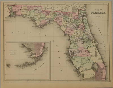
Sold20211883 Mitchell/Bradley Map of Florida -- County Map ofTitle: 1883 Mitchell/Bradley Map of Florida -- County Map of Florida Cartographer: Mitchell / Bradley Year / Place: 1883, Philadelphia Map Dimension (in.): 10.5 X 14.4 in. This is a rather handsome coSee Sold Price
Sold2018Mitchell: Antique County Map of Florida, 1870County Map of Florida The beautifully detailed and colored county map of Florida from the 1870 edition of Mitchell's popular New General Atlas of the world. Framed by the vine motif border typical ofSee Sold Price
Sold20231847 Mitchell atlas complete w/all maps in excellent conditionVery scarce 1847 New Universal Atlas published by S. Augustus Mitchell, complete with all maps and in sound, clean condition. Contains 72 lithographed maps as called-for, all with original, full hand-See Sold Price
Sold2023Rare 1st state of Florida map from 1st printing of 1860 atlasFirst edition, first state of S. A. Mitchell Jr.'s County Map of Florida/County Map of South Carolina. Maps from Mitchell Jr’s first printing of his first New General Atlas are distinguished bySee Sold Price
Sold2023MAPS: MITCHELL NEW ORLEANS, FLORIDA, ARKANSASUnframed map, Samuel Augustus Mitchell, Jr., copyright 1882, depicting "Plan of New Orleans, "Country Map of Florida" on one side, "County Map of the States of Arkansas, Mississippi and Louisiana" onSee Sold Price
Sold202118th-19th C. Botanical and Nautical printsincludes 4 Botanical plates 1790's by W. Curtis a 19th C. Map of France, Mitchell, 1847. Battle of Trafalgar, October 21st 1805, from 'The Naval Achievements of Great Britain' by James Jenkins, engravSee Sold Price
Sold2019Samuel Augustus Mitchell (1790-1868), "County Map ofSamuel Augustus Mitchell (1790-1868), "County Map of Florida," 1867, Atlas, with an inset of Mobile, H.- 12 in., W.- 12 3/8 in.See Sold Price
Sold2019Samuel Augustus Mitchell (1790-1868), "County Map ofSamuel Augustus Mitchell (1790-1868), "County Map of Florida, North Carolina, South Carolina," 1860, H. - 12 1/4 in., W. - 15 3/8 in.See Sold Price
Sold20231891 Mitchell Map of Southern States -- Map of Georgia, Florida, Alabama, Mississippi andTitle: 1891 Mitchell Map of Southern States -- Map of Georgia, Florida, Alabama, Mississippi and Tennessee.. Cartographer: S Mitchell Year / Place: 1891, Philadelphia Map Dimension (in.): 10.6 X 8.2 iSee Sold Price
7 days LeftJasper521872 Mitchell Map of Louisiana, Arkansas and Mississippi -- County Map of the States of Arkansas,US$40
7 days LeftJasper521872 Mitchell Map of Massachussetts, Connecticut and Rhode Island -- County Map of Massachussetts,US$40
7 days LeftJasper521878 Mitchell Map of Georgia and Alabama -- County Map of the States of Georgia and AlabamaUS$50
7 days LeftJasper521887 Mitchell Map of New Mexico and Arizona -- County and Township Map of Arizona and New MexicoUS$80
3 days LeftSimpson Galleries, LLC.J.H. Young (1792-1870) AN AMERICAN FEDERAL PERIOD MAP, "Mitchell's Travellers Guide Through theUS$500
Jun 12Jasper52Amér. Sep. Florides et Iles Lucayes #62 Florida & Bahamas. VANDERMAELEN 1827 mapUS$400
Jun 13Swann Auction Galleries(NORTH AMERICA.) Samuel Augustus Mitchell. New National Map, Exhibiting the United States with theUS$450
Jun 13Swann Auction Galleries(CHESAPEAKE -- VIRGINIA.) Group of 7 seventeenth-to-eighteenth-century engraved maps of Virginia andUS$1,100
Jun 14DuMouchellesWilliam H. Gamble (American, B. 1863) Hand Colored Engraving, Ca. 1863, "County Map of Michigan AndUS$50(1 bid)
BonhamsMITCHELL (SAMUEL AUGUSTUS) A New Universal Atlas Containing Maps of the Various Empires, Kingdom...£1,300


![1860 Mitchell Map of Florida and South Carolina --: Title/Content of Map: 1860 Mitchell Map of Florida and South Carolina -- County Map Of Florida [on sheet with] Map Of South Carolina Date: 1860, PhiladelphiaCartographer: S Mitchell Size: 10.8 x 13.2](https://p1.liveauctioneers.com/5584/144953/73284299_1_x.jpg?height=310&quality=70&version=1562102885)


![Mitchell: Antique Map of Florida & South Carolina, 1860: Map: 1860 Mitchell Map of Florida and South Carolina -- County Map of Florida [on sheet with] County Map of South Carolina Date Printed: 1860, Philadelphia Cartographer: S Mitchell Size: 9.1 x 10.6 in](https://p1.liveauctioneers.com/5584/109294/56069180_1_x.jpg?height=310&quality=70&version=1505338533)