Sold20231855 Beckwith Map of Northern Utah and Nevada -- Map No. 2 From Great Salt Lake to the HumboldtTitle: 1855 Beckwith Map of Northern Utah and Nevada -- Map No. 2 From Great Salt Lake to the Humboldt Mountains from Explorations and Surveys Made Under the Direction of Hon. Jefferson Davis, Sec. ofSee Sold Price
Sold20221855 Beckwith Map of Northern Utah and Nevada -- MapTitle: 1855 Beckwith Map of Northern Utah and Nevada -- Map No. 2 From Great Salt Lake to the Humboldt Mountains from Explorations and Surveys Made Under the Direction of Hon. Jefferson Davis, Sec. ofSee Sold Price
Sold20221855 Beckwith Map of Northern Utah -- Map No. 1 FromTitle: 1855 Beckwith Map of Northern Utah -- Map No. 1 From the Valley of Green River to the Great Salt Lake from Explorations and Surveys Made Under the Direction of Hon. Jefferson Davis, Sec. of WarSee Sold Price
Sold20231855 Beckwith Map of Nevada and Northern California -- Map No. 4 From the Valley of the Mud Lakes toTitle: 1855 Beckwith Map of Nevada and Northern California -- Map No. 4 From the Valley of the Mud Lakes to the Pacific Ocean from Explorations and Surveys Made Under the Direction of Hon. Jefferson DSee Sold Price
Sold20231855 Beckwith Map of Nevada -- Map No. 3 From the Humboldt Mountains to the Mud Lakes fromTitle: 1855 Beckwith Map of Nevada -- Map No. 3 From the Humboldt Mountains to the Mud Lakes from Explorations and Surveys Made Under the Direction of Hon. Jefferson Davis, Sec. of War… CartograSee Sold Price
Sold2021Impressive & scarce map of N. Calif/Nevada, 1882Two-page map of Northern California, Nevada Territory and western portion of Utah from the extremely scarce 1882 Cram’s Unrivaled Family Atlas of the World. The only Cram atlas maps that were haSee Sold Price
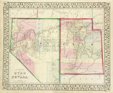
Sold2018Mitchell: Antique Map of Utah and Nevada,1870Title/Content of Map: 1870 Mitchell Map of Utah and Nevada -- County Map of Utah and Nevada Date Printed: 1870 Philadelphia Cartographer: S Mitchell Size: 10.6 X 13.5 in. Handsome county map of Utah aSee Sold Price
Sold2022Nevada & Utah 1880Title/Content of Map: Nevada & Utah 1880 Date Printed: 1880 Material/Medium: paper Size: folio, 23x 15 inches Additional Info: Hand colored county & township map of Utah & Nevada by Mitchell. Map measSee Sold Price
Sold20211855 Gunnison Map of Colorado and Utah -- Map No. 4Title: 1855 Gunnison Map of Colorado and Utah -- Map No. 4 From the Coo-Che-To-Pass to the Wahsatch Mountains Under the direction of the Hon. Jefferson Davis… Cartographer: J Gunnison Year / Place:See Sold Price
Sold20231881 Map of Utah & Nevada by Mitchell1881 Map of Utah & Nevada by Mitchell. Overall size 22 1/2"h x 29 1/2"wSee Sold Price
Sold20201892 Cowles Civil War Map of Utah, Nevada and Most ofTitle: 1892 Cowles Civil War Map of Utah, Nevada and Most of California plus March Route of the Army of Tennessee -- Territory and Military Department of Utah…1860 [and] March Routes of Army of TennSee Sold Price
Sold2017Mitchell: Antique County Map of Utah & Nevada, 1870[Utah, Nevada]. N. p: S. Augustus Mitchell, 1870s. The map was drawn and engraved by W. H. Gamble of Philadelphia. Coloured map. Approximately 11-3/4 x 14-/4 inches image area, one sheet, matted. FineSee Sold Price
Sold20221855 Colton Map of Northern Italy -- Northern ItalyTitle: 1855 Colton Map of Northern Italy -- Northern Italy Cartographer: J Colton Year / Place: 1855, New York Map Dimension (in.): 11.8 X 14.6 in. This is a very nice map of Northern Italy, slighly pSee Sold Price
Sold20241855 Colton Map of Northern Germany -- Germany No. 1Title: 1855 Colton Map of Northern Germany -- Germany No. 1 Cartographer: J Colton Year / Place: 1855, New York Map Dimension (in.): 11.8 X 14.6 in. This is a very nice map of Northern Germany with inSee Sold Price
Sold2019Mitchell: County Map of Utah & NevadaMap Title: County Map of Utah and NevadaCartographer: S. A. Mitchell Place/Date: Philadelphia / 1870 Size: 14" x 11 5/8" Condition: full color; light overall age toning The beautifully detailed and coSee Sold Price
Sold2020USA 1903 Lot of 6 State Maps. California, Utah, NevadaPlus Washington, Colorada and Arizona/New Mexico. Lithograph Maps Published 1903 by Adam & Charles Black, Edinburgh & London for "Encyclopaedia Brittannica" Tenth Edition. Centre fold as published. PaSee Sold Price
Sold20231877 Mitchell Map of Utah and Nevada [verso] Arizona and New Mexico -- County Map of of Utah andTitle: 1877 Mitchell Map of Utah and Nevada [verso] Arizona and New Mexico -- County Map of of Utah and Nevada [verso] County Map Arizona and New Mexico Cartographer: S Mitchell Year / Place: 1877 PhiSee Sold Price
Sold20191876 Mitchell Map of Utah and Nevada [verso] ArizonaTitle/Content of Map: 1876 Mitchell Map of Utah and Nevada [verso] Arizona and New Mexico -- County Map of of Utah and Nevada [verso] County Map Arizona and New Mexico Date: 1876 Philadelphia CartograSee Sold Price
Sold2017VINTAGE MAPS AND MOREVINTAGE MAPS - UTAH OIL REFINING COMPANY - WESTERN STATES - SHELL - MAP OF NEVADA/UTAH AND ARIZONA/NEW MEXICO - RPM MOTOR OIL MAP - CALIFORNIA POINTS OF INTEREST AND TOURING MAP - AND MANY MORE - ALLSee Sold Price
Sold2023Scarce Johnson map of the Great Western states, 1864Authentic vintage map of California, Utah, Nevada, Colorado, New Mexico, and Arizona. Created during a great time of expansion and change in the western United States while the Civil War was still ragSee Sold Price
Sold2019California Southwest Antique MapEarly map: California, also Utah, Nevada, Colorado, New Mexico and Arizona. Map by A.J. Johnson, New York, c. 1870. 18" x 26 1/2".See Sold Price
Sold2017Colton: Map of California Nevada Utah Colorado ArizonaColton's Map of California, Nevada, Utah, Colorado, Arizona & New Mexico, 1865/1869. Early edition of Colton's map of the Southwestern United States. Unlike in the prior edition, Nevada is no longer tSee Sold Price
Sold2017Colton: Antique Map of Northern Italy, 1855Map: 1855 Colton Map of Northern Italy -- Northern Italy Date Printed: 1855 New York Cartographer: J Colton Size: 13 X 15.5 in. Condition: Very good. Colored. Slight marginal toning. A modest chip inSee Sold Price
Sold2021Bancroft's California, Nevada, etc. 1864Heading: Author: Bancroft, Hubert Howe Title: Bancroft's Map of California, Nevada, Utah and Arizona Place Published: San Francisco Publisher:H.H. Bancroft & Company Date Published: 1864See Sold Price
6 days LeftAlbion AuctionsNat. Encyclo. 1890's Pair of Celestial Maps. Northern & Southern ConstellationsUS$10(2 bids)
5 days LeftJasper52BALKANS. Northern Turkey In Europe. Rumilia Wallachia. ARROWSMITH 1828 old mapUS$20
Featured4 days LeftJasper521716 Homann Map of Northern Germany -- Circulus Saxoniae Inferioris in omnes suos Status etUS$95
4 hrs LeftTrillium Antique Prints & Rare BooksBonne - Pair of Maps (Eastern & Northern Hemisphere)US$75
4 days LeftJasper521730 Covens & Mortier Map of North Coast of Africa and Southern Europe -- In Notitiam EcclesiasticamUS$80
6 days LeftAlbion AuctionsGentleman's Magazine 1778 Canal Map. Belfast to Loughneagh Northern IrelandUS$5(1 bid)
5 days LeftJasper52Turkey in Europe. Balkans. Scarce edition w/o vignettes. TALLIS/RAPKIN 1855 mapUS$55
4 days LeftJasper521855 Fullarton Map of Russia -- Russian Empire According To Kiepert and OthersUS$55
4 days LeftJasper521858 Mitchell Map of Great Britain and Ireland [verso] Germany and Switzerland -- No. 22 Map ofUS$25
5 days LeftJasper52PRAETORIAN PREFECTURE OF GAUL. 'Grande Prefecture des Gaules'. MALLET 1683 mapUS$20
5 days LeftJasper52BALKANS. Northern Ottoman provinces. Wallachia Bulgaria Albania. SDUK 1844 mapUS$40
5 days LeftZikorn Arts & History ObjectsCentral America West Coast 1855 British Admiralty Nautical ChartUS$100(1 bid)
5 days LeftPotter & Potter AuctionsLINDGREN, Hjalmer “Jolly” (1895–1952). A Hysterical Map of ...US$150(1 bid)
1 day LeftSchilb Antiquarian Rare Books1859 AFRICA VOYAGES Barth Timbuktu Tripoli SLAVES Illustrated Slavery MAP AfricanUS$105(5 bids)
May 22Thomaston Place Auction GalleriesCOLLECTION OF TRAVEL EPHEMERA, BROCHURES, BOOKLETS, MAPS 1900-1950US$100


![1892 Cowles Civil War Map of Utah, Nevada and Most of: Title: 1892 Cowles Civil War Map of Utah, Nevada and Most of California plus March Route of the Army of Tennessee -- Territory and Military Department of Utah…1860 [and] March Routes of Army of Tenn](https://p1.liveauctioneers.com/5584/162681/82155385_1_x.jpg?height=310&quality=70&version=1583273475)
![Mitchell: Antique County Map of Utah & Nevada, 1870: [Utah, Nevada]. N. p: S. Augustus Mitchell, 1870s. The map was drawn and engraved by W. H. Gamble of Philadelphia. Coloured map. Approximately 11-3/4 x 14-/4 inches image area, one sheet, matted. Fine](https://p1.liveauctioneers.com/5584/107399/55057774_1_x.jpg?height=310&quality=70&version=1501794677)


![1877 Mitchell Map of Utah and Nevada [verso] Arizona and New Mexico -- County Map of of Utah and: Title: 1877 Mitchell Map of Utah and Nevada [verso] Arizona and New Mexico -- County Map of of Utah and Nevada [verso] County Map Arizona and New Mexico Cartographer: S Mitchell Year / Place: 1877 Phi](https://p1.liveauctioneers.com/5584/293457/155766077_1_x.jpg?height=310&quality=70&version=1687903812)
![1876 Mitchell Map of Utah and Nevada [verso] Arizona: Title/Content of Map: 1876 Mitchell Map of Utah and Nevada [verso] Arizona and New Mexico -- County Map of of Utah and Nevada [verso] County Map Arizona and New Mexico Date: 1876 Philadelphia Cartogra](https://p1.liveauctioneers.com/5584/137769/69881187_1_x.jpg?height=310&quality=70&version=1552435690)


![1858 Mitchell Map of Great Britain and Ireland [verso] Germany and Switzerland -- No. 22 Map of (1 of 2)](https://p1.liveauctioneers.com/5584/328338/176911589_1_x.jpg?height=282&quality=70&version=1715113718)


