Sold20191868 Bowles Rocky Mountains MAP Mormon Polygamy INDIANS1868 Bowles Rocky Mountains MAP Mormon Polygamy INDIANS California Pacific Samuel Bowles’s ‘Across the Continent’ is a Civil War-era book that covers the authors journey with Schuyler Colfax andSee Sold Price
Sold2020Currier & Ives, The Indian Pass. Rocky MountainsCURRIER, Nathaniel (1813 - 1888) and IVES, James Merritt (1824 - 1895).The Indian Pass. Rocky Mountains.Lithograph with original hand color.New York: Currier & Ives, late 1850's.11 1/2" x 17 3/4" sheeSee Sold Price
Sold2020Currier & Ives, The Rocky Mountains.CURRIER, Nathaniel (1813 - 1888) and IVES, James Merritt (1824 - 1895).The Rocky Mountains.Lithograph with original hand color.New York: Currier & Ives.10 1/4" x 14 1/4" sheet.Gale Number: 5632.See Sold Price
Sold2018First Precise Map of the Great BasinHeading: Author: Stansbury, Howard Title: Exploration and Survey of the Valley of the Great Salt Lake of Utah, Including a Reconnoissance of a New Route Through the Rocky Mountains (Map Volume Only)See Sold Price
Sold20211871 1ed Westward Railroads Rae California Utah Mormons1871 1ed Westward Railroads Rae California Utah Mormons Rocky Mountains MAP Rae was a correspondent in the US and Canada for the British paper, the Daily News. “Westward by Rail” is his observatioSee Sold Price
Sold2023Landscape LotLot consisting of a large Rocky Mountain lithograph (22" x 33") , booklet of NH landscapes and a set of 5 landscape lithographs.See Sold Price
Sold2022John J. Audubon Rocky Mountain Hare LithographJohn James AudubonUnited States,19th Century A later 19th C. printing, titled "Lepus Townsendii Townsend's Rocky Mountain Hare," depicts a male and female hare looking off into the distance from JohnSee Sold Price
Sold2022AUDUBON ROCKY MOUNTAIN GOAT LITHOGRAPHAUDUBON, John James (1785-1851). Rocky Mountain Goat, Plate 128. Lithograph with from the Viviparous Quadrupeds of North America, Imperial Folio. Philadelphia: J, T. Bowen, 1839-1844. Measures 26 1/2"See Sold Price
Sold2022Audubon "Ovis Montana, Rocky Mountain Sheep" LithographExcellent in walnut burl frame, matted and sealed under plexi-glass. Has a scratch on the plexi. Male and Female. Lithograph colored and printed by J.T Bowen Philadelphia. Sight size: 20" x 26"See Sold Price
Sold2022J.J. Audubon Rocky Mountain Neotoma Lithograph.John James Audubon Rocky Mountain Neotoma, Plate 29. (1785-1851). First edition large folio lithograph with original hand color. The Viviparous Quadrupeds of North America J.J. Audubon, New York, 1845See Sold Price
Sold2016James Smillie, (American, 1807-1885), The RockyJames Smillie, (American, 1807-1885), The Rocky Mountains, 1866 (After Albert Bierstadt), engraving with roulet, signed in pencil lower right, 16.75" x 27.75" Provenance: Provenance: Wunderlich & CompSee Sold Price
Sold2022(WEST.) Samuel Parker. Journal of an Exploring Tour Beyond the Rocky Mountains.(WEST.) Samuel Parker. Journal of an Exploring Tour Beyond the Rocky Mountains. Folding map, plate. 408 pages. 12mo, publisher's cloth; lacking front flyleaf, moderate foxing; early signature and lateSee Sold Price
Sold2018Audubon Lithograph, Rocky Mountain GoatAUDUBON, John James (1785-1851). Rocky Mountain Goat, Plate 128. Lithograph with original handcolor from the Viviparous Quadrupeds of North America, Imperial Folio. Philadelphia: J, T. Bowen, 1839-184See Sold Price
Sold2024Coltons Map 1856 Rocky Mountains Captain Bonneville 12 x 18"Map came out of a book in excellent condition. Paper feels like rice paper. Guaranteed from the period. Approximately 12 X 18". Shipping includes insurance. Shipping: Domestic: Flat-rate of $12.00 toSee Sold Price
Sold20211860 Tinted Lithograph Lewis and Clarks PassA tinted lithograph of "Rocky Mountains, Looking Westward" of "Lewis and Clarks Pass", printed by Sarony and Major at New York. From a Government Report and nice card stock. Fine with light discoloratSee Sold Price
Sold2023Harpers Weekly Engraving Hand Colored, A Tornado in the Rocky Mountains, Sept. 19, 1885A Tornado in the Rocky Mountains, Sept. 19, 1885. Approx. 15 5/8 x 22 in. (paper). Discoloration from previous mat. Light wear to edges. Small paper loss lower right corner. Dry mounted to paper backiSee Sold Price
Sold2020Map of the Rocky Mountain RegionTitle/Content of Map: Map of the Rocky Mountain Region Date: 1885 Cartographer: E. T. Ensign Publisher: U.S. Dept. of Agriculture Size: 30.75”Height - 18.75”Width showing the approximate lSee Sold Price
Sold20211853-4 Stevens Map of the Rockies to Washington StateTitle: 1853-4 Stevens Map of the Rockies to Washington State -- Map No. 3 Rocky Mountains to Puget Sound… Cartographer: I Stevens Year / Place: 1853-4, Washington Map Dimension (in.): 24.5 X 36.See Sold Price
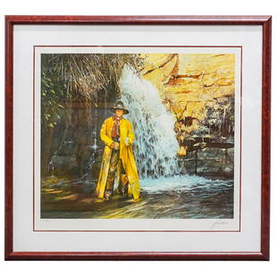
Sold2023Gordon Snidow (B. 1936) "The Rocky Mountain Legend" LithoDESCRIPTION: Lithograph entitled "The Rocky Mountain Legend" by Gordon Snidow from his Coors collection of Coors beer advertisements depicting a person in a yellow trench coat and cowboy garb holdingSee Sold Price
Sold2022Lot 5 books Americana Travel Military HistoryLot of 5 books related to Americana: Samuel Parker, Journal of an Exploring Tour Beyond the Rocky Mountains, third edition, 1842, lacks maps, other plate present; George Bodge, Soldiers in King PhilipSee Sold Price
Sold2017Ettling: Map of United States of North America, 1860United States of North America (Eastern & Central) T. J. Ettling, c1860 17 x 25. This great Civil War era map covers the country from the Rocky Mountains to the Atlantic seaboard. The map is engravedSee Sold Price
Sold2020Fremont's Narrative with Rufus Sage Map 1847Heading: Author: Frémont, John Charles Title: Narrative of the Exploring Expedition to the Rocky Mountains, in the year 1842; and to Oregon and North California, in the Years 1843-44 Place PublishedSee Sold Price
Sold2022Rare 1836 Col. Dodge Expedition map - 1st printing, SteenLarge and important early copper engraved map of the western U. S. showing the route of Col. Henry Dodge’s 1835 Expedition from Fort Leavenworth to the Rocky Mountains. Rare first printing withSee Sold Price
Sold20181842-44 Fremont Expedition Map of Rockies, OR and CA --Title/Content of Map: 1842-44 Fremont Expedition Map of Rockies, OR and CA -- Report of the Exploring Expedition to the Rocky Mountains in the Year 1842, and to Oregon and North California in the YearSee Sold Price
Jun 07Freeman's | HindmanCURRIER and IVES, publishers -- After Frances F. Palmer. The Rocky Mountains. Emigrants Crossing theUS$4,000
16 hrs LeftPotter & Potter AuctionsPOLAND, Edwin Christian (1903 – 1991). The Evergreen Playgr...US$200
3 days LeftTrillium Antique Prints & Rare BooksAudubon - Townsend's Rocky Mountain Hare. 3US$25(1 bid)
16 hrs LeftPotter & Potter AuctionsHANDY, R.D. (1879 – 1959). Paul Bunyan’s Pictorial Map of t...US$200(1 bid)
Jun 02Schilb Antiquarian Rare Books1856 Fremont Illustrated American Exploration California Rocky Mountains SmuckerUS$1(1 bid)
May 30NY Elizabeth 1846 ALTOWAN INCIDENTS OF LIFE & ADVENTURE IN THE HISTORIC ROCKY MOUNTAINS, USAUS$50
1 hr LeftJasper52Balkans 1878 Treaty of Berlin. Bulgaria Eastern Roumelia Turkey GRAPHIC 1885 mapUS$55
Jun 23Schilb Antiquarian Rare Books1889 Rocky Mountains Americana Lewis & Clark GOLD Sioux Indians Mormons RailroadUS$1
May 27Donny Malone AuctionsSigned Bailet, Oil on Canvas Painting, Rocky Mountains Landscape, FramedUS$10
2 days LeftEDEN Fine Antiques GalleriesLARGE CHINESE EMBROIDERY SILK DRAGON MOTIF ON YELLOW GROUNDUS$700(3 bids)