Sold201818th Map of French Region PicardieTopographical map of government of Castelet, dated 17th C, printed within an acanthuis border. S:17.5"H x 21.5"W F: 28"H x 31.5"WSee Sold Price
Sold201518th C French Map Of SteenvoordePLOUICH, Vedastus du -" Illvstrissimo viro domino" .The city of Steenvoorde is a small town located north of France. The city of Steenvoorde is located in the department of Nord of the french region.See Sold Price
Sold2020Group of French Maps Guillaume de l'Isle SansonGroup of four 17th and 18th century French maps. Guillaume Delisle (1675-1726) hand colored engraved map of Picardie, 1748. Two maps by Nicolas Sanson (1600-1677), "Le Roayaume de France" and "GouvernSee Sold Price
Sold2023Early Hand Colored Map French Region, approx. 26" X 33"Early Hand Colored Map French Region, approx. 26" X 33"See Sold Price
Sold2017Victor Levasseur, (4) maps French regionsVictor Levasseur, (4) maps French regions, Victor Levasseur (French, 1800-1870), Pyrenees, L'Ariege, and Puy de Dome, c. 1856, hand-colored engravings with vignettes and decorative borders, each 14.5"See Sold Price
Sold2019Rare map of French region of Lunguedoc with 12 cityTitle/Content of Map: Rare map of French region of Lunguedoc with 12 city views including Montpelier. Date: 1717 Cartographer: Feuille Size: 7.6x10.6” Provenance: Amsterdam Additional Info: OriginalSee Sold Price
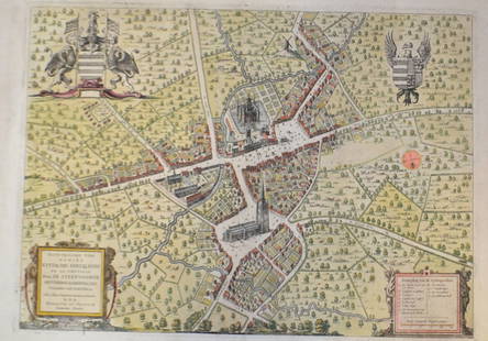
Sold20211750 Homann Map of French Champaigne Region -- TabulaTitle: 1750 Homann Map of French Champaigne Region -- Tabula Geographica Campaniae Cartographer: J Homann [Family] Year / Place: 1750 c., Nurnberg Map Dimension (in.): 22.3 X 19.1 in. This is a lovelySee Sold Price
Sold20211881 Vuillemin Map of French Alsace Region -- LaTitle: 1881 Vuillemin Map of French Alsace Region -- La France. Ht-Rhin Cartographer: A Vuillemin Year / Place: 1881 Paris Map Dimension (in.): 9.4 X 7 in Description: This is a very nice map of the sSee Sold Price
Sold201718th C. French Map w/ Oiled Paper, ex-Sotheby'sEurope, France, map from 1709 CE, oiled paper overlays from 1756 to 1763 CE, owned by Louis-Alexandre Berthier (1753 to 1815 CE), Marshal, Vice-Constable of France, and Chief of Staff (Major general)See Sold Price
Sold201718th Century French Map of North AmericaL’Amerique Septentrionale. Daniel de la Feuille (1640-1709). Engraved map with hand color in full. Amsterdam, 1702 or 1706. 6 x 8 inches visible, 13 x 14 1/2 inches framed. Nicely colored early 18thSee Sold Price
Sold202118th C. French Map "Le Noveau Mexique …"Ribobert Bonne (French, 1727-1794). "Le Nouveau Mexique, Avec La Partie Septentrionale De L'Ancien, ou De La Nouvelle Espagne" Published in Paris, 1780. Among the most collected late 18th century mapsSee Sold Price
Sold202118TH CENTURY FRENCH MAP OF SOUTHEASTERN USRigobert Bonne (French, 1727-1794). "Carte De la Partie Sud Des Etats Unis De L'Amerique Septentrionale" -circa 1780, engraving. Provenance: From the Lifetime Collection of Billy S. Arant, Jr., ChattaSee Sold Price
Sold2018Framed 18th C. French Map of Ancient Rome**First Time At Auction** Louis Brion de la Tour (French, 1743-1810) & Louis Charles Desnos (French, 1725-1805), "Suite De L'Histoire De Rome", ca. 1760 to 1770. Copperplate engraved with original hanSee Sold Price
Sold2019.18th Century French Map of Cuba, Florida and Louisiana21 1/4 x 16 3/4 in. (framed).18th Century French Map of Cuba, Florida and LouisianaGulf of Mexico antique map Golfe du Mexique Zannoni 1762Title: Carte Geo-Hydrographique du Golfe du Mexique et de sesSee Sold Price
Sold202118TH CENTURY FRENCH MAP OF THE WORLDDimensions: Frame: H 14.5" x W 19.35" Sight: H 9.25" x W 13.75" Condition: Discolored old watercolor, some toning to mat.See Sold Price
Sold20241602 Ortelius Map of French Le Mans region -- La Mans Cenomanorum TypusTitle: 1602 Ortelius Map of French Le Mans region -- La Mans Cenomanorum Typus Cartographer: A Ortelius Year / Place: 1602, Antwerp Map Dimension (in.): 3 X 4.2 in. This is a charming smaller map of FSee Sold Price
Sold2021Pair 18th C French Maps after the AntiqueTo include "A View of the Town-House or Guild Hall of Paris" and "Vue de Chateau Royal D'amboise" : mid 20th century prints after the antique, housed in concave giltwood frames. Copperplate engravingsSee Sold Price
Sold20211680 Visscher Map of French and Italian Alpine RegionTitle: 1680 Visscher Map of French and Italian Alpine Region -- Regiae Celsitudinis Sabaudicae Status Cartographer: N Visscher Year / Place: 1680 c. Amsterdam Map Dimension (in.): 22.8 X 19.8 in. ThisSee Sold Price
Sold2018FRENCH 18TH CENTURY MAP OF BOSTON, MASSACHUSETTSFRENCH 18TH CENTURY MAP OF BOSTON, MASSACHUSETTS, on laid paper, title in top center "PLAN DE BOSTON", most likely Georges-Louis Le Rouge (French, c. 1712 to 1790), probably after John Bonner (EnglishSee Sold Price
Sold2024Exceptional 18th Century Map of The Carolinas, Maryland and VirginiaBy Johann Baptist Homann, Germany, late 17th/early 18th century. Hand colored map of the region which is excellent and quite rare. The map giving excellent details of the region and having exquisite eSee Sold Price
Sold2022GUILLAUME DE LISLE (1675-1726), AN 18TH CENTURY FRENCHGUILLAUME DE LISLE (1675-1726), AN 18TH CENTURY FRENCH COLONIAL MAP, "Carte de la Louisiane et de Cours du Mississipi," AMSTERDAM, CIRCA 1727, engraving on paper with ink inscriptions, after GuillaumeSee Sold Price
Sold20181573 Ortelius Map of French Riviera and Italy'sTitle/Content of Map: 1573 Ortelius Map of French Riviera and Italy's Piedmont Region -- Pedemontanae Vicinorumque Regionum Auctore Iacobo Castaldo Descrip Date Printed: 1573, Antwerp Cartographer: ASee Sold Price
Sold2019Artois region along French Belgian borderTitle/Content of Map: Artois region along French Belgian border Date: 1717Cartographer: by FeuilleSize: 7.6x10.6” Provenance: Amsterdam original hand color/ Note* some damage on left due to strong fSee Sold Price
5 hrs LeftJasper521692 Peeters Map of Southeast France -- Ducatus Saboudiae Principatus Pedemontii ComitatusUS$70
5 days LeftCollective HudsonFrench School of Jean-Baptiste Greuze - Pastel Painting, 18th/19th CenturyUS$800
Jun 15Riverfront Auctions'1785 Bocage Map of the City of Athens in Ancient Greece' Par M. Barbié du BocageUS$5
4 hrs LeftJasper521758 MAP PARTIE DE LA MER GLACIALE contenants La Nouvelle Zemble RUSSIA antiqueUS$55
May 30NY Elizabeth 1792 OLD INDIA HISTORY ANTIQUE ILLUSTRATED WITH MAPS OF THE EIGHTEENTH CENTURY IN FRENCHUS$50
May 30NY Elizabeth D. BLONDEL GENEALOGIAE FRANCICAE VELLUM ANCIENT FOLIO MAPS 1654 HISTORY OF FRANCEUS$50
4 days LeftAGOPBA French 18th Century Verdure Tapestry with birds in a forest landscape with water, 82 1/2" h. 75US$275(2 bids)
2 days LeftHannam's Auctioneers LtdAN 18TH CENTURY FRENCH SEVRES PORCELAIN CREAM JUG painted with flowers. 9 cm x 8 cm.£60


![1750 Homann Map of French Champaigne Region -- Tabula: Title: 1750 Homann Map of French Champaigne Region -- Tabula Geographica Campaniae Cartographer: J Homann [Family] Year / Place: 1750 c., Nurnberg Map Dimension (in.): 22.3 X 19.1 in. This is a lovely](https://p1.liveauctioneers.com/5584/227445/117579454_1_x.jpg?height=310&quality=70&version=1638310644)


