Sold2018FRENCH 18TH CENTURY MAP OF BOSTON, MASSACHUSETTSFRENCH 18TH CENTURY MAP OF BOSTON, MASSACHUSETTS, on laid paper, title in top center "PLAN DE BOSTON", most likely Georges-Louis Le Rouge (French, c. 1712 to 1790), probably after John Bonner (EnglishSee Sold Price
Sold2020Louis XVI Carved and Painted TrumeauFrench, mid-18th C. Reduced in height. 5'6"h x 34"w Provenance: Property from the Estate of William Hodgins, Boston, MassachusettsSee Sold Price
Sold2017Important 18th c. ArmchairImportant 18th c. Boston, Massachusetts or Portsmouth, New Hampshire maple armchair. C. 1730-1750. Pictured and described in "American Furniture" (edited by Luke Beckerdite). page 150, figure 22, descSee Sold Price
Sold2017GEORGE-LOUIS LE ROUGE (FRENCH, 18TH CENTURY)GEORGE-LOUIS LE ROUGE (FRENCH, 18TH CENTURY) REVOLUTIONARY WAR MAP hand-colored engraving on laid paper, "Theatre du Guerre en Amerique", published in Paris 1777, includes a small vignette of NiagaraSee Sold Price
Sold2018Antique colonial map by Thomas Jefferys after NicolasAntique colonial map by Thomas Jefferys after Nicolas Bellin, mid-18th-century map stretching from Boston north to Labrador. The fishing banks off Nova Scotia and Newfoundland are marked, with soundinSee Sold Price
Sold202118th C. French Map "Le Noveau Mexique …"Ribobert Bonne (French, 1727-1794). "Le Nouveau Mexique, Avec La Partie Septentrionale De L'Ancien, ou De La Nouvelle Espagne" Published in Paris, 1780. Among the most collected late 18th century mapsSee Sold Price
Sold201718th C. French Map w/ Oiled Paper, ex-Sotheby'sEurope, France, map from 1709 CE, oiled paper overlays from 1756 to 1763 CE, owned by Louis-Alexandre Berthier (1753 to 1815 CE), Marshal, Vice-Constable of France, and Chief of Staff (Major general)See Sold Price
Sold2018Framed 18th C. French Map of Ancient Rome**First Time At Auction** Louis Brion de la Tour (French, 1743-1810) & Louis Charles Desnos (French, 1725-1805), "Suite De L'Histoire De Rome", ca. 1760 to 1770. Copperplate engraved with original hanSee Sold Price
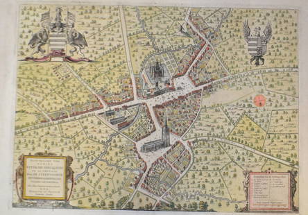
Sold201518th C French Map Of SteenvoordePLOUICH, Vedastus du -" Illvstrissimo viro domino" .The city of Steenvoorde is a small town located north of France. The city of Steenvoorde is located in the department of Nord of the french region.See Sold Price
Sold2021Pair 18th C French Maps after the AntiqueTo include "A View of the Town-House or Guild Hall of Paris" and "Vue de Chateau Royal D'amboise" : mid 20th century prints after the antique, housed in concave giltwood frames. Copperplate engravingsSee Sold Price
Sold201718th Century French Map of North AmericaL’Amerique Septentrionale. Daniel de la Feuille (1640-1709). Engraved map with hand color in full. Amsterdam, 1702 or 1706. 6 x 8 inches visible, 13 x 14 1/2 inches framed. Nicely colored early 18thSee Sold Price
Sold202118TH CENTURY FRENCH MAP OF SOUTHEASTERN USRigobert Bonne (French, 1727-1794). "Carte De la Partie Sud Des Etats Unis De L'Amerique Septentrionale" -circa 1780, engraving. Provenance: From the Lifetime Collection of Billy S. Arant, Jr., ChattaSee Sold Price
Sold2017Antique French Map and Plan of Boston, MassachusettsTitle/Content of Map: Antique French Map and Plan of Boston, Massachusetts Date Printed: 1757 Cartographer: Bellin, Jacques Nicolas Size (in): 10 x 6 One of the earliest obtainable town plans of BostoSee Sold Price
Sold2019.18th Century French Map of Cuba, Florida and Louisiana21 1/4 x 16 3/4 in. (framed).18th Century French Map of Cuba, Florida and LouisianaGulf of Mexico antique map Golfe du Mexique Zannoni 1762Title: Carte Geo-Hydrographique du Golfe du Mexique et de sesSee Sold Price
Sold202118TH CENTURY FRENCH MAP OF THE WORLDDimensions: Frame: H 14.5" x W 19.35" Sight: H 9.25" x W 13.75" Condition: Discolored old watercolor, some toning to mat.See Sold Price
Sold2020Group of French Maps Guillaume de l'Isle SansonGroup of four 17th and 18th century French maps. Guillaume Delisle (1675-1726) hand colored engraved map of Picardie, 1748. Two maps by Nicolas Sanson (1600-1677), "Le Roayaume de France" and "GouvernSee Sold Price
Sold2022GUILLAUME DE LISLE (1675-1726), AN 18TH CENTURY FRENCHGUILLAUME DE LISLE (1675-1726), AN 18TH CENTURY FRENCH COLONIAL MAP, "Carte de la Louisiane et de Cours du Mississipi," AMSTERDAM, CIRCA 1727, engraving on paper with ink inscriptions, after GuillaumeSee Sold Price
Sold2023Brion Map of East AsiaLouis Brion de la Tour, French, 1743-1803. An 18th century engraved map with hand-coloring, titled "Chine, et Indes avec les Isles". Signed "par M. Brion" and dated "1766" in the plate lower left. MinSee Sold Price
Sold202218TH C. MAP OF NEW ENGLAND"Map of the Northern or New England States of America, Comprehending Vermont, New Hampshire, District of Main (sic), Massachusetts, Rhode Island and Connecticut" by J. Russell. Extends south to includSee Sold Price
Sold202118TH C. MAP OF THE PERSIAN COAST, FRAMED"A Chart of the Coast of Persia, Guzarat & Malabar, drawn from the French Chart of ye Eastern Ocean, Publish'd in 1740, by Order of the Count de Maurepas, improved from particular Surveys and regulateSee Sold Price
Sold2022A Chinese Ge-glazed water coupe, 18th centuryA Chinese Ge-glazed water coupe 18th century H: 1 1/8, Dia: 3 in. (H: 2.86, Dia: 7.62 cm.) Provenance: Mr. Yiu, Boston, Massachusetts. Acquired in Hong Kong prior to 1990's.See Sold Price
Sold2017BOSTON, MASSACHUSETTS COIN SILVER PORRINGERBOSTON, MASSACHUSETTS COIN SILVER PORRINGER, with open-work handle, marked to underside of handle "BOYER" for Daniel Boyer, Boston, MA (1725-1779). Total weight: 9.27 ozt. Reserve. Mid 18th century. 5See Sold Price
Sold2015Map, Robert de VaugondyRobert de Vaugondy (French, 18th Century), "Partie Septentrionale La Couronne de Castille, ou se Trouvent les Royaumes de Castille Vieille de Leon, de Gallice des Asturies la Biscaye et la Navarre, enSee Sold Price
2 days LeftUniversity ArchivesRare 18th C. French Engraving Showing Chilean Hockey Player & Other Exotic CustomsUS$140
3 days LeftDuMouchellesFrench And American Louis XVI Period And Style Bleached Wood Armchairs, 18th & 20th C., H 40" WUS$150
4 days LeftPrime Auction Gallery, Inc.Late 18th C. French Louis Style XV Marquetry Bronze Mounted CommodeUS$1,700
4 days LeftAuction Plus, Inc.Set Of Four Late 18th C. French Hand Painted Jeweled & Enamel Sevres PlatesUS$4,000
5 days LeftBlackstone Valley Auctions & Estates LLCRevolutionary Era War Map of the Attack on Ft. Moultrie.US$225(3 bids)