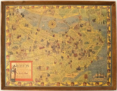
Sold20191950s Garfield Pictorial Map of Boston -- A Scott-MapTitle: 1950s Garfield Pictorial Map of Boston -- A Scott-Map of Boston Massachusetts Date: ca. 1950, Concord, MA Cartographer: A Scott Garfield Size: 20.7 x 27 in. Additional Information: A very attraSee Sold Price
Sold2021Boston Massachusetts Pictorial MapThe Colour of an Old City. Edwin Olsen and Blake Clark. Houghton Mifflin, Boston: 1926. Illustrated map. Ex library. 28 1/2" x 38".See Sold Price
Sold2023[NATIONAL PARKS] LINDGREN, Jolly (1895-1952). A Hysterical ...[NATIONAL PARKS] LINDGREN, Jolly (1895-1952). A Hysterical Map of Yellowstone Park and the Jackson Hole Country Slightly Cockeyed. Circa 1950s. Colorful and comical pictorial map of Yellowstone NationSee Sold Price
Sold2022(3) PICTORIAL MAPS OF US, CONN VALLEY & BOSTON1930s 22 x 30 approx (and smaller) Condition: Good to fairSee Sold Price
Sold2023Vintage, 'Shipwrecks of Boston Harbor" Pictorial Chart Map, 20th centuryVintage, "Shipwrecks of Boston Harbor" Pictorial Chart Map, 20th century, role call of 75 major wrecks. Overall 25.25 in. x 28.25 in.See Sold Price
Sold20191938 R Taylor White Pictorial Map of Minnesota --Title: 1938 R Taylor White Pictorial Map of Minnesota -- Minnesota Date: 1938, Boston Cartographer: Ruth Taylor White Size: 11.6 x 8.5 in. Additional Information: This is Ruth Taylor White's charmingSee Sold Price
Sold20191938 R Taylor White Pictorial Map of Oklahoma --Title: 1938 R Taylor White Pictorial Map of Oklahoma -- Oklahoma Date: 1938, Boston Cartographer: Ruth Taylor White Size: 11.6 x 8.5 in. Additional Information: This is Ruth Taylor White's charming piSee Sold Price
Sold2020Pictorial map of Dude Ranches of the WestHeading: (Sportsman's...) Author: Blakeman, T.G. Title: The Sportsman's Dude Ranch Map Place Published: Boston Publisher:The Sportsman Publishing Co. Date Published: 1934 Description: <See Sold Price
Sold2022RARE PICTORIAL MAP OF CAPE ANN & THE NORTH SHOREMounted to board. Designed by Errol W. Goff for Houghton Mifflin Co Boston MA 1934. 31 3/8 x 36 1/2 inches. Condition: Good. Frame slightly bowed.See Sold Price
Sold20201938 R Taylor White Pictorial Map of North Carolina --Title: 1938 R Taylor White Pictorial Map of North Carolina -- North Carolina Date: 1938, Boston Cartographer: Ruth Taylor White Size: 11.6 x 8.5 in. Additional Information: This is Ruth Taylor White'sSee Sold Price
Sold20181935 ArizonaBy: Ruth Taylor Date: 1935 (Published) Boston Dimensions: 11.5 x 8.5 inches (29.2 cm x 22.2 cm) This colorful pictorial map of Arizona was done in 1935 by Ruth Taylor. It appeared in the atlas publishSee Sold Price
Sold2024WWII LotWWII ephemera lot. Includes book "ON TARGET", book "THE 301st SUPPLY TRAIN IN THE WORLD WAR", folded map, "PICTORIAL HISTORY OF THE HARBOR DEFENSES of BOSTON" (1941), along with early German militarySee Sold Price
2016Book - Through Unexplored AsiaThrough Unexplored Asia . by Reid, William Jameson. Published by Dana Estes & Co., Boston; (1899). 499pp., illustrated, 3 folding maps in rear pocket, bound in burgundy pictorial cloth with accent colSee Sold Price
Sold2023THE HOBBIT by J.R.R. Tolkien. 27th Printing. Boston: Houghton Mifflin, 1966The Hobbit by J.R.R. Tolkien. 27th Printing. Boston: Houghton Mifflin, 1966. Original pictorial dust jacket. Original green cloth covered boards with titles to spine and front cover in dark blue. MapSee Sold Price
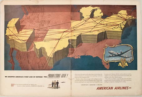
Sold20231950s American Airlines Route Map -- American Airlines Route MapTitle: 1950s American Airlines Route Map -- American Airlines Route Map Cartographer: American Airlines Year / Place: 1950s Map Dimension (in.): 12.5 X 19.2 in. joined This nice, large pictorial routeSee Sold Price
Sold2018Gleason’s Pictorial: View of Moro Castle, HavanaReserve Reduced! Map Title: View of Moro Castle. Cartographer: Gleason's Pictorial Drawing-Room Companion Place/Date: Boston / 1851 Size: 9" x 6 1/2" (image), 10" x 14 1/2" (overall, including image aSee Sold Price
Sold2022(PICTORIAL MAPS.) John Diakoff; G. Primakoff; and P. Sergeeff. Map of China.(PICTORIAL MAPS.) John Diakoff; G. Primakoff; and P. Sergeeff. Map of China. Enormous chromolithographed map of China with profuse pictorial illustration, inset charts, reference tables, and scenic viSee Sold Price
Sold2022(PICTORIAL MAPS.) Ignatz Sahula. Map of the 18th Annual Convention of the National Association of(PICTORIAL MAPS.) Ignatz Sahula. Map of the 18th Annual Convention of the National Association of Real Estate Boards. City of Detroit - June 23 to June 26 1925. Detroit is Yours Realtors! Large color-See Sold Price
Sold2023A Decorative Pictorial Map of The New York Worlds Fair by William L. Longyear (American, 1899-1980)A Decorative Pictorial Map of The New York Worlds Fair by William L. Longyear (American, 1899-1980). Framed. Designed and copyrighted by William Longyear. Lithographed in U.S.A by Polygraphic CompanySee Sold Price
Sold2021Pictorial Map of Nantucket by Austin StrongHand colored in original and great condition, professionally matted and framed, c. 1921, 14 H inches x 17 W inches sight, 23 H inches x 26 W inches, overall. Austin Strong (1881-1952)Austin Strong, stSee Sold Price
Sold2020Color pictorial map of Panama Mail Steam Ship routeHeading: (Panama Mail Steamship - color pictorial map) Author: Godwin, Harrison Title: The sea coastes of America shewing the ports of call of the Panama Mail Steamships as the country there aboutes iSee Sold Price
Sold2020Rare pictorial map of Peking 1936Heading: (China - Beijing) Author: Dorn, Frank Title: A Map and History of Peiping, formerly known as Peking... Place Published: Tienstsin-Peiping Publisher:Peiyang Press, Ltd. Date Published: </See Sold Price
Sold2022(PICTORIAL MAPS.) Charles Turzak & Henry Chapman. An Illustrated Map of Chicago • Youthful(PICTORIAL MAPS.) Charles Turzak & Henry Chapman. An Illustrated Map of Chicago • Youthful City of the Big Shoulders • Restless • Ingenious • Wilful • Violent • ProSee Sold Price
Sold2022Marvelous pictorial map of the WorldHeading: (Maps) Author: Ensign & Thayer Title: World at One View Place Published: New York Publisher: Date Published: 1847 Description: Lithographed double-hemisphere map of theSee Sold Price
Featured1 day LeftJasper52Hawaii & American Samoa. Pictorial state map by Ruth Taylor White 1935 oldUS$140
670 Lots AwayMynt AuctionsFebruary 1959 NHL Hockey Pictorial Magazine Doug Mohns Boston Bruins on CoverUS$10
Jun 26Eldred'sMAP OF BROOKLINE, MASSACHUSETTS, BELIEVED TO BE THE FIRST PUBLISHED MAP OF THE TOWN, Circa 1844 22"US$1,200
Jun 26Eldred'sMAP "PLAN OF THE TOWN OF BOSTON" Circa 1775 11.75" x 5.75" sight. Framed 16.5" x 9.5".US$150
Jul 06Case Antiques, Inc. Auctions & AppraisalsColton's Atlas of the World, 1856, in Two Volumes; plus Africa / Mahdist War MapUS$500
12 hrs LeftC & T Auctioneers and Valuers LtdTwo Sutcliffe tinplate clockwork model Bluebird Speedboats, 1950s£165(3 bids)
BonhamsSPEED (JOHN) AND WILLEM BLAEU Pictorial title-pages to Speed's 'Theatre of the Empire of Great B...£30(3 bids)
Jul 06Rafael Osona Auctions1907 George Walker Massachusetts Atlas Plate No. 10 Map of NantucketUS$300
Jul 06Rafael Osona AuctionsVintage Tilghman Packing Co. "Historical Map of the Maryland Eastern Shore", circa 1957US$100
BonhamsTHOREAU, HENRY DAVID. 1817-1862. Walden; Or, Life in the Woods. Boston: Ticknor and Fields, 1854.US$4,000
7 days LeftJasper52The Campaign Of The Jungle Edw. Stratemeyer Lothrop, Lee,Shepard Boston HC Rare!US$380
Jul 11Potter & Potter AuctionsCODY, William F. “Buffalo Bill” (1846-1917). Buffalo Bill’s...US$200
12 hrs LeftC & T Auctioneers and Valuers LtdThree boxed Sutcliffe tinplate clockwork model Submarines, 1950s/60s£100
Jun 27Forum AuctionsMiddle East.- Thesiger (Wilfred) Arabian Sands, first edition, signed by the author on title, 1959 &£100(1 bid)


![[NATIONAL PARKS] LINDGREN, Jolly (1895-1952). A Hysterical ...: [NATIONAL PARKS] LINDGREN, Jolly (1895-1952). A Hysterical Map of Yellowstone Park and the Jackson Hole Country Slightly Cockeyed. Circa 1950s. Colorful and comical pictorial map of Yellowstone Nation](https://p1.liveauctioneers.com/928/305275/163151881_1_x.jpg?height=310&quality=70&version=1697054833)