Sold2022RARE PICTORIAL MAP OF CAPE ANN & THE NORTH SHOREMounted to board. Designed by Errol W. Goff for Houghton Mifflin Co Boston MA 1934. 31 3/8 x 36 1/2 inches. Condition: Good. Frame slightly bowed.See Sold Price
Sold2020Rare pictorial map of Peking 1936Heading: (China - Beijing) Author: Dorn, Frank Title: A Map and History of Peiping, formerly known as Peking... Place Published: Tienstsin-Peiping Publisher:Peiyang Press, Ltd. Date Published: </See Sold Price
Sold2020Rare pictorial map of Oakland and S.F. BayHeading: (California - Oakland, San Francisco, etc.) Author: Lundy, Fred Title: San Francisco Bay. (with) part of San Francisco and Oakland Place Published: Oakland, CA Publisher:Tribune Publishing CoSee Sold Price
Sold2021Russell, William 1778 Rare Map. North Part of PeruCopper Engraved Map Published 1778, London for "The History of America, From Its Discovery by Columbus to the Conclusion of the Late War" by William Russell. Engraved by John Lodge. Rare. Paper Size:See Sold Price
Sold2020Small Hand-Colored Map of Nantucket by William SchontzeSmall Hand-Colored Map of Nantucket by William Schontzeler,rare pictorial map of Nantucket in original frame, signed, l.r William Cotton Schontzeler, trained as a draftsman in NY, he owned and workedSee Sold Price
Sold2021Melbourne Hardwick (1857-1916) MA Artist WatercolorTitle: Cape Ann Shore Medium: Watercolor on paper Style: Impressionist Size: 17" x 25" Frame Size: 22 1/2" x 30 1/2" Age: 1898 Condition: Good overall condition for its age, Very old gallery label onSee Sold Price
Sold2024Pictorial Map of Hollywood and Vicinity / Hollywood Film Ca...Pictorial Map of Hollywood and Vicinity / Hollywood Film Capital of the World. 1947. Los Angeles: Lowell E. Jones. Lithograph. Rare pictorial map of Hollywood with map of California on verso. PublisheSee Sold Price
Sold2021Rare pictorial tourist map of Imperial Valley, Cal.Heading: (California - Imperial Valley) Author: Pique, Ethel Title: Points of Interest in Imperial Valley, Land of Sunshine & Romance Place Published: El Centro, Calif. Publisher:El Centro Chamber ofSee Sold Price
Sold2018Signed Ernest Dudley Chase 1945 pictorial map of NorthTitle: A Pictorial Map of North America Map maker: Ernest Chase Dudley Place and Year: Winchester, 1945 Dimensions: 68.2 x 50.2 cm (26.9 x 19.8 in) Technique: Offset printing Coloring: Original printeSee Sold Price
Sold20201938 R Taylor White Pictorial Map of North Carolina --Title: 1938 R Taylor White Pictorial Map of North Carolina -- North Carolina Date: 1938, Boston Cartographer: Ruth Taylor White Size: 11.6 x 8.5 in. Additional Information: This is Ruth Taylor White'sSee Sold Price
Sold20211938 R Taylor White Pictorial Map of North Dakota --Title: 1938 R Taylor White Pictorial Map of North Dakota -- North Dakota Cartographer: Ruth Taylor White Year / Place: 1938, Boston Map Dimension (in.): 11.6 x 8.5 in. This is Ruth Taylor White's charSee Sold Price
Sold2023Geologic Map of Cape Ann Mass. Showing Superficial DepositsPublication Date: 1881 Title: Geologic Map of Cape Ann Mass. Showing Superficial Deposits Cartographer: SHALER, N. S. Publisher: U.S.G.S. Height: 10.25 Width: 10.25 From the Ninth Annual Report U.S. GSee Sold Price
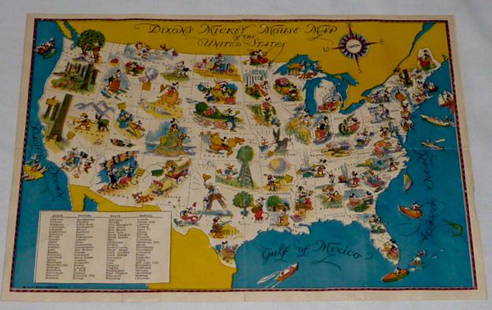
Sold2022Walt Disney Dixon's Mickey Mouse Map of United StatesEarly Disneyana collectible map. Copyright Walt Disney Enterprises 1935. Rare early pictorial map of the United States , richly illustrated with Disney character vignettes in each of the 48 states, MiSee Sold Price
Sold20181855 Colton Map of North Carolina -- Colton's NorthTitle/Content of Map: 1855 Colton Map of North Carolina -- Colton's North Carolina Date: 1855 New York Cartographer: J Colton Size: 12.9 X 16.4 in. An excellent and somewhat rare map of North CarolinaSee Sold Price
Sold2024Map of North America, Geographical Pub CoNorth America. Geographical Publishing Co., Animated North America, 1929 (circa). Printed Color. This pictorial map of North America is filled with illustrations demonstrating the continent's diverseSee Sold Price
Sold2022RARE GERMAN MAP OF NORTH AMERICARARE GERMAN MAP OF NORTH AMERICA: (1678-1757), [Accurata delineatio celeberrimae Regionis, Ludovicianae vel Gallice Louisiane...Septemtrionali America...Mississippi vel. St. Louis...], ''Matthaei SeutSee Sold Price
Sold2021RARE CYCLING MAP OF CAPE COD, NANTUCKET ISLAND ANDRARE CYCLING MAP OF CAPE COD, NANTUCKET ISLAND AND MARTHA'S VINEYARDMassachusetts, 1891Prepared for the "Mass. Div. of L.A.W. by W.T. Oliver, Lynn Mass". L.A.W. refers to the League of AmeriSee Sold Price
Sold2023Barclay, James C1800 Rare Hand Col Map. North AmericaRare impression with contemporary hand color. By uncommon Publishers Lawson's of Halifax. Hand Colored Copper Engraved Map Published C1800 Halifax & Newcastle, England for "Barclay's Universal EnglishSee Sold Price
Sold2015rare & important ca 1780 North Shore MA 3 tier mahograre & important ca 1780 North Shore MA 3 tier mahog dumb waiter - 40" tallSee Sold Price
Sold2017Rare 1967 Mouzon Map of North & South Carolinavery limited production by Louis and Clark Explorer Maps LLC in Kitty Hawk, and Charlotte, North Carolina. reproduction gives excellent detail and very well resembles the original map. marked "L&C" atSee Sold Price
Sold2022Barclay, James C1800 Hand Col Map. North America. RareRare impression with contemporary hand color. By uncommon Publishers Lawson's of Halifax. Hand Colored Copper Engraved Map Published C1800 Halifax & Newcastle, England for "Barclay's Universal EnglishSee Sold Price
Sold2017Early 1900's Pittsburgh North Shore Plot Map AlleghenyPittsburgh North Shore Plot Map Allegheny City, Volume 1, Plate 1, circa early 1900's, print on paper with colored additions, 18.5 x 26.25, black matte frame: 26 x 34.25 x 0.75 inchesSee Sold Price
Sold2022Post Card AlbumPost card album containing aproximately 142 cards from Massachusetts including Cape Cod, Nantucket, and North Shore MASee Sold Price
Sold2018North Sea countries. Rare Map of Scandanavia. BritishNorth Sea countries. Rare Map of Scandanavia. British isles to Greenland 1740-70's J.N. Bellin & J.F. La Harpe 14 1/2" x 19 1/3" Copperplate engraved. Published in Paris. From the 'Aberge de L'HistoirSee Sold Price
6 days LeftTrillium Antique Prints & Rare BooksKarl Bodmer - Bellvue, MR. Dougherty's Agency on the Missouri. 31US$300
Jun 08Leon GalleryJodocus Hondius 1606 (Jodocus Hondius and Cornelis Claesz) - India Orientalis₱40,000
Featured2 days LeftJasper521630 Mercator Map of Bermuda -- Mappa Aestivarum Insularum Alias Bermudas Dictarum ad Ostia MexicaneUS$320
3 days LeftJasper52Extremité Meridionale de l'Amérique Tierra del Fuego Magellan Str BONNE 1788 mapUS$35
2 days LeftJasper521593 de Jode Maps of Eastern Germany (Saxony Area) and Western Germany -- Mansfeldiae Comitatus ...US$700
6 days LeftTrillium Antique Prints & Rare BooksKohler & Weigel - Map of the World with North and South Pole viewsUS$75(1 bid)
6 days LeftTrillium Antique Prints & Rare BooksSanson - Map of Florida (encompassing most of Southeast North America)US$75(1 bid)


![RARE GERMAN MAP OF NORTH AMERICA: RARE GERMAN MAP OF NORTH AMERICA: (1678-1757), [Accurata delineatio celeberrimae Regionis, Ludovicianae vel Gallice Louisiane...Septemtrionali America...Mississippi vel. St. Louis...], ''Matthaei Seut](https://p1.liveauctioneers.com/196/260293/135583412_1_x.jpg?height=310&quality=70&version=1662057165)


