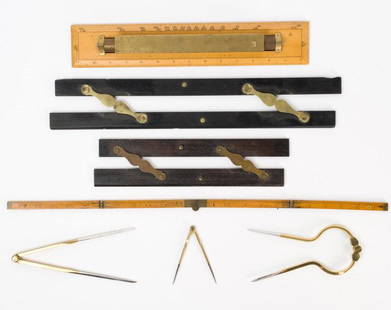
Sold2021Antique & Vintage Marine Map Chart AccessoriesA group of six very good marine map chart accessories, consisting of: two antique ebony & brass parallel rules - the 12" rule stamped THREADWELL LONDON, the 18" rule with minor chips, a 15" antique brSee Sold Price
Sold2023L'Africa. DE ROSSI / SANSON 1677 old antique vintage map plan chartTITLE/CONTENT OF MAP: L'Africa [Africa] DATE PRINTED: 1677 IMAGE SIZE: Approx 42.5 x 57.0cm, 16.75 x 22.25 inches (Large) TYPE: Antique 17th century folio atlas map CONDITION: Good; suitable for framiSee Sold Price
Sold2024L'Europa. Europe. DE ROSSI 1677 old antique vintage map plan chartTITLE/CONTENT OF MAP: L'Europa [Europe] DATE PRINTED: 1677 IMAGE SIZE: Approx 44.0 x 56.5cm, 17.25 x 22.25 inches (Large) TYPE: Antique 17th century folio atlas map CONDITION: Good; suitable for framiSee Sold Price
Sold2023L'Europe. Europe. BONNE 1780 old antique vintage map plan chartTITLE/CONTENT OF MAP: 'L'Europe' A map of Europe DATE PRINTED: 1780 IMAGE SIZE: Approx 23.0 x 34.0cm, 9 x 13.5 inches (Large); Please note that this is a folding map. TYPE: Antique copperplate engraveSee Sold Price
2022Havana. Cuba 1885 old antique vintage map plan chartTITLE/CONTENT OF MAP: 'Havana' DATE PRINTED: 1885 IMAGE SIZE: Approx 22.5 x 29.0cm, 8.75 x 11.25 inches (Large); Please note that this is a folding map. TYPE: Antique colour map; Scale 1:14,000 CONDITSee Sold Price
Sold2023HOLY ROMAN EMPIRE. Europe in 1360 1902 old antique vintage map plan chartTITLE/CONTENT OF MAP: 'Europe in 1360' DATE PRINTED: 1902 IMAGE SIZE: Approx 25.0 x 33.5cm, 10 x 13.25 inches (Large) TYPE: Antique colour map. This map was published in 1902 but it may depict an earlSee Sold Price
Sold2024Europe by Arrowsmith & Lewis 1812 old antique vintage map plan chartTITLE/CONTENT OF MAP: 'Europe' DATE PRINTED: 1812 IMAGE SIZE: Approx 25.0 x 20.0cm, 9.75 x 8 inches (Medium) TYPE: Antique steel engraved map CONDITION: Good; suitable for framing. Please check the scSee Sold Price
Sold2022Western division of Cuba 1885 old antique vintage map plan chartTITLE/CONTENT OF MAP: 'Western division of Cuba' DATE PRINTED: 1885 IMAGE SIZE: Approx 13.0 x 11.5cm, 5 x 4.5 inches (Small) TYPE: Antique wood-engraved map; Scale 1:6,000,000 CONDITION: Good; suitablSee Sold Price
Sold2023AFRICA. Africa. Britannica 9th edition 1898 old antique vintage map plan chartTITLE/CONTENT OF MAP: 'Africa' DATE PRINTED: 1898 IMAGE SIZE: Approx 26.0 x 32.5cm, 10.25 x 12.75 inches (Large); Please note that this is a folding map. TYPE: Antique coloured map CONDITION: Good; suSee Sold Price
Sold2024Isothermals of the Pacific Ocean 1886 old antique vintage map plan chartTITLE/CONTENT OF MAP: 'Isothermals of the Pacific' DATE PRINTED: 1886 IMAGE SIZE: Approx 19.0 x 26.5cm, 7.5 x 10.5 inches (Medium); Please note that this is a folding map. TYPE: Antique engraved colouSee Sold Price
Sold2024North East Africa 1885 old antique vintage map plan chartTITLE/CONTENT OF MAP: 'North East Africa' DATE PRINTED: 1885 IMAGE SIZE: Approx 31.5 x 23.0cm, 12.5 x 9 inches (Large); Please note that this is a folding map. TYPE: Antique colour map CONDITION: GoodSee Sold Price
Sold2023Isothermal lines of South America 1885 old antique vintage map plan chartTitle: Isothermal lines of South America 1885 old antique vintage map plan chart Description: Isothermal lines of South America' by Engraved for Élisée Reclus (1885). Antique wood-engraved mSee Sold Price
Sold2023SOUTH AMERICA. Britannica 9th edition 1898 old antique vintage map plan chartTitle: SOUTH AMERICA. Britannica 9th edition 1898 old antique vintage map plan chart Description: South America' by Britannica, Encyclopaedia (1898). Antique coloured map, 32.5 x 25.0cm, 12.75 x 9.75See Sold Price
Sold2022American Isthmuses. Caribbean 1885 old antique vintage map plan chartTITLE/CONTENT OF MAP: 'American Isthmuses' DATE PRINTED: 1885 IMAGE SIZE: Approx 9.0 x 11.5cm, 3.5 x 4.5 inches (Small) TYPE: Antique wood-engraved map; Scale 155;000;000 CONDITION: Good; suitable forSee Sold Price
Sold2024ASIA (Relief) 1907 old antique vintage map plan chartCAPTION PRINTED BELOW PICTURE: 'ASIA (Relief)' DATE PRINTED: 1907 IMAGE SIZE: Approx 17.5 x 22.5cm, 7 x 8.75 inches (Medium) TYPE: Antique map CONDITION: Good; suitable for framing. Please check the sSee Sold Price
Sold2024World War 2. Planned expansion of Japanese Empire 1959 old vintage map chartCAPTION PRINTED BELOW PICTURE: 'The War with Japan - Contemplated Expansion of Japanese Empire' DATE PRINTED: 1959 IMAGE SIZE: Approx 25.0 x 32.0cm, 9.75 x 12.75 inches (Large) TYPE: Antique colour miSee Sold Price
Sold2018Brass Chart Map Glass Magnifying Desk Lens Magnifier w4" Vintage Antique Style Solid Brass Heavy Glass Magnifying Desk Lens Magnifier Description Glass is 1 7/8" Wide x 2" High,.. adjustable to 2 1/2" box is 2 3/4" x 2 3/4" x 2 3/4" Nice reproduction ofSee Sold Price
Sold2018Brass Chart Map Glass Magnifying Desk Lens Magnifier w4" Vintage Antique Style Solid Brass Heavy Glass Magnifying Desk Lens Magnifier Glass is 1 7/8" Wide x 2" High,.. adjustable to 2 1/2" box is 2 3/4" x 2 3/4" x 2 3/4" Nice reproduction of an antique mSee Sold Price
Sold2018Brass Chart Map Glass Magnifying Desk Lens Magnifier w4" Vintage Antique Style Solid Brass Heavy Glass Magnifying Desk Lens Magnifier Description Glass is 1 7/8" Wide x 2" High,.. adjustabSee Sold Price
Sold2018Brass Chart Map Glass Magnifying Desk Lens Magnifier w4" Vintage Antique Style Solid Brass Heavy Glass Magnifying Desk Lens Magnifier Glass is 1 7/8" Wide x 2" High,.. adjustable to 2 1/2" box is 2 3/4" x 2 3/4" x 2 3/4" Nice reproduction of an antique mSee Sold Price
Sold2018Brass Chart Map Glass Magnifying Desk Lens Magnifier w4" Vintage Antique Style Solid Brass Heavy Glass Magnifying Desk Lens Magnifier Description Glass is 1 7/8" Wide x 2" High,.. adjustable to 2 1/2" box is 2 3/4" x 2 3/4" x 2 3/4" Nice reproduction ofSee Sold Price
Sold2018Brass Chart Map Glass Magnifying Desk Lens Magnifier w4" Vintage Antique Style Solid Brass Heavy Glass Magnifying Desk Lens Magnifier Description Glass is 1 7/8" Wide x 2" High,.. adjustable to 2 1/2" box is 2 3/4" x 2 3/4" x 2 3/4" Nice reproduction ofSee Sold Price
Sold2018Brass Chart Map Glass Magnifying Desk Lens Magnifier w4" Vintage Antique Style Solid Brass Heavy Glass Magnifying Desk Lens Magnifier Description Glass is 1 7/8" Wide x 2" High,.. adjustabSee Sold Price
Sold2024Isothermal Lines of Africa. Sketch map 1885 old antique vintage plan chartTITLE/CONTENT OF MAP: 'Isothermal Lines of Africa' DATE PRINTED: 1885 IMAGE SIZE: Approx 13.5 x 12.0cm, 5.25 x 4.75 inches (Small) TYPE: Antique engraved sketch map CONDITION: Good; suitable for framiSee Sold Price
2 days LeftJasper52Holland and Belgium. Luxembourg. Benelux. SWANSTON 1860 old antique map chartUS$20
2 days LeftJasper52Europe from the best authorities by Richard Brookes 1812 old antique map chartUS$30
2 days LeftJasper52Carte d'Assemblage de l'Europe. VANDERMAELEN 1827 old antique map plan chart TITLE/CONTENT OF MAP:US$40
2 days LeftJasper52Scandinavia Russia sea chart. Ports lighthouses. Arctic Ocean Bothnia 1918 mapUS$20
2 days LeftJasper52Scandinavia Russia sea chart. Ports lighthouses. Arctic Ocean Bothnia 1916 mapUS$20
2 days LeftJasper52Eastern Europe sea chart Ports Lighthouses mail route Black Sea Baltic 1916 mapUS$40
2 days LeftJasper52North Sea sea chart. Ports lighthouses mail routes. UK Norway &c LARGE 1952 mapUS$40


![L'Africa. DE ROSSI / SANSON 1677 old antique vintage map plan chart: TITLE/CONTENT OF MAP: L'Africa [Africa] DATE PRINTED: 1677 IMAGE SIZE: Approx 42.5 x 57.0cm, 16.75 x 22.25 inches (Large) TYPE: Antique 17th century folio atlas map CONDITION: Good; suitable for frami](https://p1.liveauctioneers.com/5584/308981/165185503_1_x.jpg?height=310&quality=70&version=1699996168)
![L'Europa. Europe. DE ROSSI 1677 old antique vintage map plan chart: TITLE/CONTENT OF MAP: L'Europa [Europe] DATE PRINTED: 1677 IMAGE SIZE: Approx 44.0 x 56.5cm, 17.25 x 22.25 inches (Large) TYPE: Antique 17th century folio atlas map CONDITION: Good; suitable for frami](https://p1.liveauctioneers.com/5584/322790/173578184_1_x.jpg?height=310&quality=70&version=1710881198)


