Sold2023Antique Map Print - Map of Africa - Madagascar - Nil - Sahara - KilimanjaroTitle: Antique Map Print - Map of Africa - Madagascar - Nil - Sahara - Kilimanjaro Date/Period: 1701 Dimensions: 6” x 5” inches / 15 cm x 13 cm Material: Paper Additional Information: A deSee Sold Price
Sold2022Antique Map Print - Map of Africa - The Royal Atlas - Kate JohnstonMap of Africa. Kate Johnston, F.R.S.E. Engraved and printed by W. & A.K. Johnston. Prime meridian: Greenwich; Relief shown by dashes. Top left: "Keith Johnston's General Atlas." Separated from Keith JSee Sold Price
Sold2022Antique Map Print - South Africa - Algeria - Egypt - PalestineSet of 4 Map Prints. Antique lithographic map originates from "Letts's Popular Atlas", being a series of maps delineating the whole surface of the globe, with many special and original features; and aSee Sold Price
Sold2022Antique Map Print - North America - Africa - South America - WorldSet of 4 Map Prints. Hand-colored map print of the edition of 1851 from the work Universal Historical and Geographical Atlas ("Atlas Universel Historique et Geographique"). This iconic map contains diSee Sold Price
Sold2022Antique Map of Africa - Morocco - Madagascar - Angola - Zimbabwe - UgandaAntique map of Africa by Becker, published in London, c 1860. This antique map was engraved by the omnigraph method by Francis Paul Becker & Company, Patentees circa 1842, with contemporary hand colouSee Sold Price
Sold2023Reclus, Elisee C1880 Mixed Lot of 15 Antique MapsIncl Asia, Africa, Madagascar, and Switzerland. Lithograph Maps Published 1876-94, London for "The Universal Geography" by Elisee Reclus. Edited by A. H. Keane. Centre fold as issued. Paper Size: MostSee Sold Price
Sold2024Bonne & Desmarest - Map of AfricaThis fine map engraving is from Rigobert Bonne and Nicolas Desmarest's Atlas encyclop?dique, contenant la g?ographie ancienne, et quelques cartes sur la g?ographie du moyen age, la g?ographie moderneSee Sold Price
Sold2023Ptolemy, Fries, pub. 1535 - Map of Northern Africa and EgyptThis important historic map is from Geographicae enarrationis libri octo Ex Bilibaldi Pirckeymheri tralatione, fed ad Graeca & prisca exemplaria.... The work was published in 1535 in Lyon after LorenzSee Sold Price
Sold2024Africa. Tribes/pre-European Kingdoms. Great Lakes & Nile. BARTHOLOMEW 1862 mapTITLE OF PRINT (NOT PRINTED ON THE PAGE):'Africa' DATE PRINTED: 1862 IMAGE SIZE: Approx 56.5 x 44.0cm, 22.25 x 17.25 inches (Large); Please note that this is a folding map. TYPE: Antique coloured atlaSee Sold Price
Sold2023Duval - Map of the Mediterranean Sea with Surrounding borders of Europe, Asia, and AfricaThis fascinating map is from Pierre Duval. It was part of a composite or collector's atlas of his maps. It was done in Paris circa 1670s. The composite atlas originally included maps from the followinSee Sold Price
Sold2020Eight Drawer Oak Map, Art or Print File Cabinet, C 1910An antique map, art or print fining cabinet offers oak construction with eight drawers, brass pulls throughout, c1910. Measures- 45.5" H x 28" W x 22.75" D. ***IN-HOUSE SHIPPING & DELIVERY QUICK QUOTESee Sold Price
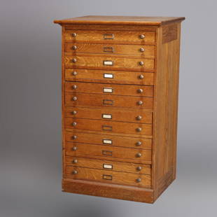
Sold2020Early Antique Oak 60- Drawer Type-Setting Print CabinetAn early antique type-setting, map or print cabinet offers paneled oak construction with 60 drawers, c1900.Measures- 53.5" H x 49" W x 21" D. ***IN-HOUSE SHIPPING & DELIVERY QUICK QUOTES AVAILABLE UPOSee Sold Price
Sold2018Oversized Industrial Commercial Oak Map Print CheOversized Industrial Commercial Oak Map Print Chest. Metal handles, panel sides. Antique.-- Dimensions: H: 65.5 inches: W: 63 inches: D: 25 inches ---See Sold Price
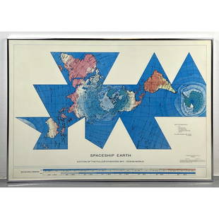
Sold2023Richard Buckminster Fuller Dymaxion World Map Print, 1980 FullerRichard Buckminster Fuller Dymaxion World Map Print, 1980 Fuller Dimensions: H: 22.5 inches: W: 34.5 inches --- -- We offer curbside delivery to NYC, Manhattan, Close Brooklyn, Hoboken about a week afSee Sold Price
Sold2017ANTIQUE MAP OF AFRICA, GERHARD MERCATOR JR.17TH CFramed engraved hand colored map, after 1600, by Gerhard Mercator Jr (his grandfather was Gerhard Mercator, Flemish, 1512-1594), "Africa Ex magna orbis terre descriptione Gerardi Mercatoris desumpta,See Sold Price
Sold20211588 Africae Tabula NovaBy: Abraham OrteliusDate: 1588 (published) AntwerpDimensions: 14.5 x 18 inches (36.83 x 45.72 cm)This is an authentic antique map of Africa was published by Abraham Ortellius in 1588. It was taken froSee Sold Price
Sold2018Ortelius: Antique Map of Ethipoia & East Africa, 1592Title/Content of Map: Ethipoia & East Africa. The Prester John Map by Ortelius Date Printed: 1592 Cartographer: Abraham Ortelius Material/Medium: Paper Size: 16" x 21" Hand colored copperplate engraveSee Sold Price
Sold2024Matthaus Merian 1627 Antique Map Engraving "Virginia" from Theodore de Bry's "Grand Voyages" #1Antique 1627 map of Virginia by Matthaus Merian after John Smith's 1612 map, from Theodore de Bry's "Grand Voyages". Please see "The Philidelphia Print Shop" sheet shown in final photo. Good conditionSee Sold Price
Sold2023Collection of Antique Prints "Cities of the World"Antique prints and etchings depicting "Cities of the World" - including Harper's Weekly illustrations, landscapes, antique maps, depictions of notable landmarks and famous cities such as Paris, New YoSee Sold Price
Sold2023Assorted Antique Greco-Roman Prints & EngravingsAntique 18th-20th Century Greco-Roman prints and engravings, including Classical depictions of figures and architecture; antique maps; arts and design; anatomical drawings; and more. Approximately 75See Sold Price
Sold2019Huge/clean 1867 wall map of North America, J. T. LloydHuge antique wall map in rare condition...varnish appears nearly fresh with absolutely no cracking. Includes original rollers which are also in great condition. Great hand-coloring and strong print. TSee Sold Price
Sold2017Lot of 6 Antique Celestial MapsLot of 6 Antique Celestial Maps. Inscribed "Drawn by W. Newton - W. Clarke Arch." These prints are further inscribed "Edward Stanford - London (publisher)". Dated "Noanno 1830". They remain in very niSee Sold Price
Sold2020Africa.- Ortelius (Abraham) Africae Tabula Nova, [c.Africa.- Ortelius (Abraham) Africae Tabula Nova, map of the African continent, with Madagascar and part of the Arabian Gulf, Zanzibar is shown on the west coast, decorated with a large strapwork titleSee Sold Price
Sold2023Seutter - Map of North America including Great Lakes, Florida, Virginia, New England, Mexico, WestThis engraving is from a composite atlas presented by the Homann Heirs. Many of the maps in the collection were completed by J. B. Homann, Homann Erben, M. Seutter, and T. C. Lotter. The maps were oriSee Sold Price
2 days LeftTrillium Antique Prints & Rare BooksPrevost - Map of Japan with part of Korea and ChinaUS$50
2 days LeftTrillium Antique Prints & Rare BooksPrevost - Map of the South Pacific Ocean with New Holland (Australia), New Zealand, and part of theUS$50(1 bid)
2 days LeftTrillium Antique Prints & Rare BooksPrevost - Map of the Philippines, Celebes, MoluccasUS$50
2 days LeftTrillium Antique Prints & Rare BooksPrevost - Pair of Engravings of Views of Acapulco, MexicoUS$50
2 days LeftTrillium Antique Prints & Rare BooksPrevost - Chart of the Bay of Bengal, Indian OceanUS$50
2 days LeftTrillium Antique Prints & Rare BooksGoltzius - 6 Etchings of Portraits of Holy Roman EmperorsUS$100