Sold2023Ptolemy, Fries, pub. 1535 - Map of Northern Africa and EgyptThis important historic map is from Geographicae enarrationis libri octo Ex Bilibaldi Pirckeymheri tralatione, fed ad Graeca & prisca exemplaria.... The work was published in 1535 in Lyon after LorenzSee Sold Price
Sold2023Ptolemy, Fries, pub. 1535 - Map of TurkeyThis important historic map is from Geographicae enarrationis libri octo Ex Bilibaldi Pirckeymheri tralatione, fed ad Graeca & prisca exemplaria.... The work was published in 1535 in Lyon after LorenzSee Sold Price
Sold2020Philip, George C1900 Lot of 5 Maps of AfricaIncl Northern Africa, Egypt and the Valley of the Nile, Central Africa, Africa and South of the Zambesi, and South Africa. Lithograph Maps Published C1900, London for "Philips' New Handy General AtlasSee Sold Price
Sold2023Plolemy- Map of AfricaC. Ptolemy/ M. Wallseemuller/L. Fries Ptolemaic Africa Vienne in-the-Dauphane,1541 Frame 26.5x21 Inset 18.5x13See Sold Price
Sold2019Bartholomew, John 1922 Mixed Lot of 9 Large MapsIncl Persia, South Atlantic, Northern Russia/Finland, Southern Scandinavia/Denmark, Baltic States/East Prussia, Switzerland, Lower Egypt, West Africa, Northern Africa, and Persia. Large Lithograph MapSee Sold Price
Sold2020Brockhaus (Pub) 1890's Lot of 5 Maps of AfricaAfrica continent, Egypt and Equatorial Africa. Lithograph Maps 1892-98 by F. A. Brockhaus, Leipzig for "Brockhaus' Konversations-Lexikon" by Various. Centre fold as issued. Paper Size: 12 x 10 inch (3See Sold Price
Sold2021Brockhaus (Pub) 1890's Lot of 6 Maps of AfricaIncl German East Africa, Egypt, Equatorial Africa and Political, Ethnographic and Physical Maps of the African Continent. Lithograph Maps Published 1892-98 by F. A. Brockhaus, Leipzig for "Brockhaus'See Sold Price
Sold20241950s Egyptian Necklace w/ Silver & Emerald BeadsNorthern Africa, Egypt, ca. 1950s CE. A fine necklace of wearable form strung with barrel-shaped nickel silver beads as well as dozens of hand-carved emeralds from Egypt. The green and steely gray hueSee Sold Price
Sold2023World: Ptolemy, pub. 1562 - Map of the Ancient WorldThis early map engraving is Joseph Moleti (Giseppi Moleti [Moletius])'s edition of Claudius Ptolemaeus (Ptolemy)'s Geographia. This is the first Moleti Latin edition of the work and was published by VSee Sold Price
Sold20191579 Ortelius Map of Northern Africa -- Barbariae etReserve Reduced! Map Title/Content: 1579 Ortelius Map of Northern Africa -- Barbariae et Biledulgerid, Nova Descriptio Cartographer: A Ortelius Year / Place: 1579, Antwerp Map Dimension (in.): 12.9 XSee Sold Price
Sold2022(AFRICA.) Abraham Ortelius. Two double-page engraved maps of northern Africa in original hand-color.(AFRICA.) Abraham Ortelius. Two double-page engraved maps of northern Africa in original hand-color. Antwerp, 1603 - Fessae, et Marocchi Regna Africae Celeberr. (Canary Islands, Morocco, Straits of GiSee Sold Price
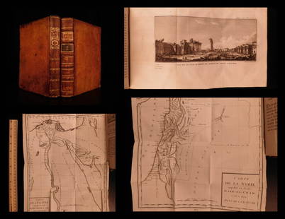
Sold20191799 Voyages in Syria & EGYPT Africa Illustrated MAPS1799 Voyages in Syria & EGYPT Africa Illustrated MAPS Sphinx Pyramids 2v Volney Constantin-François Volney, an 18th-century French philosopher known for his historical works on archaeology and travelSee Sold Price
Sold2022HAWES. BEA International Air Routes. 1954. GeorgeHAWES. BEA International Air Routes. 1954. George Philip & Son, Ltd. Second edition. Color offset pictorial system map of Europe and Northern Africa, showing BEA and affiliate routes (Aer Lingus, AlitSee Sold Price
Sold20201787 1st ed Voyages in Syria & EGYPT Africa Illustrated1787 1st ed Voyages in Syria & EGYPT Africa Illustrated MAPS Sphinx 2v Volney “The best expose of Ottoman Empire at the end of the 18th-century!” (Blackmer) Constantin-François Volney, an 18th-ceSee Sold Price
Sold2024Ptolemy & Magini, pub. 1620 - Double Hemisphere Map of the WorldThis early map engraving is from Claudius Ptolemaeus (Ptolemy) and Giovanni Antonio Magini's Geografia cio? Descrittione Universale della Terra Partita in due volumni, Nel Primo de' quali si contengonSee Sold Price
Sold20241849 Mitchell School ATLAS 24 MAPS America Holy Land France Africa Egypt Asia1849 Mitchell School ATLAS 24 MAPS America Holy Land France Africa Egypt Asia The name Mitchell has long been synonymous with 19th-century maps; in fact, Mitchell maps are often considered the best ofSee Sold Price
Sold202216th C. Woodcut Ptolemy Maps by Lorenz Fries (4)**Originally Listed At $800** Lorenz (Laurent) Fries (ca. 1485-1532). Published in Geographia of Claudius Ptolemy (Claudius Ptolemaeus, after 83-ca. 168 CE), 1541. Four Ptolemaic maps, all woodblocksSee Sold Price
Sold2018Map of Palestine - Woodcut - Lyon, 1535Tabula Terre Sanctae. Map of Palestine. Woodcut from "Geographia" by Ptolemy Claudius, edited by Michael Servetus. [Lyon, 1535]. Map of Palestine, showing the territories of the Tribes of Israel. TheSee Sold Price
Sold2022ABRAHAM ORTELIUS, ROMAN IMPERIL IMAGO, 1598, MAPCopper engraving, map of the Roman Empire Centered on the Mediterranean, depicting most of Europe, Northern Africa, with the Near and Middle East, published, Antwerp, Theatrum Orbis Terrarum. ContainiSee Sold Price
Sold2024MAP, Corsica, PtolemyCorsica, Sardinia & Sicily. Ptolemy/Fries, Tabula Nova Siciliae, Sardiniae, & Corsicae, from Claudii Ptolemaei Alexandrini Geographicae…, 1541 (published). Hand Color. This crisply engraved PtolemaiSee Sold Price
Sold2018LYON, George Francis 91795-1832). A Narrative ofLYON, George Francis (1795-1832). A Narrative of Travels in Northern Africa, in the years 1818, 19, and 20. London: John Murray, 1821. 4to (268 x 211 mm). Engraved folding map (old small paper repairSee Sold Price
Sold2018Europe.- Roman Empire.- Ortelius (Abraham) RomaniEurope.- Roman Empire.- Ortelius (Abraham) Romani Imperii Imago, map of the Roman Empire centered on the Mediterranean and covering most of Europe, Northern Africa, and the Near and Middle East, withSee Sold Price
Sold2018Europe.- Roman Empire.- Ortelius (Abraham) RomaniEurope.- Roman Empire.- Ortelius (Abraham) Romani Imperii Imago, map of the Roman Empire centered on the Mediterranean and covering most of Europe, Northern Africa, and the Near and Middle East, withSee Sold Price
Sold2022Africa.- Fries (Lorenz) [Tabula Nova Partis Africae], woodcut map, [c. 1525].Africa.- Fries (Lorenz) [Tabula Nova Partis Africae], rare Ptolemaic map of Southern Africa, a reduced version of Waldseemuller's map of 1513, from 'Claudii Ptolemaei Geographicae...', woodcut with fuSee Sold Price
1 day LeftTrillium Antique Prints & Rare BooksPtolemy & Magini, pub. 1620 - Map of the British Isles (Britain, Scotland, Ireland)US$50
1 day LeftTrillium Antique Prints & Rare BooksPtolemy & Magini, pub. 1620 - Map of Tuscany, ItalyUS$50
1 day LeftTrillium Antique Prints & Rare BooksPtolemy & Magini, pub. 1620 - 4 Maps of Parts of AsiaUS$50
5 days LeftJasper521730 Covens & Mortier Map of North Coast of Africa and Southern Europe -- In Notitiam EcclesiasticamUS$80
3 days LeftSchilb Antiquarian Rare Books1859 AFRICA VOYAGES Barth Timbuktu Tripoli SLAVES Illustrated Slavery MAP AfricanUS$105(5 bids)
May 17Albion AuctionsNat. Encyclo. 1890's Pair of Celestial Maps. Northern & Southern ConstellationsUS$10(2 bids)
Featured5 days LeftJasper521716 Homann Map of Northern Germany -- Circulus Saxoniae Inferioris in omnes suos Status etUS$95
1 day LeftTrillium Antique Prints & Rare BooksBonne - Pair of Maps (Eastern & Northern Hemisphere)US$75
6 days LeftPotter & Potter AuctionsAUDIBERTI, J. Choain. Afrique Equatoriale Francaise. Paris:...US$100(1 bid)
May 21BonhamsThe War in India: Despatches of the Rt. Hon. Lt. General Viscount Hardinge, Governor-General of ...£1,200


![World: Ptolemy, pub. 1562 - Map of the Ancient World: This early map engraving is Joseph Moleti (Giseppi Moleti [Moletius])'s edition of Claudius Ptolemaeus (Ptolemy)'s Geographia. This is the first Moleti Latin edition of the work and was published by V](https://p1.liveauctioneers.com/6581/307341/164260812_1_x.jpg?height=310&quality=70&version=1698409008)


![Map of Palestine - Woodcut - Lyon, 1535: Tabula Terre Sanctae. Map of Palestine. Woodcut from "Geographia" by Ptolemy Claudius, edited by Michael Servetus. [Lyon, 1535]. Map of Palestine, showing the territories of the Tribes of Israel. The](https://p1.liveauctioneers.com/1980/117218/60259208_1_x.jpg?height=310&quality=70&version=1520155929)


![Africa.- Fries (Lorenz) [Tabula Nova Partis Africae], woodcut map, [c. 1525].: Africa.- Fries (Lorenz) [Tabula Nova Partis Africae], rare Ptolemaic map of Southern Africa, a reduced version of Waldseemuller's map of 1513, from 'Claudii Ptolemaei Geographicae...', woodcut with fu](https://p1.liveauctioneers.com/5458/260724/135800393_1_x.jpg?height=310&quality=70&version=1662479034)


