Sold2020Land Ho! Antique Fishers Island Sound, RI-CT-NY USCGDescription: Ahoy! Antique Coast Guard nautical chart of Fishers Island Sound, RI-CT-NY. Numbered C. & G. S. 358; published 1968. Material: paper. Measurement: approximate 36" x 45" (INCHES). ShippingSee Sold Price
Sold2019Land Ho! Antique Western L.I. Sound, CT U.S. CoastDescription: Ahoy! Antique Coast Guard nautical chart of the L.I. Sound. Numbered C. & G. S. 1213; printed in 1968. Material: paper. Measurement: approximate 34" x 40" (INCHES). Shipping cost: $10; diSee Sold Price
Sold2019Land Ho! Antique Narragansett Bay, RI and MA U.S. CoastDescription: Ahoy! Antique Coast Guard nautical chart of the Narragansett Bay. Numbered C. & G. S. 353; with corrections from the Coast Guard denoted in purple. Material: paper. Measurement: approximaSee Sold Price
Sold2019Land Ho! Antique Block Island Sound, RI USCGDescription: Ahoy! Antique U.S. Coast Guard nautical chart of Block Island Sound and Approaches. Numbered C. & G. S. 1211; published 1968. Material: paper. Measurement: approximate 36" x 41" (INCHES).See Sold Price
Sold2017Antique Nautical Chart of West Mediterranean SeaMap: Old nautical chart of the west Mediterranean Sea Subtitle: Mediterranean Sea, Gibraltar to Alicante, Cape Spartel to Cape Ferrat from Spanish and French Government Charts to 1877. Creator: BritisSee Sold Price
Sold2017Jefferys: Antique Sea Chart Map of Coast of France 1774Map: 4th Chart of the Coast of France from Callais to Fecamp Date Printed: 1774 Cartographer: Jefferys, Thomas Size: 8 x 11 Condition: Very good Uniformly browned chain-laid paper. Strong impression.See Sold Price
Sold2020Nautical Map / Sea Chart, #224 Oyster & Huntington BaysUnited States East Coast, New York, Oyster & Huntington Bays, South Shore of Long Island Sound, 3rd edition feb 1/43; revised 7/21/58, note heavier bond paper and or better preserved than most; FoldedSee Sold Price
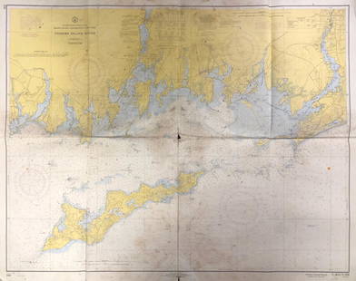
Sold2020Nautical Map / Sea Chart, #1212 Eastern Long IslandDescription: Nautical Map / Sea Chart, United States East Coast, Connecticut - New York, Long Island Sound, Eastern Part, 12th edition feb 10 / 69 ; all measurements are approximate; Folded; ShippingSee Sold Price
Sold2020Nautical Map / Sea Chart, #1211 MarthaDescription: Nautical Map / Sea Chart, United States East Coast, Rhode Island - Connecticut - New York, Block Island Sound and Approaces9th edition, dec 23/63 stamped CORRECTED ONLY FOR AIDS & HAZARDSSee Sold Price
Sold2021Nautical Map / Sea Chart, #362 Block Island Sound andDescription: Nautical Map / Sea Chart, United States East Coast, New York, Long Island, Block Island Sound and Gardiner's Bay, 6th edition, Feb 10/69; Shipping: $20; different rate to California, AlasSee Sold Price
Sold2019Western Coast of U. S., 1853 Coast SurveyHand-colored, antique nautical chart of the Western Coast of the United States, from Gray’s Harbor to the Entrance of Admiralty Inlet. Coastal chart of the northwestern corner of Washington, Cape FlSee Sold Price
Sold2018Antique 1856 US Coastal Survey of Martha's VineyardTitle/Content of Map: 1856 US Coastal Survey of Martha's Vineyard amd Nantucket Area in Massachusetts -- Preliminary Chart of Part of the Sea Coast of Massachusetts from Saughkonnet River to PlymouthSee Sold Price
2017Antique Nautical Chart of San Francisco Harbor, 1885Map: 1885 British Admiralty Chart of San Francisco Harbor -- North America; West Coast; San Francisco Harbour from United States Coast Survey 1877 Date Printed: 1885, London Cartographer: British AdmiSee Sold Price
Sold2022Pieter Goos (1616-1675) - Antique Map of Celtic Sea - Antique Sea ChartPieter Goos (1616–1675). Accurate nautical chart of the Celtic Sea oriented north to the left. The title cartouche depicts Nereus and his children, the Nereids, with cross staffs and an astrolaSee Sold Price
Sold2017Ferrer: Antique Nautical Chart of Norman Island, 18091809 Nautical Chart of Norman Island BVI (Treasure Island). Original engraving from José Joaquín de Ferrer y Cafranga's sea atlas, the 'Portulano de los Estados Unidos', published in Madrid in 1818.See Sold Price
Sold2017Ferrer: Antique Nautical Chart of Virgin Gorda, 18091809 Nautical Chart of Virgin Gorda BVI. Original engraving from José Joaquín de Ferrer y Cafranga's sea atlas, the 'Portulano de los Estados Unidos', published in Madrid in 1818. Ferrer devised theSee Sold Price
Sold20221894 NAUTICAL CHART OF IRELANDAntique nautical chart with heavy blue paper backing - Chart #18 West Coast of Ireland 1894 (Part II of Navigating Round Ireland). Published in London by James Imray & Son 1894. 34.5 x 50 inches, hasSee Sold Price
Sold2017Ferrer: Antique Nautical Chart of Tortola BVI, 18091809 Nautical Chart of Tortola BVI. Original engraving from José Joaquín de Ferrer y Cafranga's sea atlas, the 'Portulano de los Estados Unidos', published in Madrid in 1818. Ferrer devised the compSee Sold Price
Sold2017Ferrer: Antique Nautical Chart of St. Thomas USVI, 18091809 Nautical Chart of St. Thomas USVI. Original engraving from José Joaquín de Ferrer y Cafranga's sea atlas, the 'Portulano de los Estados Unidos', published in Madrid in 1818. Ferrer devised theSee Sold Price
Sold2017Ferrer: Antique Nautical Chart of Antigua, 18091809 Nautical Chart of Antigua. Original engraving from José Joaquín de Ferrer y Cafranga's sea atlas, the 'Portulano de los Estados Unidos', published in Madrid in 1818. Ferrer devised the compreheSee Sold Price
Sold2017Ferrer: Antique Nautical Chart of Veracruz, Mexico 18091809 Nautical Chart of Veracruz, Mexico. Original engraving from José Joaquín de Ferrer y Cafranga's sea atlas, the 'Portulano de los Estados Unidos', published in Madrid in 1818. Ferrer devised theSee Sold Price
Sold2017Ferrer: Antique Nautical Chart of St. John River, 18091809 Nautical Chart of St. John River, Jacksonville, Florida. Original engraving from José Joaquín de Ferrer y Cafranga's sea atlas, the 'Portulano de los Estados Unidos', published in Madrid in 181See Sold Price
Sold2017Ferrer: Antique Nautical Chart of Nassau River, 18091809 Nautical Chart of Nassau River and Part of Amelia Island and Talbot Island (Florida). Original engraving from José Joaquín de Ferrer y Cafranga's sea atlas, the 'Portulano de los Estados UnidosSee Sold Price
Sold2017Ferrer: Antique Nautical Chart of St. Mary's, 18091809 Nautical Chart of St. Mary's & Cumberland Island, Georgia. Original engraving from José Joaquín de Ferrer y Cafranga's sea atlas, the 'Portulano de los Estados Unidos', published in Madrid in 1See Sold Price
5 days LeftAlbion AuctionsGosse, Philip Henry 1853 Lot of 3 Sea Life Prints. Jellyfish etcUS$30(2 bids)
3 days LeftJasper521794 de la Rochette Map of the English Channel and Bay of Biscay -- A Chart of the British ChannelUS$240
2 days LeftDonny Malone AuctionsCANDI, Italy, 20th C. Oil on Canvas Painting Woman Having Tea on Balcony Overlooking Sea CoastUS$15(2 bids)