Sold2017Buckminster Fuller "Dymxion Airocean World Map" offsetBUCKMINSTER FULLER (American 1895-1983) "Dymaxion Airocean World Map" Offset lithograph. 23 1/8 x 35 inches; Frame: 23 5/8 x 36 1/8 inches. Inscribed, signed and dated (1956) l/r. *Was not examined ouSee Sold Price
Sold2023Richard Buckminster Fuller Dymaxion World Map Print, 1980 FullerRichard Buckminster Fuller Dymaxion World Map Print, 1980 Fuller Dimensions: H: 22.5 inches: W: 34.5 inches --- -- We offer curbside delivery to NYC, Manhattan, Close Brooklyn, Hoboken about a week afSee Sold Price
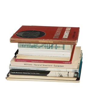
Sold2022Design & Architecture / Frei Otto books, 16Structural Design & Architecture / Frei Otto (1925-2015) books and monographs, collection of 16 1) Marks, Robert W., The Dymaxion World of Buckminster Fuller, Southern Illinois University Press, 1960See Sold Price
Sold2021Walt Disney World Epcot Center 1982 Map Poster. OffsetWalt Disney World Epcot Center 1982 Map Poster. Offset lithograph poster from the opening year of Epcot Center, showing a bird’s-eye view of the grounds and attraction areas. Morocco and EquatorSee Sold Price
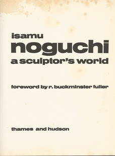
Sold2021A Sculptor's World. Foreword by R. Buckminster Fuller,A Sculptor's World. Foreword by R. Buckminster Fuller by NOGUCHI, Isamu.published by: Thames and Hudson, 1967. First Edition condition: Good, some foxing. HardcoverSee Sold Price
Sold2023OVERSIZED REPRODUCTION OF A 16TH C. MAPMonumental and highly decorative offset lithograph reproduction map of the world by Giovanni Marfei after Abraham Ortelius, originally published c. 1589 or 1593. Dimensions: (Frame) H 45" x W 84" CondSee Sold Price
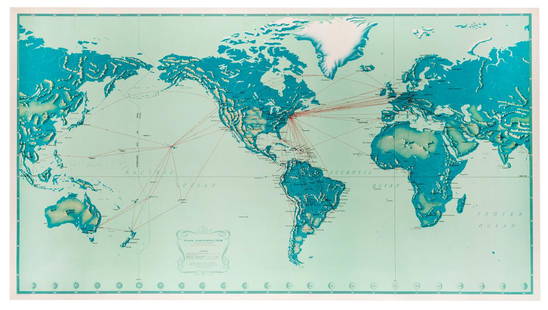
Sold2019Pan American Airways System. World Map 1956.Pan American Airways System. World Map 1956. Art by John Brown, cartography by John Philip. Offset poster showing the airline’s routes across the world. 34 x 60”. Inpainting to lower image, minorSee Sold Price
Sold2022Vintage Air France Airline Travel Routes World MapVintage Air France Airline Travel Routes World Map, by Lucien Boucher (French, 1889-1971) color offset, C.1948. Framed. Size: 19.5'' x 33.75'', 50 x 86 cm (sight); 24.5'' x 39'', 62 x 99 cm (frame).See Sold Price
Sold2018Pan American Airways System. World Map 1968Pan American Airways System. World Map 1968. Art by John Brown, cartography by John Philip. Offset poster showing the airline's routes across the world. Linen backed. 18 x 32". A.See Sold Price
Sold2020Latin Double Hemisphere Map in Bronze FrameDouble hemisphere map of the world by Henricus Hondius II (Dutch, 1597-1651), offset print, in a bronze frame. [Sight: 20 1/2 x 29 1/2 inches; Frame: 22 x 31 inches]. In good condition.See Sold Price
Sold2016T-O World Map.- Lucanus (Marcus Annaeus) Pharsalia,Lucanus (Marcus Annaeus) Pharsalia, manuscript on paper, [Northern Italy (possibly Padua), first half of the fifteenth century]. 294 x 217mm., I + 149 + I leaves (including defective leaves and 3 blanSee Sold Price
Sold2024Petrus Plancius, Engraved World MapOrbis Terrarum Typus de Integro Multis in Locis Emendatus. Petrus Plancius (1552-1622). Copper-plate engraving with original hand color in full. Amsterdam, 1594. Some stains, creases, folds. Sight sizSee Sold Price
2022Blaeu, Johannes (Netherlands, 1596-1673) "The New World Map" Double Hemisphere World Map C. 1664Nova et Accuratissima Totius Terrarum Orbis Tabula Translated "The New World Map", Hand Colored w/ Elaborately Decorated Spandrels.   Sight View 16" x 21-1/2", Overall View 21" x 25-1/2"See Sold Price
Sold2020Buckminster Fuller aluminum collapsible sculptureR. Buckminster Fuller (American 1895-1983)- "Jitterbug Atom"- aluminum collapsible sculpture, 1976, signed, edition of 150, very good condition. 8 1/2"hSee Sold Price
Sold2018Ortelius' 1570 world mapHeading: Author: Ortelius, Abraham Title: Typus Orbis Terrarum Place Published: Antwerp Publisher: Date Published: 1570-[1584?] Description: Copper-engraved map, hand-colorSee Sold Price
2018Important World Map from the Nuremberg Chronicle, 1493Title/Content of Map: World Map from the Nuremberg Chronicle. One of the most important world Maps ever produced Date Printed: 1493 Cartographer: Hartmann Schedel Material/Medium: Paper Size: 18" x 25See Sold Price
Sold2023A Witco Tiki Art World MapWorld Map mixed media sculpture mid century modern Witco 37.25 x 62.25 inches Overall very good condition.See Sold Price
Sold2017World mapWorld map 'Nova Totius Terraum Orbis Geographica Ac Hydrographica Tabula', copper engraving map of Heinrich Hondius, dated 1630,two hemispheres the world map, surrounded by rich allegorical representaSee Sold Price
Sold2020Mercator World Map*** START PRICE IS THE RESERVE *** [World] MERCATOR, Rumold (1545-1599). Orbis Terrae Compendiosa Descriptio Quam ex Magna Universali Mercatoris... Engraved Map with original hand color. Geneva, 1587.See Sold Price
Sold2022Massive World Map Custom-Made Coffee Table 1995One of a kind, all iron and custom glass work, signed in 1995. Aprox. Weight: 200 lbs -Measurements: 65 in L x 40 in x 23 in HSee Sold Price
Sold2016Beautifully Colored Jan Van Loon World MapOrbis Terrarum Nova... Jan Van Loon (c. 1611-1686). Engraved map with original hand color in full. London: Moses Pitt, 1680. 17 3/4 x 21 inches visible, 28 1/4 x 31 3/4 inches framed. A fine example oSee Sold Price
Sold2016Celebrated 16th Century World Map by Abraham OrteliusTypvs Orbis Terrarvum, Antwerp, dated 1587, with hand-coloring; Spanish text on the back credits the cartographer's sources in this updated edition showing the Solomon Islands and a corrected South AmSee Sold Price
Sold2017FRAMED WORLD MAP BY HERMAN MOLL, 1719'A New & Correct Map of the Whole World, by Herman Moll, Geographer, 1719.' Hand tinted and framed. Frame size: 73 x 124 cm (28 3/4 x 48 3/4 in.)See Sold Price
Sold2023Mercator, Rumold (1545-1599) World MapAn engraved double-page double hemispheric world map, "Orbis Terrae Compendiosa Descriptio". Dimensions:Sight is 11 1/4" x 20 3/4", the frame 21" x 29 1/2". Provenance:From a Philadelphia Collection.See Sold Price
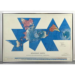
JG AutographsBuckminster Fuller - Architect, Inventor, Futurist - Autographed Spaceship Earth Sky-Ocean Map ModelUS$80(8 bids)
1 day LeftJasper521817 3 VOYAGES of CAPTAIN COOK 6 vols ILLUSTRATED w/ WORLD MAP antique in FRENCHUS$1,000
3 days LeftPotter & Potter AuctionsAir France / Reseau Aerien Postal. 1948. Paris: Perceval. L...US$150
3 days LeftPotter & Potter AuctionsPan American Airways World System Map. 1956. Art by John Br...US$200
Jun 01Northgate Gallery, Inc.Vintage Baker Furniture George II Style Wing Back Arm Chairs, PairUS$200
4 days LeftAlbion AuctionsCooke, George 1801 Antique Map. World Hemispheres by ArrowsmithUS$20(3 bids)
22 hrs LeftAkiba Galleries(2 Pc) Allain Manesson Mallet Description De L'Univers 2 Vol. German TranslationUS$200(1 bid)


![Latin Double Hemisphere Map in Bronze Frame: Double hemisphere map of the world by Henricus Hondius II (Dutch, 1597-1651), offset print, in a bronze frame. [Sight: 20 1/2 x 29 1/2 inches; Frame: 22 x 31 inches]. In good condition.](https://p1.liveauctioneers.com/1221/177486/89638020_1_x.jpg?height=310&quality=70&version=1599275200)
![T-O World Map.- Lucanus (Marcus Annaeus) Pharsalia,: Lucanus (Marcus Annaeus) Pharsalia, manuscript on paper, [Northern Italy (possibly Padua), first half of the fifteenth century]. 294 x 217mm., I + 149 + I leaves (including defective leaves and 3 blan](https://p1.liveauctioneers.com/5458/94966/48431616_1_x.jpg?height=310&quality=70&version=1476369049)


![Ortelius' 1570 world map: Heading: Author: Ortelius, Abraham Title: Typus Orbis Terrarum Place Published: Antwerp Publisher: Date Published: 1570-[1584?] Description: Copper-engraved map, hand-color](https://p1.liveauctioneers.com/642/127929/65081054_1_x.jpg?height=310&quality=70&version=1537227236)


![Mercator World Map: *** START PRICE IS THE RESERVE *** [World] MERCATOR, Rumold (1545-1599). Orbis Terrae Compendiosa Descriptio Quam ex Magna Universali Mercatoris... Engraved Map with original hand color. Geneva, 1587.](https://p1.liveauctioneers.com/1968/163248/82424686_1_x.jpg?height=310&quality=70&version=1583340284)


