Sold2020Latin Double Hemisphere Map in Bronze FrameDouble hemisphere map of the world by Henricus Hondius II (Dutch, 1597-1651), offset print, in a bronze frame. [Sight: 20 1/2 x 29 1/2 inches; Frame: 22 x 31 inches]. In good condition.See Sold Price
Sold2021Decorative Framed Double Hemisphere MapDESCRIPTION: A decorative framed double hemisphere map with figural and gilt details throughout. Mounted in a gilt accented wood frame. Marked: "The Bombay Company" at reverse. CIRCA: 20th Cent. ORIGISee Sold Price
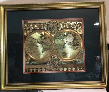
Sold2020Double Hemisphere World MapOverall with frame 37 1/4" high x 37" wide. IMPORTANT: Before bidding, please read the terms and conditions below. When you registered for the auction you agreed to these terms and will be required toSee Sold Price
Sold2023Vintage GOLD FOIL WORLD MAP DOUBLE HEMISPHERE 25x31 FRAMED Wall HangingVintage Huge GOLD FOIL WORLD MAP DOUBLE HEMISPHERE 25x31 FRAMED Wall Hanging in a Gorgeous Gold Leaf Frame in VG Condition. Local Pickup Only in Berlin NJ 08009 or UPS Store Shipping Paid for by the WSee Sold Price
Sold2020Framed 1822 World Map, FrenchDated 1822 world map in frame. This map is hand colored and tilted Mappemomde (French for a map showing two hemispheres). This map is double matted in contemporary frame.Condition: very good conditionSee Sold Price
Sold2019Old' and 'New' hemispheresTitle/Content of Map: Old' and 'New' hemispheres. Cartographer: Pierre Tardieu Date Printed:1830 Material/Medium: Paper Size: Size Image 40 x 21 cm. Size Frame 55 x 36 An unusual double hemisphere worSee Sold Price
Sold2022Adam Friedrich (1679-1742) Double Hemisphere MapProperty of a Private Collector, Hilton Head Island, SC Description: Adam Friedrich (1679-1742), Planisphaerium Terrestre Cum Utraque Coelesti Hemisphario, Amsterdam: Nicolaum Vissche, c. 1700 orSee Sold Price
Sold20191628 Vaughan double Hemisphere Map of the World -- AReserve Reduced! Title/Content of Map: 1628 Vaughan double Hemisphere Map of the World -- A New and accurate Mappe of the World, drawne according to the best and latest discoveries that have beene madSee Sold Price
Sold2024Ptolemy & Magini, pub. 1620 - Double Hemisphere Map of the WorldThis early map engraving is from Claudius Ptolemaeus (Ptolemy) and Giovanni Antonio Magini's Geografia cio? Descrittione Universale della Terra Partita in due volumni, Nel Primo de' quali si contengonSee Sold Price
Sold2024[WORLD]. ROBISON, Edward C. Manuscript double-hemisphere map of the world. 1831.[WORLD]. ROBISON, Edward C. Manuscript double-hemisphere map of the world. 1831. 1830 Manuscript double-hemisphere map of the world, in ink and colors, hand-colored in outline, within pink and green bSee Sold Price
Sold2019John Wanamaker Victorian Double Bronze FrameJohn Wanamaker Victorian Double Bronze Frame. 9" x 6"See Sold Price
Sold20191784 Two Double Hemisphere Maps ProjectionsTwo double hemisphere projections, one being a Stereographic map and the other with an Orthographic Projection, both published by Harrison and Co, London, 1784. Each Fine, measures 10 x 8”. Reserve:See Sold Price
Sold2022Marvelous pictorial map of the WorldHeading: (Maps) Author: Ensign & Thayer Title: World at One View Place Published: New York Publisher: Date Published: 1847 Description: Lithographed double-hemisphere map of theSee Sold Price
Sold2023[MAP]. HOMANN, Johann Baptist (1663-1724). Planiglobii Terrestris cum utroq Hemisphaerio[MAP]. HOMANN, Johann Baptist (1663-1724). Planiglobii Terrestris cum utroq Hemisphaerio Caelesti… Nuremberg, [ca 1720]. Engraved double-hemisphere map of the world with hand-coloring in wash anSee Sold Price
Sold20244 Antique Maps of Various LocationsFrench Map of Canada By Guillaume Del'Isle, Map Of Asia By Guiljelmo Blaeuw, Double Hemisphere map By Nicolao Visscher, Map Of The Holy Land Jerusalem, all maps are roughly 18" x 14"See Sold Price
Sold2017Launay World Map - Typus Orbis Terrarum, 1720Map: Launay World Map - Typus Orbis Terrarum Cartographer: C. Launay Date: ca. 1720 Size: 5 x 8 inches A quite rare, unique and charming double hemisphere map showing very rough approximations for theSee Sold Price
Sold2023Planiglobii Terrestris Mappa Universalis Utrumqs Hemisphaerium Orient et OccidentaleNeuremberg: Homann Heirs, 1746. Double hemisphere map of the world, with four globes tangential to the hemispheres, showing earth from various angles in addition to the expected polar views. Two diagrSee Sold Price
Sold2021De L'Isle Philippe Buache engraved map of Antique ItalyDe L'Isle Philippe Buache Double hemisphere map of Antique Italy 1800 Important map of Guillaume de L'Isle corrected by Philippe Buache and edited by Dezauche in 1800 ,This one is not revised by DezauSee Sold Price
Sold2021After Henricus Hondius II (Dutch, 1597-1651)After Henricus Hondius II (Dutch, 1597-1651) , "Nova Totius Terrarum Orbis Geographica AC Hydrographica Tabula", later printing, hand-colored double-hemisphere map, exuberantly decorated with represenSee Sold Price
Sold20181782 A New Map of the World1782 "A New Map of the World", double hemisphere map published by Harrison and Co., London, 1782. Folding map, measures 17 x 10". Fine, mild discoloration. Reserve: $80.00 Shipping: Domestic: Flat-ratSee Sold Price
Sold20191782 A New Map of the World1782 “A New Map of the World”, double hemisphere map published by Harrison and Co., London, 1782. Folding map, measures 17 x 10”. Fine, mild discoloration. Reserve: $80.00 Shipping: Domestic: FlSee Sold Price
2022Blaeu, Johannes (Netherlands, 1596-1673) "The New World Map" Double Hemisphere World Map C. 1664Nova et Accuratissima Totius Terrarum Orbis Tabula Translated "The New World Map", Hand Colored w/ Elaborately Decorated Spandrels.   Sight View 16" x 21-1/2", Overall View 21" x 25-1/2"See Sold Price
Sold20201746 Homann Double Hemisphere World Map -- PlaniglobiiTitle/Content of Map: 1746 Homann Double Hemisphere World Map -- Planiglobii Terrestris Mappa Universalis utrumque Hemisphaerium Orient et Occidentale Repraesentans ex IV. Mappis Generalibus ... / MapSee Sold Price
Sold2021Double hemisphere world map with additionalTitle: Double hemisphere world map with additional projections. 1752 by Homann Heirs Date/Period: 1762 Materials: Copperplate engraved Size: 24 x 20 1/2 1762, by J. B. Homann & Homann Heirs, from "AtlSee Sold Price
Featured1 day LeftJasper521719 Chatelain World Map -- Mappe-Monde pour Connoitre les Progres & les Conquestes les PlusUS$280
1 day LeftJasper521693 Conelly Chart of the Earth and Geographic Principles -- Primi Elementi, o Introdutione al CorsoUS$240
2 days LeftDoyle New YorkThe top sheet of the famous Ratzer Map - with additions relating to an 1810 real estate disputeUS$7,500
1 day LeftJasper52c1720 World showing Dutch East India Co possessions. CA as a island. By J.MalherbeUS$650
5 days LeftTrillium Antique Prints & Rare BooksBloch, Folio - Japanese Grunt & Double String Fish; Anthias Japonicus & A. Bilineatus. 325US$50
1 day LeftJasper521710 HISTORY by LIVY 10 volumes Historiarum quod extat antique VELLUM BINDINGUS$650
5 days LeftJay Anderson AuctionPair of American Gilt & Dark Bronze Double Argand Lamps,signed Lewis Veron & Co Philadelphia. CircaUS$850(2 bids)
6 days LeftKellie's Estate SalesAcadia National Park Framed Map 1966 Sunrise over Acadia map by August D. Phillips of NortheastUS$5


![Latin Double Hemisphere Map in Bronze Frame: Double hemisphere map of the world by Henricus Hondius II (Dutch, 1597-1651), offset print, in a bronze frame. [Sight: 20 1/2 x 29 1/2 inches; Frame: 22 x 31 inches]. In good condition.](https://p1.liveauctioneers.com/1221/177486/89638020_1_x.jpg?height=310&quality=70&version=1599275200)


![[WORLD]. ROBISON, Edward C. Manuscript double-hemisphere map of the world. 1831.: [WORLD]. ROBISON, Edward C. Manuscript double-hemisphere map of the world. 1831. 1830 Manuscript double-hemisphere map of the world, in ink and colors, hand-colored in outline, within pink and green b](https://p1.liveauctioneers.com/197/321050/172516760_1_x.jpg?height=310&quality=70&version=1709074257)


![[MAP]. HOMANN, Johann Baptist (1663-1724). Planiglobii Terrestris cum utroq Hemisphaerio: [MAP]. HOMANN, Johann Baptist (1663-1724). Planiglobii Terrestris cum utroq Hemisphaerio Caelesti… Nuremberg, [ca 1720]. Engraved double-hemisphere map of the world with hand-coloring in wash an](https://p1.liveauctioneers.com/197/284572/150193667_1_x.jpg?height=310&quality=70&version=1680880467)


