Sold2023Dated Events War Map 28th EditionThe Dated Events War Map series went through over 30 different iterations by numerous printing houses in Canada and the United States. This is one of the last examples, Edition 28, issued in the monthSee Sold Price
Sold20191945 Turner Dated Events War Map -- Dated Events WarTitle/Content of Map: 1945 Turner Dated Events War Map -- Dated Events War Map Cartographer: S TurnerDate: 1945, New York Size: 17 x 38.8 in. This is a large world map, detailing the key events towardSee Sold Price
Sold20181942 Turner Dated Events War Map -- Dated Events WarTitle/Content of Map: 1942 Turner Dated Events War Map -- Dated Events War Map Date Printed: 1942, New York Cartographer: S Turner Size: 17 x 38.8 in. This is a large world map, detailing the key evenSee Sold Price
Sold2023Vintage Colored DATED EVENTS WAR MAP WWIIProvenance from a collector in RI. We have included quality images to show the condition. The shipment will be made directly by Artelisted. Please, consider that packing fine art will probably take moSee Sold Price
Sold2020WWII 1942 DATED EVENTS WORLD WAR MAP by PETERSENWWII 1942 DATED EVENTS WORLD WAR MAP by PETERSEN ADVERTISING, Zitelli PITTSBURGH World War II Era DATED EVENTS WAR MAP--World map with war details highlighted. Copyright, Canada and USA 1942, C. C. PeSee Sold Price
Sold2019Gettysburg Battlefield - Civil WarGettysburg Battlefield The Definitive Illustrated History, Civil War. Author: David Eicher Illustrations Numerous Illus. & Maps Dated:See Sold Price
Sold2023APRIL 24, 1944 MUNICH BOMBING MAP AND BOMB RELEASE BUTTONBritish War Office 1:500,000 scale air map of Munich and the surrounding area, 28 x 24 in., originally compiled and drafted at the War Office in 1940, this second edition dated 1942. This perticular mSee Sold Price
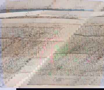
Sold2023WWII U.S. MILITARY WAR MAPS OF FRANCE - (3)171283 WWII U.S. MILITARY WAR MAPS OF FRANCE - (3) WWII U.S. military war maps of France to include, one sheet 6F/6 Vire France(50000) war map second edition, one sheet 6E/6 Isigny France(50000) war mSee Sold Price
Sold2023IMPORTANT DATED 1780 REVOLUTIONARY WAR MAP HORN CANNONEER'S SIZE W/ FORTS, ALBANY, NY, SARATOGA,IMPORTANT DATED 1780 REVOLUTIONARY WAR MAP HORN CANNONEER'S SIZE W/ FORTS, ALBANY, NY, SARATOGA, ETC. 27" LONGSee Sold Price
Sold2022Antique Etching Of A War Map Dated 1658 See Pic For TranslationAntique Etching Of A War Map Dated 1658 See Pic For Translation. Measure 12.5" X 16 1/4". Please carefully read our terms of sale, shipping information, and request any condition reports or photos priSee Sold Price
Sold2017Revolutionary War Map of the Battle of SaratogaAmerican Revolution 1780 Revolutionary War Map Engraved by William Faden 1780-Dated Revolutionary War, Hand-Colored Map entitled, “Plan of the Encampment and Position of the Army Under His Excelly.See Sold Price
Sold20191865 1st Ed ABRAHAM LINCOLN Memorial Sheet MusicAbraham Lincoln Related 1865 1st Edition: "The Nation Mourns. FUNERAL MARCH, To The Memory of ABRAHAM LINCOLN" 1865-Dated Civil War Period, 1st Edition Printed Sheet Music, by Mrs. E.A. Parkhurst, PubSee Sold Price
Sold2023Books Great Events of the Great War Registered Edition 1923 7 BooksHandsome set of 7 books on WWI. These books were made for those that fought in the war and sent as Registered Editions. This edition was registered to Sergeant Joseph C. Cissel of KentuckySee Sold Price
Sold2022Noel Nouet: Ryogoku Bridge Tokyo 1936 WoodblockJapanese Woodblock Print, 1936, dated in block, early post war edition with Ito/Seki carver/printer seal in the left margin, published by Doi on watermarked paper SIZE IN INCHES: 10.25 x 15.5 inches NSee Sold Price
Sold2021U. S. TERRITORY STILL UNDER INSURRECTIONARY CONTROLCivil War Dated Wood Engraved Map MAP SHOWING THE EXTENT OF UNITED STATES TERRITORY STILL UNDER INSURRECTIONARY CONTROL, Harper's Weekly, June 28, 1862 (Civil War, Confederate States, Rebels, SuccessiSee Sold Price
Sold2023FIRST EDITION OF RARE REVOLUTIONARY WAR MAPCarte Nouvelle des Possessions Angloises en Amérique dressée pour l'intellegence de la guerre, Paris 1777, Maurille Antoine Moithey, engineer. Translation: New map of the English possessionsSee Sold Price
Sold2017Johnson: Antique 1st Edition Civil War Military Map1st edition Johnson’s Civil War Military Map, Johnson & Browning. Scarce 1861 map by A. J. Johnson showing the military deportment of the United States in 1860, just before war broke out in the statSee Sold Price
Sold2023Antique Map Print - America - Revolutionary War Event the Battle of White PlainsTitle/Artist: Antique Map Print - America - Revolutionary War Event the Battle of White Plains Date: 1807 Material: Paper Dimensions: 45 cm x 28 cm Description: Antique uncolored map of the area alongSee Sold Price
Sold20221761 Map of Carthage as Part of Roman Empire EtcHistoric Maps 1761 Map: "SUITE DE L'HISTOIRE DE CARTHAGE,..." 1761-Dated French & Indian War Period, Hand-Colored Map fully titled, "SUITE DE L'HISTOIRE DE CARTHAGE, DEPUIS L'AN 3786 JUSQU'A L'AN 3860See Sold Price
Sold20221863, A HISTORY OF THE CIVIL WAR IN AMERICACivil War Publications 1863 Civil War Printed "A CHRONOLOGICAL HISTORY OF THE CIVIL WAR IN AMERICA" by Richard Fisher MD 1863-Dated First Edition Civil War Period Book titled, "A CHRONOLOGICAL HISTORYSee Sold Price
Sold20231865 1ed Ulysses S Grant & General Sherman Civil War Campaign Battles Maps1865 1ed Ulysses S Grant & General Sherman Civil War Campaign Battles Maps A rare first edition printing of Joel Tyler Headleys, Grant and Sherman; Their Campaigns and Generals. This work was publisheSee Sold Price
Sold2023Wilson, History of Napoleonic Wars 1st US Edition 1817, Map"A Sketch of the Military and Political Power of Russia in the Year 1817", (anonym) by Robert Thomas Wilson, published by Kirk and Mercein, Wall-Street, New York, in 1817. The fold-out map of Russia iSee Sold Price
Sold2024Frederic Paxson, The Civil War, 1st Holt Edition, 1911, Maps"The Civil War" by Frederic L. Paxson, published by Henry Holt and Company, New York, 1911. First edition. Hard boards, original pale-brown cloth, black lettering and decorations on front board and spSee Sold Price
4 days LeftBlackstone Valley Auctions & Estates LLCRevolutionary Era War Map of the Attack on Ft. Moultrie.US$275(3 bids)
May 30Forum AuctionsChurchill (Sir Winston Spencer) The Second World War, vol. 1 only, first edition, signed by the£800
May 31Freeman's | Hindman[CIVIL WAR]. Archive of items related to Elisha Hunt RHODES (1842-1917), 2nd Rhode Island VolunteerUS$750
20 hrs LeftJasper52CENTRAL EUROPE. 1914-1920 border changes due to First World War 1 1920 old mapUS$20
1 day LeftPotter & Potter AuctionsTUNIS, Edward (1897 – 1973). From Chesapeake Bay / Land of ...US$250
May 30Forum AuctionsStevenson (Robert Louis) Treasure Island, first edition, first issue, 1883.£1,000
6 days LeftBonhamsThe War in India: Despatches of the Rt. Hon. Lt. General Viscount Hardinge, Governor-General of ...£1,200
2 days LeftZikorn Arts & History ObjectsKay Thompson: Eloise in Moscow, 1959 First PrintingUS$100(1 bid)


![[CIVIL WAR] ALBUMEN + TRANSCRIPTION OF LETTER (1 of 3)](https://p1.liveauctioneers.com/8124/329803/177770572_1_x.jpg?height=282&quality=70&version=1715634941)


![[CIVIL WAR]. Archive of items related to Elisha Hunt RHODES (1842-1917), 2nd Rhode Island Volunteer (1 of 6)](https://p1.liveauctioneers.com/197/329785/177758366_1_x.jpg?height=282&quality=70&version=1715625218)


