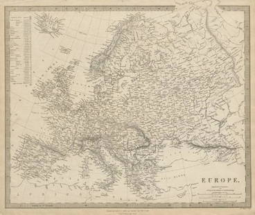
Sold2023EUROPE. General map. Inset table of population & density by country. SDUK 1844TITLE/CONTENT OF MAP: 'EUROPE; inset table of population by country' DATE PRINTED: This map was originally published by Baldwin & Cradock in 1836; this date is printed on the map. This edition of theSee Sold Price
Sold2016United States Map, Density of Population, 1895Original engraving from Atlas of the World by Rand McNally, 1895. Map includes counties, geographical landmarks, streets and population data. Dimensions: 21 1/4" x 14" No Reserve Buyer pays shipping -See Sold Price
Sold20211900 US Census Map of Immigrant Populations -- DensityTitle: 1900 US Census Map of Immigrant Populations -- Density of Foreign Born Population of the United States at the Twelfth Census 1900 Cartographer: US Department of the Interior Year / Place: 1900See Sold Price
Sold20201953 Map of Los Angeles Population Density -- 1953Title: 1953 Map of Los Angeles Population Density -- 1953 Density of Population - Persons per Acre in Study Area by Postal Zones Cartographer: Los Angeles Metro Transit Authority Year / Place: 1953 MaSee Sold Price
Sold20211900 US Population Density MapAuthor: Mc Nally Title: 1900 US Population Density Map Medium: Ink on Paper Dimensions: 21"X14.5" US population density map dated 1900. Printed and published by the Rand McNally Co. Part of the IndexeSee Sold Price
Sold2017Map of the United States showing Density of PopulationRand, McNally & Co. 1898 New Standard Atlas of the World. Also contains census information on population 1870, 1880, and 1890 Size: 21 x 15 inches No Reserve: This lot starts at $1 and has no reserveSee Sold Price
Sold20201900 US Census Map of Immigrant Populations -- DensityTitle: 1900 US Census Map of Immigrant Populations -- Density of Foreign Born Population of the United States at the Twelfth Census 1900 Cartographer: US Department of the Interior Year/Place: 1900 SiSee Sold Price
Sold20211898 Rand McNally US Population Density Map -- RandTitle: 1898 Rand McNally US Population Density Map -- Rand McNally & Co.'s Map of the United states Showing in Six Degrees the Density of Population, 1890 Cartographer: Rand McNally Year / Place: 1898See Sold Price
Sold2024WEST ASIA.Arabia Persia Mesopotamia Russia.Rainfall population density 1920 mapTITLE/CONTENT OF MAP: 'Asia (General); Inset map of Siberia; Mongolia' DATE PRINTED: 1920 IMAGE SIZE: Approx 32.5 x 22.0cm, 12.75 x 8.75 inches (Large) TYPE: Vintage colour map; Scale 1:29,500,000 CONSee Sold Price
Sold20211900 US Census Map of African American Populations --Title: 1900 US Census Map of African American Populations -- Density of Negro Population of the United States at the Twelfth Census 1900 Cartographer: US Department of the Interior Year / Place: 1900See Sold Price
Sold20201900 US Census Map of African American Populations --Title: 1900 US Census Map of African American Populations -- Density of Negro Population of the United States at the Twelfth Census 1900 Cartographer: US Department of the Interior Year/Place: 1900 SiSee Sold Price
Sold2021Bartholomew, John 1904 Lot of 3 Maps of ScotlandIncl Density of Population Central Scotland, Parliamentary Representation of Scotland, and Glasgow City Plan. Lithograph Maps Published 1904, London for "The Survey Gazetteer of the British Isles" UncSee Sold Price
Sold2021Bartholomew, John 1904 Lot of 6 British MapsIncl Naval & Military Divisions, Parliamentary Boroughs, County Divisions, Ecclesiastical Divisions, Density of Population, and Valuation of Land. Lithograph Maps Published 1904, London for "The SurveSee Sold Price
Sold2019Bartholomew, John 1922 Lot of 4 Maps of EuropeIncl Europe Political, Eastern Europe Political, Western Europe Political, and Europe Physical Features & Population. Large Lithograph Maps Published 1922 by The Times, London for "The Times Survey AtSee Sold Price
Sold2020Bartholomew, John 1922 Lot of 4 Large Maps. EuropeIncl Europe Political, Orography/Vegetation/Races/Population, Western Europe Politcal, Eastern Political. Large Lithograph Maps Published 1922 by The Times, London for "The Times Survey Atlas of the WSee Sold Price
Sold2020Bartholomew, John 1922 Lot of 4 Maps. EuropeIncl Europe Political, Orography/Vegetation/Races/Population, Western Europe Political, and Eastern Europe Political. Large Lithograph Maps Published 1922 by The Times, London for "The Times Survey AtSee Sold Price
Sold2018SDUK: Antique Map of Europe, 1845TITLE/CONTENT OF MAP: 'EUROPE; inset table of population by country' The map shows Lombardia-Venetia as part of the Austrian Empire, the independent Ionian Islands, and Turkish Crete DATE PRINTED: 184See Sold Price
Sold2019EUROPE. General map. Inset table of population &TITLE/CONTENT OF MAP: 'EUROPE; inset table of population by country' The top image on the right hand side shows the entire map. To view a close up of the map showing the level of printed detail, pleasSee Sold Price
Sold20221900 US Census Map of Irish in the US -- Density ofTitle: 1900 US Census Map of Irish in the US -- Density of Natives of Ireland: 1900 [together with] Proportion of Natives of Ireland to Total Population: 1900 Cartographer: US Department of the InteriSee Sold Price
Sold2023TWAIN MARK: (1835-1910)TWAIN MARK: (1835-1910) Samuel Langhorne Clemens. American writer and humourist. A fine, long A.L.S., Samuel, eight pages, 8vo, 'Study' [Hartford, Connecticut], n.d. ('Tuesday. P.M.', October 1880), tSee Sold Price
Sold2023DISNEY WALT: (1901-1966)DISNEY WALT: (1901-1966) American animator, Academy Award winner. An excellent, original pencil drawing signed by Walt Disney, one page, 4to, n.p. (Burbank. California), n.d. (1940s). Disney has execuSee Sold Price
Sold2021SAINT VINCENT DE PAUL: (1581-1660)SAINT VINCENT DE PAUL: (1581-1660) French Catholic Priest. Venerated both in the Catholic Church and the Anglican Communion. Canonized in 1737 by Pope Clement XII. Vincent de Paul is known for his humSee Sold Price
Sold2021SAINT VINCENT DE PAUL: (1581-1660)SAINT VINCENT DE PAUL: (1581-1660) French Catholic Priest. Venerated both in the Catholic Church and the Anglican Communion. Canonized in 1737 by Pope Clement XII. Vincent de Paul is known for his humSee Sold Price
Sold2022TESLA NIKOLA: (1856-1943)TESLA NIKOLA: (1856-1943) Serbian-American Inventor and Engineer. Best-known for his contributions to the design of alternating current electricity supply systems. Tesla worked for a short time at theSee Sold Price
5 days LeftConestoga Auction Company Division of Hess Auction GroupEarly 19th C. Europe Camping Scene Oil on Canvas.US$50(1 bid)
BonhamsSIX FLORAL TILES, England and Europe, c. 1900, two-tile panel, Hague, Rozenburg, maker's mark, t...US$150
May 16Potter & Potter AuctionsROGERS, Harry (1929 – 2012). Europe / Qantas. Australia: Po...US$150(1 bid)
May 08The Benefit Shop Foundation Inc.Corona Decor Co Fruit Basket Flower Tapestry, EuropeUS$5(2 bids)
May 14Hermann Historica GmbHA porcelain figure showing "Europe on the Bull", Adolph Amberg, 1909 (design), KPM, 20th century€480
1818 AuctioneersA Danbury Mint, Champions of Europe 1999, Manchester United 13 players and Sir Alex Ferguson ceramic£340(10 bids)
3 days LeftDoyle New YorkAn attractive set of Dresser's monumental History of the Birds of EuropeUS$4,000
Featured2 days LeftJasper521792 Elwe Map of Southern Russia in Europe -- Partie Meridionale de Moscovie Dresse par G. De L'IsleUS$190
May 17Ni-Cola Classics - Automobilia Auction & Classic Car SalesAlfa Romeo Original b/w press photo GP of Europe Spa 1925€150


![1900 US Census Map of Irish in the US -- Density of: Title: 1900 US Census Map of Irish in the US -- Density of Natives of Ireland: 1900 [together with] Proportion of Natives of Ireland to Total Population: 1900 Cartographer: US Department of the Interi](https://p1.liveauctioneers.com/5584/234329/121339941_1_x.jpg?height=310&quality=70&version=1643151143)
![TWAIN MARK: (1835-1910): TWAIN MARK: (1835-1910) Samuel Langhorne Clemens. American writer and humourist. A fine, long A.L.S., Samuel, eight pages, 8vo, 'Study' [Hartford, Connecticut], n.d. ('Tuesday. P.M.', October 1880), t](https://p1.liveauctioneers.com/1458/299335/159358764_1_x.jpg?height=310&quality=70&version=1692296567)


