Sold2016Framed and matted Indian Territory map of OKFramed and matted Indian Territory map of Oklahoma. 20" x 17".See Sold Price
Sold2020ARBUCKLES INDIAN TERRITORY MAP, C.1889Framed colorful card map of the Indian Territory, illustrated with bison, Indians and accoutrements, a chromolithograph, patent date 1889, given as a premium with Arbuckle Brothers coffee and publisheSee Sold Price
Sold2023Two Antique Maps of Indian Territories British America Far WestTwo Antique Maps of Indian Territories British America Far West MEDIUM: Published Printing DIMENSIONS: Framed 18 x 27 inches DESCRIPTION: These early antique maps of British America show Districts, InSee Sold Price
Sold2021Framed 1822 French map of IndianaFramed 1822 French map of Indiana, shows Indian territories and 35 of the 92 counties, but it's in French! 25.5"H x 32"W overall in contemporary frameSee Sold Price
Sold2021The United States of America, Including Newly AcquiredThe United States of America, Including Newly Acquired Territory. Boston: The National Publishing Company, 1902. Chromolithographed map, matted and framed 38 1/2 x 57 1/4 inches. Property from a CorpoSee Sold Price
Sold20211873 Texas and Indian Territory MapAuthor: Bartholomew Title: 1873 Texas and Indian Territory Map Medium: Ink on Paper Dimensions: 17.5"X13" Map of Texas and the Indian Territory dated 1873. Part of Zell's Descriptive Hand Atlas of theSee Sold Price
Sold20221892 Johnson Map of Oklahoma and Indian Territory -- Map of OklahomaTitle: 1892 Johnson Map of Oklahoma and Indian Territory -- Map of Oklahoma Cartographer: A J Johnson Year / Place: 1892, New York Map Dimension (in.): 5.9 X 8 in. This is fascinating map showing theSee Sold Price
Sold2022Gray’s New Map of Texas and Indian Territory, 1884Impressive and huge, hand colored map of the Lone Star State with complete view of Indian Territory. Map features seven insets: (1) The River System of Texas and the Indian Territory; (2) Part of TexaSee Sold Price
Sold20191900 Plat Map of a Section of Cherokee Nation Land --Reserve Reduced! Map Title/Content: 1900 Plat Map of a Section of Cherokee Nation Land -- Cherokee Nation Township 22 North, Range 21 East Cartographer: Indian Territory Map Co. Year / Place: 1900 c.See Sold Price
Sold20181900 Plat Map of a Section of Cherokee Nation Land --Title/Content of Map: 1900 Plat Map of a Section of Cherokee Nation Land -- Cherokee Nation Township 22 North, Range 21 East Date: 1900 c. Muskogee, Ind. Terr. Cartographer: Indian Territory Map Co. SSee Sold Price
Sold2018Asher & Adams: Antique Map of Indian Territory, 1874Title/Content of Map: 1874 Asher & Adams Indian Territory Map -- Asher & Adams Indian Territory and Texas North West Portion Date Printed: 1874, New York Cartographer: Asher & Adams Size: 16.3 x 23.2See Sold Price
Sold2020Framed Indian Ocean MapIndian Ocean map featuring whaling routes and marked J. S. Hobbs in a plexiglass-glass frame. Condition: excellent. call for additional condition report.Size: 83in x 48inSee Sold Price
Sold2016Framed and matted map of Upper and Lower Canada datedFramed and matted map of Upper and Lower Canada dated 1798, published in 1798 by J. Stockdale. Site-7.25"h.x9.5"w.See Sold Price
Sold2018Framed & Matted Vintage Map Of The BermudasAntique Map Of The Bermudas, this colored map is professionally framed and matter in a black with gold detailed frame with maroon matting, it is measured at 27.5 x 23 inchesSee Sold Price
Sold2021VINTAGE GILT FRAMED AND MATTED MAPVINTAGE GILT FRAMED AND MATTED MAP. Height: 27 by Width: 32See Sold Price
Sold2021Antique 18th C Hand Colored Engraving Map AntillesAntique 18th Century Hand Colored Engraving Map of Antilles. Depicting the West Indies. Professionally framed and matted. Map measures 19 inches high x 23 inches wide. Frame measures 25.25 inches highSee Sold Price
Sold2020Framed Map of Ireland etc.Framed and matted map of Ireland by Herman Mull 12" x 11" sight size / 17.5" x 16.5" overall; together with two other mapsSee Sold Price
Sold2017Lloyd: Map of Kansas and Other Territories, 1872Map: Kansas, and the Territories of Arizona, Colorado, New Mexico, Utah and Indian Territory (antique map) Cartographer: H.H. Lloyd Publisher: Stedman, Brown & Lyon Date: 1872 Size: 15.375 x 24.5 inchSee Sold Price
Sold2023Indian Vignette Bank Checks [171015]Lot of three Indian vignette bank checks: Bank of Ouray, 1898 with revenue stamp; 2) Bank of Indian Territory, Guthrie, OK., 1900; 3) Navajo County Bank, Winslow, Arizona, 1906.See Sold Price
Sold2021GERARD ERNEST SCHNEIDER ABSTRACT OIL/PAPER V$2,500MEASUREMENTS:25"HX31"W WITH THE FRAME/FRAMED AND MATTED/OK CONDITION MOISTURE SPOTS AND WRINKLING, FRAME HAS DAMAGE ON CORNERS/"in the styl of"Gérard Ernest Schneider. Gérard Ernest Schneider waSee Sold Price
Sold2024MAP OF LE CERCLE DE LA HAUTE SAXEFramed and matted map Le Cercle de le Cercle de la Haute Saxe dated 1696. 22.25" x 34.5" ss / 29" x 40.5" oaSee Sold Price
Sold2021Large Map of Oklahoma & Indian TerritoriesMap of Oklahoma & Indian Territories With map of New Mexico on verso Cartographer: George Franklin Cram Dated: Circa 1900 Type: Color LithographSee Sold Price
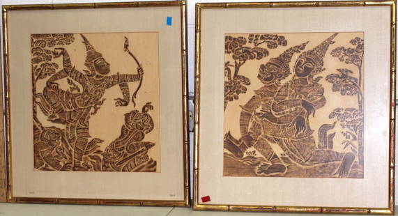
Sold20192 Framed Matted Prints of Indian Scenes2 Framed Matted Prints of scenes from IndiaSee Sold Price
Jun 07Freeman's | HindmanBELLIN, Jacques-Nicolas. Carte Reduite de L'Ocean Oriental ou Mer Des Indies. Paris, 1757. SecondUS$150
Jun 12Dan Morphy AuctionsPLATE CXIII. MAP OF INDIAN TERRITORY SHOWING DISTRIBUTION OF WOODLAND” FROM THE TWENTY-FIRSTUS$100
Jul 11Dan Morphy AuctionsRARE INDEPENDENT GASOLINE & MOTOR OIL FRAMED GRAPHIC HIGHWAY MAP OF ILLINOIS.US$125
Jun 12Dan Morphy AuctionsMAP OF THE CHOCTAW NATION, INDIAN TERRITORY - COAL AND ASPHALT SEGREGATION 1903US$150
Jun 12Dan Morphy AuctionsMAP OF THE CHOCTAW NATION, INDIAN TERRITORY - COAL AND ASPHALT SEGREGATION 1903US$100
Jun 07Freeman's | Hindman[MAP]. ORTELIUS, Abraham. Peregrinationis Divi Pauli Typus Corographicus. 1592.US$150(1 bid)
Jun 07Freeman's | Hindman[MAP]. ORTELIUS, Abraham. Presbiteri Iohannis, sive, Abissinorum Imperii Descriptio. 1592.US$200
1 day LeftArarity AuctionsThomson's 1817 Hand Colored Map Comparative Heights of the World's Great MountainsUS$50
Jun 12Dan Morphy AuctionsINDIAN TERRITORY - DEPARTMENT OF THE INTERIOR GENERAL LAND OFFICE, C.1883US$100
Jun 02Tremont AuctionsEarly 20th century Native American Indian ledger drawing. Depiction of a brave on horseback. LedgerUS$300
Jun 08Early American History Auctionsc 1730 Hand-Colored Colonial Era Map of the Americas, California shown as an Island, Matted + FramedUS$500(1 bid)
Jun 08Early American History Auctions1836 Hand-Colored Map, Country Twenty Five Miles Round The City Of New-York Published by D.S. StoneUS$260


![Indian Vignette Bank Checks [171015]: Lot of three Indian vignette bank checks: Bank of Ouray, 1898 with revenue stamp; 2) Bank of Indian Territory, Guthrie, OK., 1900; 3) Navajo County Bank, Winslow, Arizona, 1906.](https://p1.liveauctioneers.com/2699/311018/166408189_1_x.jpg?height=310&quality=70&version=1701193734)


![[MAP]. ORTELIUS, Abraham. Turcici Imperii Descriptio.1592. (1 of 2)](https://p1.liveauctioneers.com/197/329395/177650538_1_x.jpg?height=282&quality=70&version=1715364962)
![[MAP]. ORTELIUS, Abraham. Aevi Veteris, Typus Geographicus. 1601. (1 of 3)](https://p1.liveauctioneers.com/197/329395/177650532_1_x.jpg?height=282&quality=70&version=1715364962)
![[MAP]. ORTELIUS, Abraham. Romani Imperii Imago. 1592. (1 of 2)](https://p1.liveauctioneers.com/197/329395/177650537_1_x.jpg?height=282&quality=70&version=1715364962)
![[MAP]. ORTELIUS, Abraham. Peregrinationis Divi Pauli Typus Corographicus. 1592. (1 of 2)](https://p1.liveauctioneers.com/197/329395/177650535_1_x.jpg?height=282&quality=70&version=1715364962)
![[MAP]. ORTELIUS, Abraham. Africae Tabula Nova. 1592. (1 of 2)](https://p1.liveauctioneers.com/197/329395/177650533_1_x.jpg?height=282&quality=70&version=1715364962)
![[MAP]. ORTELIUS, Abraham. Presbiteri Iohannis, sive, Abissinorum Imperii Descriptio. 1592. (1 of 2)](https://p1.liveauctioneers.com/197/329395/177650536_1_x.jpg?height=282&quality=70&version=1715364962)


