Sold2019Rare 1st ed. map of world diseases, c1848World map showing the spread of diseases across the globe in mid-19th century. Three inset maps show diseases in North America, the spread of cholera throughout the world and South Africa. Charts andSee Sold Price
Sold2019Pan American Airways System. World Map 1956.Pan American Airways System. World Map 1956. Art by John Brown, cartography by John Philip. Offset poster showing the airline’s routes across the world. 34 x 60”. Inpainting to lower image, minorSee Sold Price
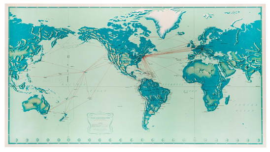
Sold2018Pan American Airways System. World Map 1968Pan American Airways System. World Map 1968. Art by John Brown, cartography by John Philip. Offset poster showing the airline's routes across the world. Linen backed. 18 x 32". A.See Sold Price
Sold2023Planiglobii Terrestris Mappa Universalis Utrumqs Hemisphaerium Orient et OccidentaleNeuremberg: Homann Heirs, 1746. Double hemisphere map of the world, with four globes tangential to the hemispheres, showing earth from various angles in addition to the expected polar views. Two diagrSee Sold Price
Sold2018HERMANN MOLL (BRITISH, 1654-1732) MAP OF THE WORLDHERMANN MOLL (BRITISH, 1654-1732) MAP OF THE WORLD, engraving on laid paper, double hemispheric form with North Pole inset, showing California as an island, titled "A NEW MAP OF THE WORLD according toSee Sold Price
Sold2022World.- Bordone (Benedetto di) [World Map], woodcut, [1522].World.- Bordone (Benedetto di) [World Map], early map showing the recent developments in cartography and departing from Ptolemaic models, including open water between the two continents and not joininSee Sold Price
Sold2016Rare Vintage Map of Afghanistan War Rug: 5'9'' x 7'3''Rare Vintage Afghanistan War Rug showing map of world with Afghanistan at its center from refugee camp in Peshawar, Pakistan. 1997. Size: 5'9'' x 7'3'' (175 x 221 cm). An outstanding and large exampleSee Sold Price
Sold2022World.- Mortier (Pierre) Carte Generale de Toutes les Costes du Monde et les Pays NouvellementWorld.- Mortier (Pierre) Carte Generale de Toutes les Costes du Monde et les Pays Nouvellement Decouvert, large two sheet map of the world, showing California as an island and recent coastal discoveriSee Sold Price
Sold2023Maps of the World, France, Washington D.C., and Historical Portfolio of the United States, Group ofLot 53 Maps of the World, France, Washington D.C., and Historical Portfolio of the United States, Group of 4 comprising Map of the World showing the Western Pacific Railway Company and Toyo Kisen KaiSee Sold Price
Sold2016Celebrated 16th Century World Map by Abraham OrteliusTypvs Orbis Terrarvum, Antwerp, dated 1587, with hand-coloring; Spanish text on the back credits the cartographer's sources in this updated edition showing the Solomon Islands and a corrected South AmSee Sold Price
Sold2020"Il Mappamondo" World twin hemispheres CookTITLE/CONTENT OF MAP: 'Il Mappamondo o sia Descrizione Generale del Globo ' A decorative map of the world in twin hemispheres, showing the voyages of Cook and Bougainville between 1766-1771. The easteSee Sold Price
Sold2016JOHN SPEED (BRITISH, 1552-1629) MAP OF THE WORLDJOHN SPEED (BRITISH, 1552-1629) MAP OF THE WORLD, (UPDATED 6/14/16) hand-colored engraving on laid paper, titled "A New and Accurat Map of the World Drawne according to ye truest Descriptions latest DSee Sold Price
Sold2016T-O World Map.- Lucanus (Marcus Annaeus) Pharsalia,Lucanus (Marcus Annaeus) Pharsalia, manuscript on paper, [Northern Italy (possibly Padua), first half of the fifteenth century]. 294 x 217mm., I + 149 + I leaves (including defective leaves and 3 blanSee Sold Price
Sold2024Petrus Plancius, Engraved World MapOrbis Terrarum Typus de Integro Multis in Locis Emendatus. Petrus Plancius (1552-1622). Copper-plate engraving with original hand color in full. Amsterdam, 1594. Some stains, creases, folds. Sight sizSee Sold Price
2022Blaeu, Johannes (Netherlands, 1596-1673) "The New World Map" Double Hemisphere World Map C. 1664Nova et Accuratissima Totius Terrarum Orbis Tabula Translated "The New World Map", Hand Colored w/ Elaborately Decorated Spandrels.   Sight View 16" x 21-1/2", Overall View 21" x 25-1/2"See Sold Price
Sold2018Ortelius' 1570 world mapHeading: Author: Ortelius, Abraham Title: Typus Orbis Terrarum Place Published: Antwerp Publisher: Date Published: 1570-[1584?] Description: Copper-engraved map, hand-colorSee Sold Price
2018Important World Map from the Nuremberg Chronicle, 1493Title/Content of Map: World Map from the Nuremberg Chronicle. One of the most important world Maps ever produced Date Printed: 1493 Cartographer: Hartmann Schedel Material/Medium: Paper Size: 18" x 25See Sold Price
Sold2023A Witco Tiki Art World MapWorld Map mixed media sculpture mid century modern Witco 37.25 x 62.25 inches Overall very good condition.See Sold Price
Sold2017World mapWorld map 'Nova Totius Terraum Orbis Geographica Ac Hydrographica Tabula', copper engraving map of Heinrich Hondius, dated 1630,two hemispheres the world map, surrounded by rich allegorical representaSee Sold Price
Sold2020Mercator World Map*** START PRICE IS THE RESERVE *** [World] MERCATOR, Rumold (1545-1599). Orbis Terrae Compendiosa Descriptio Quam ex Magna Universali Mercatoris... Engraved Map with original hand color. Geneva, 1587.See Sold Price
Sold2022Massive World Map Custom-Made Coffee Table 1995One of a kind, all iron and custom glass work, signed in 1995. Aprox. Weight: 200 lbs -Measurements: 65 in L x 40 in x 23 in HSee Sold Price
Sold2016Beautifully Colored Jan Van Loon World MapOrbis Terrarum Nova... Jan Van Loon (c. 1611-1686). Engraved map with original hand color in full. London: Moses Pitt, 1680. 17 3/4 x 21 inches visible, 28 1/4 x 31 3/4 inches framed. A fine example oSee Sold Price
Sold2022[MANUSCRIPT MAP-FLORIDA & MISSISSIPPI RIVER] Map Showing Raiford's Proposed Artificial River and[MANUSCRIPT MAP-FLORIDA & MISSISSIPPI RIVER] Map Showing Raiford's Proposed Artificial River and Plan to Continue the Western and Southern Inland System of Navigation to Harbors in the Atlantic. [FernSee Sold Price
Sold2017FRAMED WORLD MAP BY HERMAN MOLL, 1719'A New & Correct Map of the Whole World, by Herman Moll, Geographer, 1719.' Hand tinted and framed. Frame size: 73 x 124 cm (28 3/4 x 48 3/4 in.)See Sold Price
5 days LeftJasper521857 Emory Maps of Magnetic Declanation Lines and Sections along the US Mexican Border -- UnitedUS$45
5 days LeftJasper521855 Gunnison Map of Missouri and Kansas -- Map No. 1 From the Western Boundary of Missouri to theUS$55
5 days LeftJasper521852 Evans Map of the Badlands -- Map Showing the Position of the Bad Lands or Mauvaises Terres ofUS$60
5 days LeftJasper52Map of the World Showing the Geographical Distribution & Range of The Principal Members Of TheUS$45
Jun 23Schilb Antiquarian Rare Books1977 JRR Tolkien 1st ed Silmarillion Lord of the Rings Middle Earth + MAPUS$21(3 bids)
BonhamsWEST AFRICA DE WIT (FREDERICK) Tractus Littorales Guineae a Promontorio Verde usque ad Sinum Cat...£10
1 hr LeftThe Bidder AuctionsThe map of the railways in the Land of Israel - published by the Surveying Department of the BritishUS$30
BonhamsROYALTY - QUEEN ELIZABETH WILDING (DOROTHY) Fine portrait of Queen Elizabeth II, seated three-qu...£1,100
2 days LeftNorthgate Gallery, Inc.Vintage Baker Furniture George II Style Wing Back Arm Chairs, PairUS$200
2 days LeftTrillium Antique Prints & Rare BooksSanson - Map of Canada or New France with the Great LakesUS$75(1 bid)
2 days LeftTrillium Antique Prints & Rare BooksSanson - Map of Florida (encompassing most of Southeast North America)US$120(2 bids)
12 hrs LeftKamy INCRodin Thinker Symbol of Philosophy Bronze Sculpture Hot Cast Marble Base FigureUS$145
4 hrs LeftNY Elizabeth HISTORICAL CHRONICLE OF THE CATHOLIC CHURCH, 1752 - ANTIQUE VELLUM FOLIO (10 X 16").US$50(1 bid)
4 hrs LeftNY Elizabeth HISTORIC ARMORIAL VELLUM FOLIO ANTIQUE 10X16" 1752 CHRONICON HISTORIAM CATHOLICAM "US$50


![World.- Bordone (Benedetto di) [World Map], woodcut, [1522].: World.- Bordone (Benedetto di) [World Map], early map showing the recent developments in cartography and departing from Ptolemaic models, including open water between the two continents and not joinin](https://p1.liveauctioneers.com/5458/252576/131355887_1_x.jpg?height=310&quality=70&version=1655911671)


![T-O World Map.- Lucanus (Marcus Annaeus) Pharsalia,: Lucanus (Marcus Annaeus) Pharsalia, manuscript on paper, [Northern Italy (possibly Padua), first half of the fifteenth century]. 294 x 217mm., I + 149 + I leaves (including defective leaves and 3 blan](https://p1.liveauctioneers.com/5458/94966/48431616_1_x.jpg?height=310&quality=70&version=1476369049)


![Ortelius' 1570 world map: Heading: Author: Ortelius, Abraham Title: Typus Orbis Terrarum Place Published: Antwerp Publisher: Date Published: 1570-[1584?] Description: Copper-engraved map, hand-color](https://p1.liveauctioneers.com/642/127929/65081054_1_x.jpg?height=310&quality=70&version=1537227236)


![Mercator World Map: *** START PRICE IS THE RESERVE *** [World] MERCATOR, Rumold (1545-1599). Orbis Terrae Compendiosa Descriptio Quam ex Magna Universali Mercatoris... Engraved Map with original hand color. Geneva, 1587.](https://p1.liveauctioneers.com/1968/163248/82424686_1_x.jpg?height=310&quality=70&version=1583340284)


![[MANUSCRIPT MAP-FLORIDA & MISSISSIPPI RIVER] Map Showing Raiford's Proposed Artificial River and: [MANUSCRIPT MAP-FLORIDA & MISSISSIPPI RIVER] Map Showing Raiford's Proposed Artificial River and Plan to Continue the Western and Southern Inland System of Navigation to Harbors in the Atlantic. [Fern](https://p1.liveauctioneers.com/292/250642/130213644_1_x.jpg?height=310&quality=70&version=1654271664)


![[MAP]. SPEED, John. A New Mappe of the Romane Empire. 1676. (1 of 2)](https://p1.liveauctioneers.com/197/329395/177650541_1_x.jpg?height=282&quality=70&version=1715364962)


