Sold2024James Cook - Map / Chart Of The Island TahitiEngraved nautical map from the 1774 first French edition of the first map of New Zealand, illustrating Lieutenant James Cook's 1769 exploration of the passage between New Zealand's North and South islSee Sold Price
Sold2024James Cook - Map of Tahiti, the Society Islands, and the VicinityEngraved nautical map from the 1774 first French edition of the first map of New Zealand, illustrating Lieutenant James Cook's 1769 exploration of the passage between New Zealand's North and South islSee Sold Price
Sold2017America, Rare Early Map of the Americas"America", Rare Early Map of the Americas by Jodocus Hondius (Flemish/Dutch, 1563-1612) for a French edition of Mercator's Atlas, North and South America, hand-colored copper engraved map, published ASee Sold Price
Sold2023Important transitional 1836/46 Burroughs map of N. AmericaImportant and rare true first edition example of map of North America by S. Augustus Mitchell and H. N. Burroughs. Texas is shown in its largest appearance, extending north to the Arkansas River and wSee Sold Price
Sold20164 Maps: 1760 N. Am.; Botanic Geo.; Eur.; OK Terr.Four Antique Maps; a French 1760 Map of North American ''AMÉRIQUE SEPTENTRIONALE...1750'' Paris: S. Robert De Vaugondy, c. 1750 (1st edition, dated in the cartouche; "Outlines of Botanical Geography"See Sold Price
Sold20221738 Antique French Map of North America1738 Antique French Map of North America, 1783 - Antique Map of North America, with documentation, This map is 221 years old - it is not a modern reproduction or copy, This map comes from: ATLAS DE TOSee Sold Price
Sold201718th Century French Map of North AmericaL’Amerique Septentrionale. Daniel de la Feuille (1640-1709). Engraved map with hand color in full. Amsterdam, 1702 or 1706. 6 x 8 inches visible, 13 x 14 1/2 inches framed. Nicely colored early 18thSee Sold Price
Sold2023French map of North America published by Bonne 1781 sea of the westRigobert Bonne (6 October 1727 – 2 September 1794) work represents an important step in the evolution of the cartographic ideology away from the decorative work of the 17th and early 18th centurSee Sold Price
Sold2022Antique French map of North America by N. LorrainAntique French map of North America (Amerique Septentrionale' by N. Lorrain. Marked on bottom Longitude Occidentale de Paris. Early 20th century. 22 3/4"h x 25 1/4"wSee Sold Price
Sold20181858 Mitchell Map of North America -- No. 3 Map ofTitle/Content of Map: 1858 Mitchell Map of North America -- No. 3 Map of North America Date: 1858, Philadelphia Cartographer: S Mitchell Size: 10.8 x 8.3 in. A very nice map of North and Central AmeriSee Sold Price
Sold2022Mitchell map of North America, 1860Decorative map of North America, hand-colored by country. Shows recent discoveries in Russian America, including McClure's northwest passage aboard the Investigator. Nebraska Territory is shown goingSee Sold Price
Sold2018Mitchell Map of North America, 1850Excellent hand colored, engraved map of the North American continent originally created by S. Augustus Mitchell in 1850. Thomas, Cowperthwait & Co. bought out Mitchell that year. They published this mSee Sold Price
Sold20241782 Janvier/Lattre French Map of North America1782 Janvier/Lattre, L'Amerique Septentrionale Divisee en ses Principaux map of North America including the present day United States, Canada, Mexico, Central America, the Caribbean, Cuba, Florida, thSee Sold Price
Sold20181870 Mitchell Map of North America -- Map of NorthTitle/Content of Map: 1870 Mitchell Map of North America -- Map of North America Showing Its Political Divisions and Recent Discoveries in the Polar regions Date Printed: 1870, Philadelphia CartographSee Sold Price
Sold2017Mitchell: Map of North Western America/Alaska, 1870Map: North Western America showing the territory ceded by Russia to the United States Cartographer: S. A. Mitchell Place & Date: Philadelphia / 1870 Size: 14 1/2" x 11 5/8" Condition: full color; lighSee Sold Price
Sold20231869 Mitchell Map of North America [verso] Eastern Canada -- III Map of North America [verso] IVTitle: 1869 Mitchell Map of North America [verso] Eastern Canada -- III Map of North America [verso] IV Dominion of Canada Cartographer: S Mithchell Year / Place: 1869, Philadelphia Map Dimension (in.See Sold Price
Sold20191858 Mitchell Map of North America -- No 4 Map of NorthTitle/Content of Map: 1858 Mitchell Map of North America -- No 4 Map of North America Date: 1858, PhiladelphiaCartographer: S Mitchell Size: 10.4 X 8.2 in. A nice pre-Civil War map of North America, fSee Sold Price
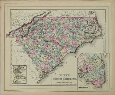
Sold20221877 Mitchell Map of North and South Carolina -- North and South CarolinaTitle: 1877 Mitchell Map of North and South Carolina -- North and South Carolina Cartographer: S Mitchell Date/Place: 1877 Philadelphia Dimensions: 10.5 x 13.5 in. Description: This is an excellent anSee Sold Price
Sold20211887 Mitchell Map of North and South Carolina -- NorthTitle: 1887 Mitchell Map of North and South Carolina -- North and South Carolina Cartographer: S Mitchell Year / Place: 1887, Philadelphia Map Dimension (in.): 11.3 X 14 in. A very nice map of the CarSee Sold Price
Sold20181867 Mitchell Map of North and South Carolina -- CountyTitle/Content of Map: 1867 Mitchell Map of North and South Carolina -- County Map of North and South Carolina Date: 1867, Philadelphia Cartographer: S Mitchell Size: 11.5 x 13.8 in. This is a handsomeSee Sold Price
Sold20211884 Mitchell Map of North and South Carolina -- NorthTitle: 1884 Mitchell Map of North and South Carolina -- North and South Carolina Cartographer: S Mitchell Year / Place: 1884, Philadelphia Map Dimension (in.): 11.3 X 14 in. This is a very nice map ofSee Sold Price
Sold2017Mitchell: Map of North America, 1848North America, S. Augustus Mitchell, 1848. 13 x 15.75 inches. Great transitional map showing political boundaries within that short time period after the Canadian/U.S. boundary settlement and before tSee Sold Price
Sold20181876 Mitchell Map of North and South Carolina -- NorthReserve Reduced! Title/Content of Map: 1876 Mitchell Map of North and South Carolina -- North and South Carolina Date: 1876 Philadelphia Cartographer: S Mitchell Size: 10.5 x 13.5 in. Excellent and hiSee Sold Price
Sold2020D'Anville Map of North America 1746The map of North America and the West Indies was one of the best French maps of North America prior to the French & Indian War. It was made by Jean Baptiste Bourguignon d’Anville (1697 - 1782) in PaSee Sold Price
BonhamsWOLLSTONECRAFT (MARY) A Vindication of the Rights of Men, FIRST EDITION, 1790; BURKE (EDMUND) Re...£1,800
18 hrs LeftTrillium Antique Prints & Rare BooksKohler & Weigel - Pair of Maps of the Americas: Map of North America (Part of Canada, Greenland,US$75(1 bid)
BonhamsMITCHELL (SAMUEL AUGUSTUS) A New Universal Atlas Containing Maps of the Various Empires, Kingdom...£1,300
18 hrs LeftTrillium Antique Prints & Rare BooksDe Jode, Rare, pub. 1593 - Maps of the Baltic, North Sea & Russia (Livoniae Provinciae Ac Eivs /US$100
4 days LeftJasper521760 MAP CARTE PARTICULIERE DE L'ISLE DE JUAN FERNANDES antique Robinson CrusoeUS$55
Jul 21The Heritage Gallery at Sayville Antiques, IncDonald Sultan L/E Serigraph Titled Franch Iris 2 1982US$50
Jul 21The Heritage Gallery at Sayville Antiques, IncDonald Sultan L/E Serigraph Titled Franch Iris 1 1982US$50
Jul 21The Heritage Gallery at Sayville Antiques, IncDonald Sultan L/E Serigraph Titled Franch Iris 3 1982US$50
18 hrs LeftTrillium Antique Prints & Rare BooksSanson - 4 Maps of Europe (Germany, Spain & Portugal, Hungary, & Poland)US$75
18 hrs LeftTrillium Antique Prints & Rare BooksSanson - 3 Maps of South America (Chili, Peru, Paraguay)US$75
18 hrs LeftTrillium Antique Prints & Rare BooksSanson - 5 Maps of Africa (Egypt, Barca, Tunis & Tripoli, Morocco, & Barbary & Alger)US$75
Jun 22Trillium Antique Prints & Rare BooksSanson - Map of the Antilles Islands or West Indies with part of FloridaUS$75
Featured5 days LeftJasper52Marshall Islands North Pacific Ocean Micronesia ADMIRALTY chart 1891 (1953) mapUS$120


![1869 Mitchell Map of North America [verso] Eastern Canada -- III Map of North America [verso] IV: Title: 1869 Mitchell Map of North America [verso] Eastern Canada -- III Map of North America [verso] IV Dominion of Canada Cartographer: S Mithchell Year / Place: 1869, Philadelphia Map Dimension (in.](https://p1.liveauctioneers.com/5584/293457/155766102_1_x.jpg?height=310&quality=70&version=1687903812)