Sold2018Belgium (Called Netherlands on Map) Large detailed MapBelgium (Called Netherlands on Map) Large detailed Map c1817 Thomson 20" x 26 3/4" Published in Edinburgh Scotland. Hand colored, copperplate engraved. Please note that this lot has a confidential resSee Sold Price
Sold2018Seutter: Antique Map of Belgium & Netherlands, 1740Title/Content of Map: Belgium & Netherlands or the United 17 Provinces Date Printed: c1740 Cartographer: Matthaus Seutter Material/Medium: Paper Size: 19" x 23" Original hand colored copperplate engraSee Sold Price
Sold20211690 ANTIQUE MAP OF LIMBURG NETHERLANDS by Frederik de1690 ANTIQUE MAP OF LIMBURG NETHERLANDS TABULA DUCATUS LIMBURCH ET COMITATUS VALCKENBURCH IN LUCEM EDITA A.F.WIT Copper-plate engraved map printed on laid paper,hand colored, no text on the verso By FSee Sold Price
Sold2018Colton: Antique Map of Netherlands, Belgium, 1859Netherlands, Belgium & Luxembourg with insterst of Brussels & Amsterdam 1859 H.J. Colton 17 1/2" x 15" Hand colored and engraved. Published in New York in Colton's 'General Atlas'. Please note that thSee Sold Price
Sold20241839 Map of Netherlands and Belgium by MoninTitle: 1839 Map of Netherlands and Belgium by Monin Date/Period: 1839 Materials: Hand colored, engraved Size: 17 1/2” x 12 1/2” Netherlands and Belgium with Luxembourg. 1839. By V. Monin.See Sold Price
Sold2017Colton: Antique Map of Netherlands and Belgium, 1861Title/Content of Map: Colton's Netherlands and Belgium Date Printed: 1861 Cartographer: J. H. Colton Material/Medium: Paper Size: 17 1/2" x 13 3/4" Hand colored. Steel engraved. From 'Colton's GeneralSee Sold Price
Sold2020Hand colored copper engraved map by Homann, 1715Johann Baptist Homann (German, 1664-1724), hand colored copper engraved map, 1715, 'Provinciae XVII Infer. Germaniae,' depicting the Netherlands, Belgium, and Luxembourg in addition to parts of FranceSee Sold Price
Sold2019Netherlands and BelgiumTitle/Content of Map: Netherlands and Belgium Date: 1861 Cartographer: Johnson Material/Medium: steel engraved Size: 18x14” Provenance: New York Additional Info: Hand colored Reserve: $20.00 ShippinSee Sold Price
Sold2017Mitchell: Antique Map of Russia in EuropeTitle/Content of Map: Russia in Europe with Denmark Netherlands and Belgium in inserts Date Printed: 1905-02 Cartographer: Augustus S. Mitchell Material/Medium: Paper Size: 15" x 12" Hand colored engrSee Sold Price
Sold2022Netherlands with N.W Germany & Belgium, 1780/81. Scarce map by J. B. NolinTitle: Netherlands with N.W Germany & Belgium, 1780/81. Scarce map by J. B. Nolin Date/Period: 1780/81 Dimension: 14 1/2 x 10 1/4” Material: Hand colored copper plate engraved Additional InformaSee Sold Price
Sold2019Barclay, James 1809 Antique Map. Netherlands & Belgium"The Seven United Provinces, with The Dutch Possessions in Flanders, Brabant and Limburg" Outline Hand Coloured Copper Engraved Map Published 1809, Leeds for "Barclay's Complete and Universal DictionaSee Sold Price
Sold20191786 Hand Colored Map of NetherlandsMap Elwe and Langeveld - Kaartje van de X provincien der Nederlanden inhoudende Braband, Vlaanderen enz. – 1786. Fine, measures 10 x 8”. Reserve: $20.00 Shipping: Domestic: Flat-rate of $5.00 to aSee Sold Price
Sold2018Antique French Copper Engraved Colored Map, Amsterdam18th century antique French copper engraved and hand colored maps of Amsterdam, Netherlands titled "Lemouicum, Auctore Jo. Faiano M.L. - Lymosin [on sheet with] Topographia Limaniae, Auctore GabrieleSee Sold Price
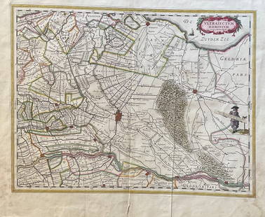
Sold2023The Netherlands Map. The region Around the city of Utrecht. 1660?s by W. BlaeuTitle: The Netherlands Map. The region Around the city of Utrecht. 1660?s by W. Blaeu Date/Period: 1660?s Materials: Hand colored copper plate engraved Size: 22 x 19 1/2'' Netherlands regional map cenSee Sold Price
Sold20231848 Hand Colored Mitchell Map of Holland & BelgiumDated 1848 in upper RH corner, Mitchell hand colored map of Holland and Belgium, in frame measuring 15" x 18" in size.See Sold Price
Sold2018Netherlands & Belgium. 1843 by Tanner. 14x17”. HandNetherlands & Belgium. 1843 by Tanner. 14x17”. Hand colored. Philadelphia. Please note that this lot has a confidential reserve. When you leave a bid in advance of the auction, submit your maximum.See Sold Price
Sold2022Netherlands, Belgium, Luxembourg. 1780, by J. de laTitle: Netherlands, Belgium, Luxembourg. 1780, by J. de la Porte, Paris Date/Period: 1780 Materials: Hand colored copper plate engraved Size: 9x7'' Condition, center fold separation on bottom otherwisSee Sold Price
Sold2022Netherlands, Belgium, Luxembourg and Westphalia region of Germany. 1794 by Vaugondy/DelamarcheTitle: Netherlands, Belgium, Luxembourg and Westphalia region of Germany. 1794 by Vaugondy/Delamarche Date/Period: 1794 Dimension: 16 x 11 1/2" Material: Hand colored copper plate engraved. AdditionalSee Sold Price
Sold2020Barclay, James C1835 Pair of Hand Col Maps. NetherlandsHand Colored Copper Engraved Map Published C1835, London for "A Complete and Universal English Dictionary" by the Rev. James Barclay et al. Folds as issued. Paper Size: 11 x 8.5 inch (28 x 22cm) GoodSee Sold Price
Sold2022Barclay, James 1812 Hand Col Map. Netherlands"The Severn United Provinces..." Hand Colored Copper Engraved Map Published 1812-13 by Brightly & Childs, Bungay for "A Complete and Universal Dictionary of the English Language..." by the Rev. JamesSee Sold Price
Sold2022Barclay, James 1812 Hand Col Map. NetherlandsHand Colored Copper Engraved Map Published 1812-13 by Brightly & Childs, Bungay for "A Complete and Universal Dictionary of the English Language..." by the Rev. James Barclay. Paper Size: 10.5 x 8 incSee Sold Price
Sold2024NICOLAES VISSCHER (NETHERLANDS, 1618-1709) MAP OF THE NEW WORLD"Novi Belgii Novaeque Angliae nec non Partis Virginie Tabula multis in locis emendata", 1656. Handcolored copperplate engraving on two joined sheets of wove paper as issued. Features cartouche panoramSee Sold Price
Sold202417C. Willem & Jan Blaeu Map of VenezuelaWillem & Jan Blaeu Netherlands 17th Century Hand colored map of Venezuela and the lower Antilles created by Willem Blaeu and Jan Blaeu with glass back to feature atlas pages. Lithograph on paper,ImageSee Sold Price
Sold2021Antique Engraved Map of GovdaAn antique hand colored map of Govda (Gouda, Netherlands) by J. Blaeu (1596-1673). Framed under glass. Mat opening: 15 in x 19-1/2 in.See Sold Price
5 days LeftTrillium Antique Prints & Rare BooksBraun & Hogenberg, pub. 1575 - View of Bergen op Zoom, NetherlandsUS$100
6 days LeftGrace Auction & Estate Gallery LLCAntique Hand Colored Map Johann Baptist Homann. Fluviorum in Europa Principis DanubiiUS$100
6 days LeftGrace Auction & Estate Gallery LLCAntique Hand Colored Map Bernardo Brognolo Veronae Vrbis Territorivm, Theatrum Orbis TerrarumUS$100
2 days LeftJasper52Johnson's New York & Adjacent Cities. Brooklyn Manhattan Jersey City 1866 mapUS$300


![Antique French Copper Engraved Colored Map, Amsterdam: 18th century antique French copper engraved and hand colored maps of Amsterdam, Netherlands titled "Lemouicum, Auctore Jo. Faiano M.L. - Lymosin [on sheet with] Topographia Limaniae, Auctore Gabriele](https://p1.liveauctioneers.com/6377/128239/65869733_1_x.jpg?height=310&quality=70&version=1540604375)