Sold2018HAND COLORED MAP. *INSULA S. JUAN DE PERTO RICO, CAIBESHAND COLORED MAP. *INSULA S. JUAN DE PERTO RICO, CAIBES VEL CANIBALUM INSULAE* BY JANSON. 20 3/8 X 16 INCH IMAGE. HAS UNEVEN TONING. VERTICAL CREASE IN THE CENTER. HAS PROFESSIONAL REPAIRS AND HAS BEESee Sold Price
Sold2017Jansson: Antique Map Puerto Rico/Lesser Antilles, 1650Map: Insula S. Juan de Puerto Rico, Caribes vel Canibalum Insulae Cartographer: Jansson Place & Date: Amsterdam / 1650 Size: 20 1/4" x 16" Condition: original wash and outline color; overall age toninSee Sold Price
Sold2017(MAP, SICILY) DE WIT, FREDERICK. Insula sive regnumMAP, SICILY by DE WIT, FREDERICK, Insula sive regnum Siciliae urbibus praecipuis exornatum. Amsterdam, circa 1680. Hand-colored engraved map of Sicily. With inset plans of Messina, Milazzo and PalermoSee Sold Price
Sold2021Antique MapsGrouping of Two (2) Antique Engraved Maps. Includes a J.H. Colton & Co hand colored map of Cuba, Jamaica, and Puerto Rico together with a Jacques-Nicolas Bellin "Carte de la Nouvelle Angleterre, NouveSee Sold Price
Sold2021(16) 19TH C. MAPS OF THE WEST INDIES IN FOLIO,Including: "L'Isle de Ste. Domingue, et celle de Porto Rico", by Bonne, hand colored engraving,1778, 10" x 14 1/2"; PLUS "West Indies", Smith's Atlas, 1808, hand colored engraving, 1808, 11" x 14"; PLSee Sold Price
Sold2021[MAPS] HOMANN, JOHAN BAPTISTE. Insulae et Principatus[MAPS] HOMANN, JOHAN BAPTISTE. Insulae et Principatus Rugiae... Nuremberg: circa 1730. 18 3/4 x 22 1/8 inches, hand-colored engraving; Together with ROBERT DE VAUGONDY, GILLES & DIDIER. La Prusse diviSee Sold Price
Sold2023Antique Map of Ireland, Frederick de WittDutch, 1629-1706..REGNI et INSULAE HIBERNIAE, latter 17th century, hand colored copper plate engraving, sight 28 x 19.5 in..toning, areas of foxing and discoloration, creases, under glass, not examineSee Sold Price
Sold2017Antique Map, "Carte de l'Isle de Belle-Isle"Antique Hand colored Map, "Carte de l'Isle de Belle-Isle". With pencil inscription verso. Sight size: 8.5 x 14 inches.See Sold Price
Sold2022THREE HAND-COLORED MAPSTHREE HAND-COLORED MAPS1) “Insulae Indiae Orientalis” from the Mercator/Hondius Atlas Minor, Mid-16th Century. 6” x 7.75” sight. Framed 12.25” x 14.25”.2) "DeSee Sold Price
Sold20221755 Map of North America by De VaugondyHistoric Maps 1755 French & Indian War Era Map of North America by De Vaugondy 1755-Dated French & Indian War Era, Large Hand-Colored Map titled, "PARTIE DE L'AMERIQUE SEPTENTRIONALE, QUI COMPREND LESee Sold Price
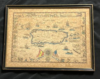
Sold2023Vintage Hand -Colored Pictorial Map of Puerto Rico Circa 1931 by E.B.K. DooleyA vintage hand-colored map of Puerto Rico by E.B.K. Dooley, published c. 1931. This map has a decorative border filled with local plants, wildlife, buildings and transportation. In small scrolls, therSee Sold Price
Sold2023Antique French Map Isle de Saint ChristopheAntique MDCCLVIII French Language Hand Colored Map of Isle de Saint Christophe (St. Kitts), Framed. 31 inches x 42 inchesSee Sold Price
Sold2022Seventeenth Century Map of Northern ScotlandHand colored map titled "Is DE FARO DE SCHELAND ORKNAY ET HEBRIDES" by French cartographer Mallet Alain, Paris, 1683. Framed map measures 5.5" x 4" (sight) and shows northern Scotland as well as the HSee Sold Price
Sold20211796 Josephe de Laporte map of China1796 Josephe de LaPorte hand colored map "L'Empire de la Chine avec les Isles Du Japon et la Coree", sight 7 1/4" x 8 3/4", well framed, overall 12" x 14"See Sold Price
Sold20241781 Antonio Zatta Map Of The West IndiesDESCRIPTION: Antique hand colored map entitled "Stabilimenti de Francesi, Inglesi, E Spagnuoli nelle Isole Anteille Di nuova Projezione" by Antonio Zatta depicting the West Indies and portions of FlorSee Sold Price
Sold20172 early maps, Chili & Auriacus Princip, by Ortelius.2 Antique Hand-Colored Map Prints, "Royaume de Chili", a miniature map of Chili, South America ; and "Auriacus Principatus" ( by Ortelius), showing the region around the Roman city of Orange in southeSee Sold Price
Sold2022EBK Dooley Hand Colored Puerto Rico Pictorial MapAntique hand colored map of Puerto Rico by EBK Dooley (Eliza Bellows King Dooley), published 1931. No tares and color it still vibrant.See Sold Price
Sold2024Matthaus Merian 1627 Antique Hand Colored Map "Virginia" from Theodore de Bry's "Grand Voyages" #2Antique 1627 hand-colored map of Virginia by Matthaus Merian after John Smith's 1612 map, from Theodore de Bry's "Grand Voyages". Good condition overall, with age-appropriate wear, repairs (see photosSee Sold Price
Sold2020Nicolas Sanson Atlantis Insula Map Hand Colored ENicolas Sanson (1600-1677), "Atlantis Insula," Amsterdam: Mortier, ca. 1700. This wonderful hand colored engraving map of America purportedly shows the Western Hemisphere about 200,000 years ago beforSee Sold Price
Sold20211757 Hand-Colored Map of Virginia and the ChesapeakeHistoric Maps Hand-Colored Map of Virginia and the Chesapeake Bay Area 1757, French and Indian War Period, Hand-Colored Engraved Map titled, "Carte De La Virginie, De La Baye Chesapeack et Pays VoisinSee Sold Price
Sold20241770 Map of Chesapeake Engraving Hand ColoredHand-Colored Map of Virginia and the Chesapeake Bay Area 1757, French and Indian War Period, Hand-Colored Engraved Map titled, "Carte De La Virginie, De La Baye Chesapeack et Pays Voisins," bySee Sold Price
Sold20221761 Map of Carthage as Part of Roman Empire EtcHistoric Maps 1761 Map: "SUITE DE L'HISTOIRE DE CARTHAGE,..." 1761-Dated French & Indian War Period, Hand-Colored Map fully titled, "SUITE DE L'HISTOIRE DE CARTHAGE, DEPUIS L'AN 3786 JUSQU'A L'AN 3860See Sold Price
Sold2020Amerique Septentrionale.Amerique Septentrionale. Hand-colored engraved map by Robert de Vaugondy, 1750 18.75" x 23" Frame: 29" x 33.75"See Sold Price
Sold2018(2) antique maps of Europe by Nicolas De Fer(2) antique maps of Europe by Nicolas De Fer, "Les Suisses, Leurs Sujets et Leurs Alliez", black and white map, 1715 and "Le Golfe De Venise", hand-colored map, 1716, by Nicolas De Fer and P. StarckmaSee Sold Price
Jun 09Worthington GalleriesAntique Hand-colored Hemisphere Map Mappemonde Revue par E. Cortambert 1864US$25
Jun 14DuMouchellesRigobert Bonne (French, 1727-1794) Hand Colored Engraving Ca. 18th Century, Les Etats Unis DeUS$50
Jun 09Worthington Galleries18th c. Map OBSERVATIONS SUR LES POINTS CARDINAUX. LIGNES, ET CIRCLES DE LA SPHÈUS$10
2 days LeftJasper52Large Antique French map GERMAN EMPIRE 1792 colored by POIRSON engraver BassetUS$170
236 Lots AwayArarity AuctionsThomson's 1817 Hand Colored Map Comparative Heights of the World's Great MountainsUS$50
Jun 09Worthington GalleriesFirst Edition Hand-colored Map THE NORTH RIDING OF YORKSHIRE by Robert MordenUS$50
Jun 08Early American History Auctions1836 Hand-Colored Map, Country Twenty Five Miles Round The City Of New-York Published by D.S. StoneUS$260
Jun 08Early American History Auctions1776 Map, PARTIE ORIENTALE DU CANADA, AVEC LA NOUVELLE ANGLETERRE, L'ACADIE... by P. Santini, FramedUS$950
237 Lots AwayArarity AuctionsC. G. Reichard "Charte des Osmanische Reichs in Asien" 1804 Antique Hand Colored Framed MapUS$50
5 days LeftFreeman's | Hindman[CIVIL WAR]. Hand-colored CDV of the battle-torn National Colors of the 82nd Pennsylvania Infantry.US$200(1 bid)


![[MAPS] HOMANN, JOHAN BAPTISTE. Insulae et Principatus: [MAPS] HOMANN, JOHAN BAPTISTE. Insulae et Principatus Rugiae... Nuremberg: circa 1730. 18 3/4 x 22 1/8 inches, hand-colored engraving; Together with ROBERT DE VAUGONDY, GILLES & DIDIER. La Prusse divi](https://p1.liveauctioneers.com/292/204169/103522322_1_x.jpg?height=310&quality=70&version=1621026354)


![[CIVIL WAR]. Hand-colored CDV of the battle-torn National Colors of the 82nd Pennsylvania Infantry. (1 of 1)](https://p1.liveauctioneers.com/197/329785/177758302_1_x.jpg?height=282&quality=70&version=1715625218)


